IMAGES TAKEN NEAR TO
Kirkland Lane, ALEXANDRIA, G83 9LZ
Introduction
This page details the photographs taken nearby to Kirkland Lane, G83 9LZ by members of the Geograph project.
The Geograph project started in 2005 with the aim of publishing, organising and preserving representative images for every square kilometre of Great Britain, Ireland and the Isle of Man.

There are currently over 7.5m images from over14,400 individuals and you can help contribute to the project by visiting https://www.geograph.org.uk
Image Map
Images are licensed for reuse under creativecommons.org/licenses/by-sa/2.0
Notes
- Clicking on the map will re-center to the selected point.
- The higher the marker number, the further away the image location is from the centre of the postcode.
Image Listing (113 Images Found)
Images are licensed for reuse under creativecommons.org/licenses/by-sa/2.0
Image
Details
Distance
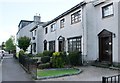
1

Former manse, Bonhill South Church
Image: © Richard Sutcliffe
Taken: 11 May 2019
0.02 miles
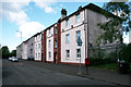
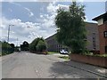
4
Croft Street, Bonhill
The photo was taken from near one end (the junction with George Street), and shows the view towards the other end, where it meets Main Street.
Image: © Lairich Rig
Taken: 4 Aug 2008
0.03 miles
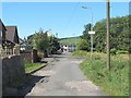
6
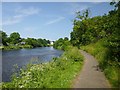
Path to Bonhill Bridge
Compare Image, taken from further along the same path. As in that view, part of Image can be seen at the far left. Further along that side of the Leven is some of the recently-built Image
Image: © Lairich Rig
Taken: 7 Jul 2013
0.07 miles
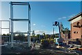
7

Construction of Old School Place
The view is from Main Street, near the north-eastern corner of the construction site; it shows the northern end of the site.
For the southern part of the site, and for further information, see Image
Image: © Lairich Rig
Taken: 8 Jul 2017
0.08 miles

9
Main Street, Bonhill and Old School Place
Looking south from Main street, Bonhill with Old School Place on the right hand side. This block of flats is built on the site of the old Bonhill Primary School. Over 40 new homes on site.
Image: © George Rankin
Taken: 6 Aug 2019
0.08 miles
10
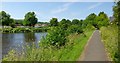
Path to Bonhill Bridge
Click on the end-note title for other pictures taken on the same route. In the present view, Image can be seen on the other side of the Leven.
Image: © Lairich Rig
Taken: 7 Jul 2013
0.08 miles