IMAGES TAKEN NEAR TO
The Lade, ALEXANDRIA, G83 9JR
Introduction
This page details the photographs taken nearby to The Lade, G83 9JR by members of the Geograph project.
The Geograph project started in 2005 with the aim of publishing, organising and preserving representative images for every square kilometre of Great Britain, Ireland and the Isle of Man.

There are currently over 7.5m images from over14,400 individuals and you can help contribute to the project by visiting https://www.geograph.org.uk
Image Map
Images are licensed for reuse under creativecommons.org/licenses/by-sa/2.0
Notes
- Clicking on the map will re-center to the selected point.
- The higher the marker number, the further away the image location is from the centre of the postcode.
Image Listing (54 Images Found)
Images are licensed for reuse under creativecommons.org/licenses/by-sa/2.0
Image
Details
Distance
1
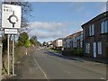
Entering Jamestown
John Neill's 1912 book "Records and Reminiscences of Bonhill Parish" offers, on page 43, an explanation for the name Jamestown. I cannot vouch for its correctness, but it is worth quoting here, for interest:
"In 1773 a schoolhouse was erected at Dam of Balloch, now called Jamestown, from the fact that three feuars whose individual Christian name was James, had each built a house there."
Image: © Lairich Rig
Taken: 15 Feb 2013
0.03 miles
2
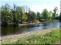
A skimmer in the River Leven
The stone structure shown at the centre of the photograph is more visible than usual after a period of dry weather, which had lowered the Leven's level. It is a "skimmer", directing some of the flow of the river into a lade. In this case, the lade served Dalmonach Print Works (for which, see Image).
For other examples on the River Leven, see Image and Image
Image: © Lairich Rig
Taken: 2 May 2011
0.04 miles
3
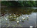
Water-crowfoot in the River Leven
(Ranunculus sp.)
The level of the river was low, making it easier to approach the plants, and causing the long stems to trail horizontally. The common name Water-crowfoot does not apply to just one species, but to several different ones that are superficially alike.
Image: © Lairich Rig
Taken: 22 Jun 2016
0.06 miles
4
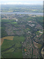
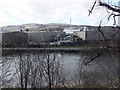
Vale of Leven and the River Clyde from the air
Most of the six mile length of the River Leven can be seen in this photo which was taken from a Glasgow bound flight from Newark USA.
Image: © Thomas Nugent
Taken: 15 Jul 2011
0.07 miles
5
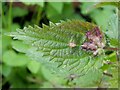
Leaf galls on nettle
These are caused by the gall midge species Dasineura urticae. They are pale green to purple, and have a slit-shaped opening (usually on the upper surface; see http://www.geograph.org.uk/photo/992628 for an example). When the photo was taken, this gall was very common on the nettles growing alongside the cycle route between Renton and Balloch.
For another common gall on nettles that is caused by a fungus rather than an insect, see: Image
Image: © Lairich Rig
Taken: 21 Sep 2008
0.07 miles
6
Loch Lomond Brewery
Viewed across the River Leven from the A813 south of Jamestown. See http://lochlomondbrewery.com/about-us .
Image: © Barbara Carr
Taken: 21 Apr 2013
0.09 miles
7
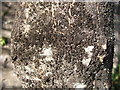
Warehouse Staining Fungus
At this point (see Image for context), the cycle route is hemmed in by the River Leven on one side, and a wall on the other; behind the wall, whisky barrels are piled high (a distillery is located there). Along this portion of the route, many of the trees beside the path are visibly blackened. This is often the case in areas that are close to bonded warehouses: trees, walls, and even houses often become covered in a dark mould. The photo shows the bark of one affected tree; a fairly featureless black mould covers much of the surface, contrasting with the lighter-coloured fresh surfaces that have been exposed by cracks in the bark.
The role that the proximity of whisky bonds plays in the formation of this mould has frequently been played down by the industry(*). However, when I was on a tour of a (different) distillery, the tour guide pointed out a similar black mould on a wall, beside which barrels were being stored, and he ascribed it to the Angels' Share (the name given to the portion of whisky that is lost each year from barrels through evaporation).
(Such staining is also evident elsewhere on the course of the River Leven; near the Black Bridge, Image, there are bonded warehouses on the eastern side of the river.)
Not for nothing is the common name of this mould "Warehouse Staining Fungus"; it is a phenomenon that has long been familiar from sites associated with Cognac production in mainland Europe.
For those who wish to know more about these black moulds and their causes, "warehouse staining fungus" is a useful search expression (another is "Baudoinia compniacensis").
- - • - -
(*) When disavowing responsibility for the mould, industry spokespersons tend to take a predictable tack, speaking about "microflora", presumably because it sounds more pleasant than "mould".
They may go on to say that it consists of organisms which "occur naturally in the environment" — a true but pointless observation, since no one imagines that this mould was genetically engineered in the lab, like a bio-weapon. The real issue is its much greater abundance in this particular environment.
They may finally add that "the organism grows where the environment supports it", or words to that effect. That observation is also true, but not very profound: it tells us that the mould grows where it *can* grow, rather than growing where it *cannot* grow. (I was reminded of official advice, later mocked, that was given to "grow-your-own" enthusiasts during WWII: "do not grow your potatoes where they will not grow".) Exposure to ethanol vapour enables the mould to flourish in environments that would otherwise prove too harsh for it. The mould grows in abundance near bonded warehouses because "the environment supports it", the proximity of bonded warehouses being an important element of that environment.
(If I come across any new tactics, I will, in time, add them to this description, with further comments of my own. I have no quarrel with the whisky industry, and I enjoy their product, but I hate spin, whatever its source, and I particularly enjoy deconstructing irrelevancies that are couched in technical language in an attempt to bamboozle the general public.)
Image: © Lairich Rig
Taken: 17 Oct 2007
0.10 miles
8
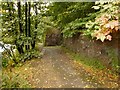
Footpath beside the River Leven
Alongside this section of the path is a wall, a relic of one of the buildings of Milton Works (a dyeworks that was already gone by the time of the Second World War). The River Leven itself is the bright area seen through the trees on the left.
Image: © Lairich Rig
Taken: 5 Oct 2012
0.12 miles
9
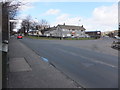
Auchincarroch Road
Junction with the A813. Auchincarroch Road leads to Auchencarroch (I wonder when the difference in spelling crept in?).
Image: © Barbara Carr
Taken: 21 Apr 2013
0.13 miles
10
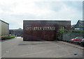
Antartex Village entrance
Shopping complex on part of distillery site
Image: © John Firth
Taken: 10 May 2011
0.13 miles