IMAGES TAKEN NEAR TO
Main Street, ALEXANDRIA, G83 9HS
Introduction
This page details the photographs taken nearby to Main Street, G83 9HS by members of the Geograph project.
The Geograph project started in 2005 with the aim of publishing, organising and preserving representative images for every square kilometre of Great Britain, Ireland and the Isle of Man.

There are currently over 7.5m images from over14,400 individuals and you can help contribute to the project by visiting https://www.geograph.org.uk
Image Map
Images are licensed for reuse under creativecommons.org/licenses/by-sa/2.0
Notes
- Clicking on the map will re-center to the selected point.
- The higher the marker number, the further away the image location is from the centre of the postcode.
Image Listing (134 Images Found)
Images are licensed for reuse under creativecommons.org/licenses/by-sa/2.0
Image
Details
Distance
1
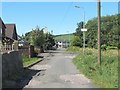
Croft Street, Bonhill
The photo was taken from near one end (the junction with George Street), and shows the view towards the other end, where it meets Main Street.
Image: © Lairich Rig
Taken: 4 Aug 2008
0.02 miles
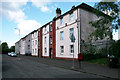
3
Campbell Street Bonhill
View of Campbell Street in Bonhill from Main Street looking east.
Image: © George Rankin
Taken: 25 Jun 2007
0.06 miles

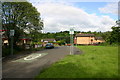
5

Former manse, Bonhill South Church
Image: © Richard Sutcliffe
Taken: 11 May 2019
0.06 miles
6
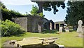
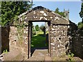
Bonhill Kirkyard: southern boundary wall
A number of vaults and other enclosures are ranged along the southern wall of the kirkyard. The area had previously been rather overgrown, but it has recently been tidied up a great deal (due credit to the workers for their efforts here), and the various vaults and enclosures now present a much more attrachtive appearance. This has had the added benefit, for me, of making it much easier to depict the various structures photographically.
For convenience, I will number them from left to right (east to west) in what follows. For much more information about each vault, see the links given in the corresponding paragraphs below:
(1) The nearest of the structures is the vault for the Turnbulls of Place of Bonhill. For some views of it, and for more information, see Image and Image Immediately to its left, there was originally a watch-house (from which a vigil would be kept so that newly-buried bodies would not be stolen by grave-robbers), but it is long gone. There are some fragments of masonry in the bushes in that area, and it is possible that they are those of the watch-house.
(2) The next vault, with an apex above the entrance, is that of the Arthurs of Dillichip (or of Levenback, as they might equally well be described): see Image and Image It is appropriate that this vault is adjacent to that of the Turnbulls, because the families were related both by business and by marriage.
(3) The furthest of the three visible vaults has no lintel above the entrance, and contains nothing that could identify its owner. There is nothing inside, apart from a single stone tablet on the back wall, but any traces of an inscription on that stone have entirely disappeared. For that reason, it is probably helpful if I mention here that this is the Carmichael vault. See Image for further details.
Further along the same wall are more vaults and enclosures; since they are out of sight in the present view, I have shown them separately from a different viewpoint: Image In that item, I carry on with the same numbering scheme (east to west) that I adopted in the present item (for enclosures 1 to 3), and show enclosures 4 to 7.
Image: © Lairich Rig
Taken: 7 Jul 2013
0.07 miles
7
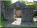
Mausoleum of Arthur of Levenbank
For context, see Image, where this structure can be seen right of centre. The mausoleum for the Arthur family of Levenbank (or of Dillichip) dates from 1797, and therefore pre-dates the existing church building.
Out of shot to the left is the Image; it is appropriate that the structures are side by side, because Robert Arthur was married to Marion Turnbull. There was also a business connection: the firm of Turnbull & Arthur carried on calico printing at Dillichip; after the death of Robert Arthur, the works were acquired by Archibald Orr Ewing.
There is a badly worn inscription on the back wall of this classical vault. See Image for a view from within.
Image: © Lairich Rig
Taken: 7 Jul 2013
0.07 miles
8
The Arthur Mausoleum: interior
See Image for the outside, and for the main description; see Image for context.
In the present view, parts of Image can be seen in the background.
Image: © Lairich Rig
Taken: 7 Jul 2013
0.07 miles
9
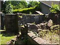
Mausoleum of the Rouets of Auchendennan-Rhie
(See Image for context.)
The broken down near wall allows a view into this partly ruined structure: two tablets can be seen on its far wall. The top of the larger tablet, on the left, has flaked off.
It is unfortunate that part of the text of the tablets has gone, but the taller tablet on the left was erected by Miss Mary Rainey Rouet of Bel-Retiro to the memory of her mother, Mrs Elizabeth Sarah Rainey Rouet (d. 23rd March 1834), relict of Daniel Rainey.
The smaller tablet on the right commemorates Mary Rainey Rouet herself, "hastily summoned from time to eternity" on the 6th of May, 1841. "In the midst of life we are in death".
The full text of the inscriptions on these tablets (including the parts that have flaked away) can be found on page 159 of Donald MacLeod's "Historic Families ... of the Lennox" (1891).
The lands of Auchendennan-Rhie passed through several hands after the death of Miss Rouet, before they were acquired by George Martin of Auchendennan: Image (that item also comments on the name "Bel-Retiro", mentioned above).
See also Image (located in a different cemetery); the first wife of Rear Admiral Smollett, who is discussed in that item, was a daughter of William Rouet of Auchendennan.
Image: © Lairich Rig
Taken: 7 Jul 2013
0.07 miles
10
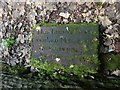
Memorial to Archibald Murray
For context, see Image This is one of a few stones that have presumably fallen out of the southern boundary wall of the kirkyard, and which have ended up at the side of the path. Its text is not included in the list of pre-1855 monumental inscriptions for the area, and so is worth giving here. It reads as follows (where I've relied on my local knowledge to determine the reading of the less legible parts):
"HERE LYES THE BODY [OF]
ARCHIBALD MURRAY LA[TE]
FARMER IN HILL [OF]
NAPIER[STON]"
Hill of Napierston, earlier known as Hilltoun of Napierstoun, was one of the local farms; for example, it is mentioned, in passing, on page 169 of the second volume of Joseph Irving's "Book of Dumbartonshire" (1879). On the Napiers in this area, see also Image
Image: © Lairich Rig
Taken: 27 Nov 2012
0.07 miles