Bonhill Kirkyard: southern boundary wall
Introduction
The photograph on this page of Bonhill Kirkyard: southern boundary wall by Lairich Rig as part of the Geograph project.
The Geograph project started in 2005 with the aim of publishing, organising and preserving representative images for every square kilometre of Great Britain, Ireland and the Isle of Man.

There are currently over 7.5m images from over 14,400 individuals and you can help contribute to the project by visiting https://www.geograph.org.uk
Bonhill Kirkyard: southern boundary wall
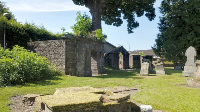
Image: © Lairich Rig Taken: 7 Jul 2013
A number of vaults and other enclosures are ranged along the southern wall of the kirkyard. The area had previously been rather overgrown, but it has recently been tidied up a great deal (due credit to the workers for their efforts here), and the various vaults and enclosures now present a much more attrachtive appearance. This has had the added benefit, for me, of making it much easier to depict the various structures photographically. For convenience, I will number them from left to right (east to west) in what follows. For much more information about each vault, see the links given in the corresponding paragraphs below: (1) The nearest of the structures is the vault for the Turnbulls of Place of Bonhill. For some views of it, and for more information, see Image and Image Immediately to its left, there was originally a watch-house (from which a vigil would be kept so that newly-buried bodies would not be stolen by grave-robbers), but it is long gone. There are some fragments of masonry in the bushes in that area, and it is possible that they are those of the watch-house. (2) The next vault, with an apex above the entrance, is that of the Arthurs of Dillichip (or of Levenback, as they might equally well be described): see Image and Image It is appropriate that this vault is adjacent to that of the Turnbulls, because the families were related both by business and by marriage. (3) The furthest of the three visible vaults has no lintel above the entrance, and contains nothing that could identify its owner. There is nothing inside, apart from a single stone tablet on the back wall, but any traces of an inscription on that stone have entirely disappeared. For that reason, it is probably helpful if I mention here that this is the Carmichael vault. See Image for further details. Further along the same wall are more vaults and enclosures; since they are out of sight in the present view, I have shown them separately from a different viewpoint: Image In that item, I carry on with the same numbering scheme (east to west) that I adopted in the present item (for enclosures 1 to 3), and show enclosures 4 to 7.
Images are licensed for reuse under creativecommons.org/licenses/by-sa/2.0
Image Location
Latitude
55.982094
Longitude
-4.574239