IMAGES TAKEN NEAR TO
Ladyton Estate, ALEXANDRIA, G83 9DW
Introduction
This page details the photographs taken nearby to Ladyton Estate, G83 9DW by members of the Geograph project.
The Geograph project started in 2005 with the aim of publishing, organising and preserving representative images for every square kilometre of Great Britain, Ireland and the Isle of Man.

There are currently over 7.5m images from over14,400 individuals and you can help contribute to the project by visiting https://www.geograph.org.uk
Image Map
Images are licensed for reuse under creativecommons.org/licenses/by-sa/2.0
Notes
- Clicking on the map will re-center to the selected point.
- The higher the marker number, the further away the image location is from the centre of the postcode.
Image Listing (66 Images Found)
Images are licensed for reuse under creativecommons.org/licenses/by-sa/2.0
Image
Details
Distance
1
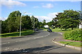
Towards O'Hare Estate
View looking from the junction on the A813 looking towards O'Hare Estate Bonhill
Image: © George Rankin
Taken: 25 Jun 2007
0.02 miles
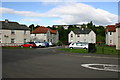
2
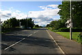
A813 Ladyton Bonhill looking North
View along the A813 near Ladyton Bonhill looking North, at the end of the road can be seen Ben Lomond in the distance.
Image: © George Rankin
Taken: 25 Jun 2007
0.04 miles
3
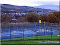
Playpark for local housing estate. Bonhill
Image: © Dumgoyach
Taken: 14 Nov 2006
0.07 miles
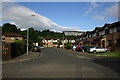
4
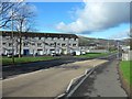
Bonhill, West Dunbartonshire
The Ladyton and O'Hare areas to the north.
Image: © Stephen Sweeney
Taken: 4 Mar 2012
0.09 miles
5
George Street Lane. Bonhill.
View of George Street Lane, Bonhill from George Street looking east.
Image: © George Rankin
Taken: 25 Jun 2007
0.11 miles
6
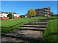
Steps at Ladyton
A housing association is carrying out work on the building at the top of the steps, and on others nearby (out of shot).
Image: © Lairich Rig
Taken: 14 Oct 2018
0.11 miles
7
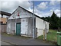
The Wee Hut
"The Wee Hut" Finlayson's in George Street, which like a few other small shops started out as a wooden hut. It passed on to George street resident Gertie Mooney and in the 50's it was sold to Johnnie Allen and later to another George Street resident, George McGinty. For a short period of time 1975 the local V.O.L. Cooperative Soc. ran the shop, until it was taken over as a storage area for various groups.
Image: © George Rankin
Taken: 6 Aug 2019
0.11 miles
8
Springcroft Grove Bonhill
View of Springcroft Grove, Bonhill from George Street this development is built on the site of the former McDougall's Lemonade Factory which produced lemonade from a local spring.
Image: © George Rankin
Taken: 25 Jun 2007
0.11 miles
9
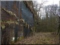
Bonhill Quarry
This is the back (or eastern) rock face of the disused quarry. For a closer look at the surface, see Image
Image: © Lairich Rig
Taken: 11 Mar 2016
0.12 miles
10
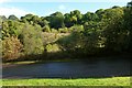
The former Bonhill Quarry
The disused quarry is shown here in a view from the other side of Hillbank Street (in the foreground).
Only a small patch of the sheer rock face is visible through the trees; it appears centrally in the background. For much a closer look, see Image
Image: © Lairich Rig
Taken: 5 Oct 2012
0.12 miles