IMAGES TAKEN NEAR TO
Nobleston Estate, ALEXANDRIA, G83 9DA
Introduction
This page details the photographs taken nearby to Nobleston Estate, G83 9DA by members of the Geograph project.
The Geograph project started in 2005 with the aim of publishing, organising and preserving representative images for every square kilometre of Great Britain, Ireland and the Isle of Man.

There are currently over 7.5m images from over14,400 individuals and you can help contribute to the project by visiting https://www.geograph.org.uk
Image Map
Images are licensed for reuse under creativecommons.org/licenses/by-sa/2.0
Notes
- Clicking on the map will re-center to the selected point.
- The higher the marker number, the further away the image location is from the centre of the postcode.
Image Listing (31 Images Found)
Images are licensed for reuse under creativecommons.org/licenses/by-sa/2.0
Image
Details
Distance
1
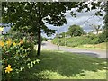
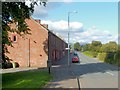
Junction, Bonhill signage
Stirling Road A813 looking north, Junction to Main Street Bonhill left of Bonhill signage, Stirling Road continues northward beyond Bonhill signage. Nobleston Estate on top right of photograph.
Image: © George Rankin
Taken: 6 Aug 2019
0.05 miles
2
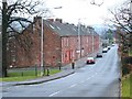
Road junction
Stirling Road is on the right, and Main Street, Bonhill, on the left.
In the left background, Image can be seen indistinctly beside Main Street. The houses on the higher ground at the far right are in Nobleston.
Image: © Lairich Rig
Taken: 29 Oct 2017
0.05 miles
3
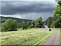
Dillichip Close
This area of housing is just to the south of Image, on the western side of the main road (visible at the far right) through Bonhill.
Carman Hill, Millburn Muir (with Image), and other nearby muirs occupy the central part of the background.
Image: © Lairich Rig
Taken: 7 Jul 2013
0.10 miles
4
Dillichip Close, Bonhill
Looking North-West Dillichip Close in Bonhill Alexandria. A housing development. The postcode is within the Leven ward, which is in the Constituency of West Dunbartonshire. In the background is the Carman Hill.
Image: © George Rankin
Taken: 6 Aug 2019
0.10 miles
5

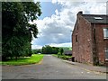
Steps leading up to Nobleston
The steps lead up from Stirling Road. The large area of housing on the hillside is divided into several areas; the part at the top of the steps is Nobleston, derived from the older designation Bonhill-Noble; for example, a retour of Charles II speaks of the lands of "Bonyle Noble alias Noblestoune" (*).
There was also a Bonhill-Napier and a Bonhill-Lindsay; they are mentioned in the same retour (as "Bonyle Naiper" and "Bonyle Lindsay"). Each of the three lands was named after the family who held it. According to page 152 of Donald MacLeod's "Historic Families ... of the Lennox" (1891), Bonhill-Noble was in the hands of the Nobles of Ardardan, a family prominent in the area.
As is explained at Image, the name Bonhill-Napier refers to the Napiers of Kilmahew. Finally, the name Bonhill-Lindsay reflects the fact that Patrick de Lindsay had been granted lands in Bonhill by Malcolm, Earl of Lennox (early fourteenth century).
(*) The retour can be found on pages 100-102 of the Lennox Cartulary ["Cartularium Comitatus de Levenax, etc." (1833), Maitland Club Edition], a collection of charters in medieval Latin. For the grants made to "Patricio de Lindsay", whom Malcolm created a hereditary bailie and forester of the Lennox estate, see pages 49-52 of the same work.
Image: © Lairich Rig
Taken: 5 Oct 2012
0.11 miles
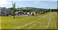
6
Dillichip Terrace
For more information on this row of buildings, and for different views, see: Image and Image
Behind the hedge on the other side of the main road is a large area of recreation ground.
Image: © Lairich Rig
Taken: 22 Sep 2008
0.12 miles
7
Dillichip Terrace
This long row of two-storey tenement buildings is 1-43 Dillichip Terrace. Dating from 1885, it is one of the few surviving examples (in this area) of housing that was originally built for workers in the local dyeing and printing industry. See also Image and Image
At the time of writing, building number 1 (at the far end) was a shop, but the remainder of the terrace was being used for housing.
Along the front of the terrace, there are several places where an original door has been partially blocked up to form a window, as is clearly evident from the resulting discontinuities in the brickwork. However, for most of them, a much more obvious sign is that the original doorsteps are still there.
As regards the terrace as a whole, compare Image, which is very similar, and which was also built to house local workers.
Image: © Lairich Rig
Taken: 26 Dec 2008
0.12 miles
8
Footpath on the A813 Stirling Road
Footpath on the A813 Stirling Road looking north towards Main Street, Dillichip and Carman Hill on the top left.
Image: © George Rankin
Taken: 6 Aug 2019
0.12 miles
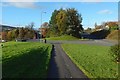
9
Access road to Dillichip Park
View looking west along the access road to Dillichip Park from Main Street, Bonhill, Dillichip Terrace to the right hand side of the photograph.
Image: © George Rankin
Taken: 6 Aug 2019
0.13 miles
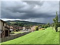
10
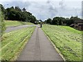
Footpath on the A813
Footpath next to the A813 looking south towards Mill Fields, Bonhill. Dillichip Close to the right hand side.
Image: © George Rankin
Taken: 6 Aug 2019
0.13 miles