IMAGES TAKEN NEAR TO
Duncryne Road, ALEXANDRIA, G83 8RY
Introduction
This page details the photographs taken nearby to Duncryne Road, G83 8RY by members of the Geograph project.
The Geograph project started in 2005 with the aim of publishing, organising and preserving representative images for every square kilometre of Great Britain, Ireland and the Isle of Man.

There are currently over 7.5m images from over14,400 individuals and you can help contribute to the project by visiting https://www.geograph.org.uk
Image Map
Images are licensed for reuse under creativecommons.org/licenses/by-sa/2.0
Notes
- Clicking on the map will re-center to the selected point.
- The higher the marker number, the further away the image location is from the centre of the postcode.
Image Listing (43 Images Found)
Images are licensed for reuse under creativecommons.org/licenses/by-sa/2.0
Image
Details
Distance
1
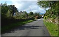
Duncryne Road
The first entrance on the left has a sign for a livestock haulage firm that is based there.
Image: © Lairich Rig
Taken: 13 Sep 2019
0.01 miles
3
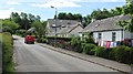
Gartocharn
Post being delivered on a minor road heading towards Duncryne.
Image: © Richard Webb
Taken: 15 Jun 2010
0.06 miles
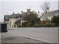
4
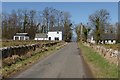
Duncryne Road
As depicted on the first-edition OS map, which was surveyed in 1860, there were quarries on both sides of the road, their near edges being roughly where the houses shown in this picture now stand.
The house to the left of the road is called Quarry Cottage. A building was depicted as standing in about the same place on the first-edition map, when the quarries were still in use; that may be why the name of that house, in particular, recalls their former presence.
Image: © Lairich Rig
Taken: 19 Apr 2013
0.08 miles
5
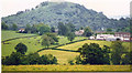
View over Gartocharn to Duncryne Hill (142m)
From the Ross Priory road.
Image: © Stanley Howe
Taken: Unknown
0.10 miles
6
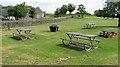
Recreation Ground, Gartocharn
At the eastern end of the village; there is a football park here too (grass).
Image: © Richard Webb
Taken: 15 Jun 2010
0.10 miles
7
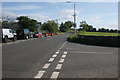
Leaving Gartocharn
Looking east on the A811 from the edge of the village.
Image: © Richard Sutcliffe
Taken: 5 Sep 2015
0.10 miles
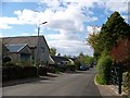
8
Gartocharn
Photograph taken from bench outside Lomond Stores shop.
Image: © Stephen Sweeney
Taken: 14 Mar 2007
0.10 miles
9
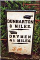
Old Milepost by the A811, Old Military Road, Gartocharn
Glasgow flat cast iron plate by the A811, in parish of Kilmaronock (West Dunbartonshire), Gartocharn, back of footpath, West of junction with Duncryne Road.
Inscription reads:-
{pointing hand->}
DUNBARTON
8 MILES
{line}
{<-pointing hand}
DRYMEN
4½ MILES
{line}
Surveyed
Milestone Society National ID: WD_DMDR08
Image: © Milestone Society
Taken: Unknown
0.10 miles
10
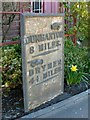
Old milestone
The presence of the stone is noted on both the 1:25000 and 1:50000 OS maps (as "MP": milepost). It was present when the first-edition OS map was surveyed in 1860, and is noted on that map (as "MS"). It is still in its original position, near the junction of the Old Military Road and Duncryne Road.
The Commissioners of Supply, and the Trustees for the Turnpike Roads, who were responsible for these milestones, appear to have favoured the spelling Dunbarton; see Image for more on that topic.
(Also with the spelling "Dunbarton": Image and Image With "Dumbarton": Image and Image)
Image: © Lairich Rig
Taken: 19 Apr 2013
0.10 miles