IMAGES TAKEN NEAR TO
Old Luss Road, ALEXANDRIA, G83 8QP
Introduction
This page details the photographs taken nearby to Old Luss Road, G83 8QP by members of the Geograph project.
The Geograph project started in 2005 with the aim of publishing, organising and preserving representative images for every square kilometre of Great Britain, Ireland and the Isle of Man.

There are currently over 7.5m images from over14,400 individuals and you can help contribute to the project by visiting https://www.geograph.org.uk
Image Map
Images are licensed for reuse under creativecommons.org/licenses/by-sa/2.0
Notes
- Clicking on the map will re-center to the selected point.
- The higher the marker number, the further away the image location is from the centre of the postcode.
Image Listing (120 Images Found)
Images are licensed for reuse under creativecommons.org/licenses/by-sa/2.0
Image
Details
Distance
1
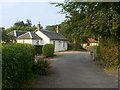
Lower Stoneymollan Road
This photograph is a view along Lower Stoneymollan Road, looking towards its junction with Old Luss Road (the building on the right stands on the far side of Old Luss Road).
See also Image, which is a view in the opposite direction.
Image: © Lairich Rig
Taken: 3 Sep 2010
0.02 miles
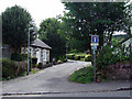
2
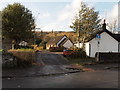
Lower Stoneymollan Road
The junction of lower Stoneymollan road with the old Luss road, the road leads to a track and footpath off over to Cardross about 8 km away.
Image: © Steve Houldsworth
Taken: 4 Nov 2018
0.04 miles
3
Old Luss Road
For a view in the opposite direction along the same street, see Image
In the present photograph, the entrance to Image is in the foreground, on the left; see also Image
Image: © Lairich Rig
Taken: 27 Nov 2010
0.04 miles
4
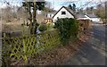
Lower Stoneymollan Road
See also Image and Image The present view is intended to draw attention to a burn that flows under the road at this point; its waters come from Image and from several other burns. Shortly before it empties into Loch Lomond, the same burn flows under a Image
Image: © Lairich Rig
Taken: 11 Mar 2013
0.05 miles
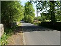
5
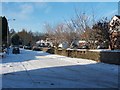
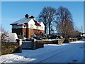
Lower Stoneymollan Road
At the junction with Old Luss Road.
Image: © Thomas Nugent
Taken: 21 Aug 2010
0.05 miles
6
Old Luss Road
The photograph was taken from beside the junction with Image
Compare Image, a view in the opposite direction along the same street; part of the same house is visible at the right-hand edge of that photo.
I have had the building described to me, accurately or not, as the former "Swiss Embassy". At any rate, this building used to be the home of Ernst Hofstetter, the Swiss Managing-Director of the British Silk Dyeing Company, whose factory was nearby. According to the book "Behind the Silken Veil" (Ian Bisland & Malcolm Lobban), he came to Balloch in the 1930s, and, with his wife Suzanne and their children, lived in this house, called Villa Suzanne.
[A certain Ernst Hofstetter, based in Sydney, Australia, was Deputy Consul General of Switzerland there until about 2010. It seems likely that he was a descendent or relative of the one mentioned above.]
Image: © Lairich Rig
Taken: 27 Nov 2010
0.06 miles
7
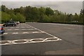
Coach Park, Loch Lomond Shores
An empty coach park on a damp Sunday afternoon at Loch Lomond Shores.
Image: © Richard Sutcliffe
Taken: 17 May 2015
0.09 miles
8
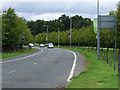
The road to Loch Lomond Shores
From the roundabout at Old Luss Road and Balloch Road.
Image: © Thomas Nugent
Taken: 21 Aug 2010
0.09 miles
9
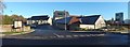
Pub restaurant at Balloch
The view is from Old Luss Road; see Image for a view from another angle.
Image: © Lairich Rig
Taken: 23 Nov 2016
0.09 miles
10
Old Luss Road
The Three Lochs Way passes the Image, and then follows a path (shown in Image), to Old Luss Road. It follows the section of road shown in the present photograph, then turns right to follow Image After that, the Three Lochs Way crosses a Image and then leads uphill, following the same route as the Stoneymollan Road – http://www.geograph.org.uk/snippet/451 – as far as a crossroads (Image). From that crossroads, the Stoneymollan Road and the Three Lochs Way follow different routes.
Image: © Lairich Rig
Taken: 2 May 2011
0.09 miles