IMAGES TAKEN NEAR TO
Arthurston Road, ALEXANDRIA, G83 8QE
Introduction
This page details the photographs taken nearby to Arthurston Road, G83 8QE by members of the Geograph project.
The Geograph project started in 2005 with the aim of publishing, organising and preserving representative images for every square kilometre of Great Britain, Ireland and the Isle of Man.

There are currently over 7.5m images from over14,400 individuals and you can help contribute to the project by visiting https://www.geograph.org.uk
Image Map
Images are licensed for reuse under creativecommons.org/licenses/by-sa/2.0
Notes
- Clicking on the map will re-center to the selected point.
- The higher the marker number, the further away the image location is from the centre of the postcode.
Image Listing (34 Images Found)
Images are licensed for reuse under creativecommons.org/licenses/by-sa/2.0
Image
Details
Distance
1
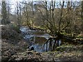
The Carrochan Burn
This is a view downstream from the point shown in Image, where the footpath to Auchincarroch Road crosses over the burn.
Image: © Lairich Rig
Taken: 25 Feb 2013
0.06 miles
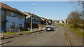
2
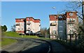
Woodburn Avenue
See Image for a view in the opposite direction from about the same place. The area of housing as a whole is called the Haldane.
Image: © Lairich Rig
Taken: 25 Feb 2013
0.07 miles
3
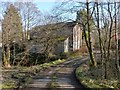
Footpath crossing the Carrochan Burn
In this picture, which was taken near Carmona Drive, the footpath crosses the Carrochan Burn in front of the right-hand side of the building. For the view downstream from there, see Image
Image: © Lairich Rig
Taken: 25 Feb 2013
0.07 miles
4
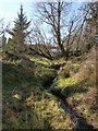
The Ruchetmoss Burn
With respect to a picture of a Image, this section of the burn is a little to the south-west (the left) of the gate that is shown there. See Image for more about the name of the burn, and for a view in the opposite direction.
Image: © Lairich Rig
Taken: 25 Feb 2013
0.07 miles
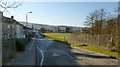
5
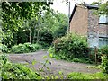
Red Craig and path
Arthurston road leading to Carmona Drive, with Red Craig house on the right hand side. The Carrochan burn runs along side Red Craig but can’t be seen in this photograph.
Image: © George Rankin
Taken: 25 Jun 2021
0.07 miles
6
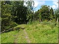
Footpath to Carmona Drive
This is a view from a little further along the path shown in Image
After entering the woods, the footpath crosses the Carrochan Burn before reaching Carmona Drive.
Image: © Lairich Rig
Taken: 13 Aug 2010
0.07 miles
7
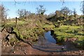
The Ruchetmoss Burn
The same section of burn is shown, viewed in the opposite direction, in Image On the left, in the present picture, and leading past the wooden post, is the footpath that is referred to in the end-note.
For most of the length of the footpath, the Ruchetmoss Burn runs parallel to it, just to its south. "Ruchetmoss Burn: this small burn is named from its junction with the Carrochan Burn at Arthurston Mill to the parish road at 22 chains east of the same" [OS Object Name Book (1890s)].
In this area, Roy's Military Survey of Scotland (1740s-50s) shows some buildings and enclosures, collectively labelled Rochitmoss, which is clearly the same name. I have seen the burn referred to, in local works from the early twentieth century, as the "Rough-head Moss", a reshaping of Ruchetmoss (and perhaps a bit of folk etymology).
Image: © Lairich Rig
Taken: 25 Feb 2013
0.08 miles
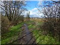
9
Carmona Drive
This is one endpoint of the route that is described in the end-note; the footpath enters the Haldane at this point on Carmona Drive.
For the other endpoint of the route, see Image
Image: © Lairich Rig
Taken: 25 Feb 2013
0.09 miles
10
Woodburn Avenue
Image is on the right. In the area in the right foreground, with trees in it, the Carrochan Burn – http://www.geograph.org.uk/tagged/the+Carrochan+Burn – enters the park.
See Image for a view in the opposite direction from about the same place. The area of housing as a whole is called the Haldane.
The spire near the far end of the road is that of Image
Image: © Lairich Rig
Taken: 25 Feb 2013
0.12 miles