IMAGES TAKEN NEAR TO
ALEXANDRIA, G83 8NB
Introduction
This page details the photographs taken nearby to G83 8NB by members of the Geograph project.
The Geograph project started in 2005 with the aim of publishing, organising and preserving representative images for every square kilometre of Great Britain, Ireland and the Isle of Man.

There are currently over 7.5m images from over14,400 individuals and you can help contribute to the project by visiting https://www.geograph.org.uk
Image Map
Images are licensed for reuse under creativecommons.org/licenses/by-sa/2.0
Notes
- Clicking on the map will re-center to the selected point.
- The higher the marker number, the further away the image location is from the centre of the postcode.
Image Listing (13 Images Found)
Images are licensed for reuse under creativecommons.org/licenses/by-sa/2.0
Image
Details
Distance
1
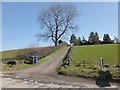
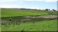
Track to the Shanacles
The name Shanacles is thought to represent the Gaelic "seann eaglais" (old church); the idea finds support in the fact that there is a synonymous "Old Kirk" (Image) about 500 metres to the south.
There is no trace of an old church here, and both of these names are thought to be referring instead to an ancient burial ground, a Bronze Age cemetery that was located in this area [see Simon Taylor's chapter in the book "Changing Identities, Ancient Roots: the History of West Dunbartonshire from Earliest Times"].
From the eighteenth century down to recent times, various cists and funerary urns have been found near here, some containing ashes, others containing bones.
Image: © Lairich Rig
Taken: 19 Apr 2013
0.03 miles
2
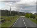
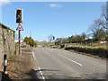
The Old Military Road
The old military road (A811) between Balloch and Gartocharn.
Image: © David Dixon
Taken: 16 Apr 2012
0.07 miles
3
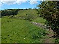
Remains of a farm track
The view is from the roadside. From there I noticed the raised course of a former track; it hugs the near side of the dry-stone wall that recedes from view. The track is depicted on the first-edition OS map (surveyed in 1859), but not on any later maps.
The track was 160 metres long. There is an old gate in the roadside wall at this end of it, and another old gate in a wall at the other end (too distant to be visible in this picture). As the map shows, this former track is almost opposite a present-day Image
Image: © Lairich Rig
Taken: 14 Jun 2019
0.13 miles
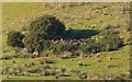
5
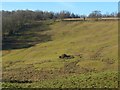
Wetland, Blairlusk
A wetland hollow beside the Military Road.
Image: © Richard Webb
Taken: 15 Jun 2010
0.14 miles
6
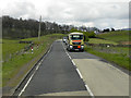
Cattle crossing
These lights, to warn of cattle crossing Stirling Road, are at Ashfield Farm. See Image; the sign visible there indicates that this crossing is 130 yards ahead.
Image: © Lairich Rig
Taken: 19 Apr 2013
0.18 miles
7
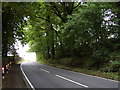
Dense trees by the A811
Near Ashfield House.
Image: © Stephen Sweeney
Taken: 30 Aug 2007
0.18 miles
8

Old Milepost by the A811, Old Military Road, north east of Balloch
Glasgow flat cast iron post by the A811, in parish of Kilmaronock (West Dunbartonshire), opposite Ashfield House, back of verge in thick vegetation, East side of road.
Inscription reads:-
{hand->}
DUNBARTON
6 MILES
{line}
{<-hand}
DRYMEN
6½ MILES
Surveyed
Milestone Society National ID: WD_DMDR06
Image: © Milestone Society
Taken: Unknown
0.23 miles
9
The site of a bomb crater
The present view, from the Stirling Road, is for context only. The crater itself is just below the centre of the picture, with gorse in an arc around its south-eastern side, and with a single larger bush on the west.
Click on the end-note title for more views, including some taken on a follow up visit to the crater itself (see Image for the circumstances of that visit).
Image: © Lairich Rig
Taken: 26 Jan 2018
0.25 miles
10
Bomb crater near Ashfield Farm
First of all, my thanks to the farmer at Ashfield for kindly taking the time to point out the site to me, and for telling me more about the appearance of the crater itself. Like the context view linked below, this is a view from a distance (specifically, from beside the main road). The farmer was quite happy for me to make a follow-up visit to the crater itself later in the year, when the ground would be more suitable for walking on: see Image
For a context view from a distance, see Image Click on the end-note title for other views, including those taken on the later visit.
Although it is filled with stones, this feature does not have the appearance of an old quarry pit. A quarry in this very visible location would, despite its small size, have been sufficiently prominent to be marked on old OS maps. Later on the same day I did come across old quarries of similar or smaller size, in much more out-of-the-way places, that, as I later determined, were marked on those maps; see, for example, Image
This crater seems to be isolated, not part of a group. The largest collection of bomb craters in the wider area is to be found about three miles to the SSE, on Dumbarton Muir: see https://www.geograph.org.uk/snippet/648
Image: © Lairich Rig
Taken: 26 Jan 2018
0.25 miles