IMAGES TAKEN NEAR TO
Dalvait Gardens, ALEXANDRIA, G83 8LW
Introduction
This page details the photographs taken nearby to Dalvait Gardens, G83 8LW by members of the Geograph project.
The Geograph project started in 2005 with the aim of publishing, organising and preserving representative images for every square kilometre of Great Britain, Ireland and the Isle of Man.

There are currently over 7.5m images from over14,400 individuals and you can help contribute to the project by visiting https://www.geograph.org.uk
Image Map
Images are licensed for reuse under creativecommons.org/licenses/by-sa/2.0
Notes
- Clicking on the map will re-center to the selected point.
- The higher the marker number, the further away the image location is from the centre of the postcode.
Image Listing (208 Images Found)
Images are licensed for reuse under creativecommons.org/licenses/by-sa/2.0
Image
Details
Distance
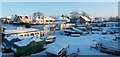
1
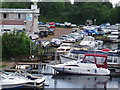
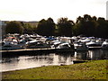
Loch Lomond Marina
View of Marina building and boats taken from the road bridge over the river Leven. 6th June 2009 3.00p.m.
Image: © Gordon Dowie
Taken: 6 Jun 2009
0.04 miles
2
Lomond Road Balloch east of Leven bridge
Image: © John Firth
Taken: 26 Jul 2012
0.05 miles
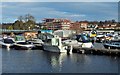
3
Balloch: the marina from across the Leven
Looking across the River Leven towards the lines of boaths moored in the marina.
Image: © Chris Downer
Taken: 25 Sep 2010
0.06 miles
4
Balloch: boats in the marina
Looking across the River Leven as the boats moored in the marine catch today's unending sunlight.
Image: © Chris Downer
Taken: 25 Sep 2010
0.06 miles
5
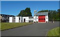
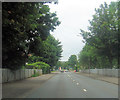
Balloch Fire Station
The view is from Lomond Road. For another contributor's earlier picture, see Image
Image: © Lairich Rig
Taken: 20 Sep 2019
0.07 miles
6
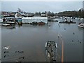
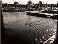
Riverside, Balloch
The area was flooded after weeks of rain. The orange line below the water, right of centre, is a brick wall, intended to prevent flooding; the river should be to the right of that wall. The view is from Balloch Bridge (Image).
For earlier views of the same area, without the flooding, see Image and Image
Image: © Lairich Rig
Taken: 5 Feb 2016
0.08 miles
7
Construction at Balloch
Image can be seen on the left. The area on the right, on the other side of the Leven, is shown in Image (in more wintry conditions), and also in Image
The construction work in the background is taking place on a gap site, which had earlier been the site of a petrol station. The development is to consist of flats and retail units. The completed building is shown in Image; compare Image, an equivalent earlier picture taken before that building appeared.
Image: © Lairich Rig
Taken: 19 Nov 2014
0.08 miles
8
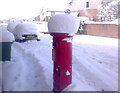
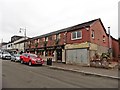
Postbox Dalvait Rd, Balloch
This Postbox was on the pavement outside the Well Pharmacy on Dalvait Rd, Balloch. It was removed (2020) after the Post Office was moved from Dalvait Rd to the Co-op Store, Carrochan Rd, Balloch.
Image: © Pete Marrison
Taken: 1 Mar 2018
0.09 miles
9
Riverside, Balloch
The photograph was taken about an hour before sunset. Visible at the extreme right is a building associated with Image For another view of this area (in a part of Balloch called Riverside), see Image
Image: © Lairich Rig
Taken: 7 Dec 2010
0.09 miles