IMAGES TAKEN NEAR TO
Levenhowe Place, ALEXANDRIA, G83 8LR
Introduction
This page details the photographs taken nearby to Levenhowe Place, G83 8LR by members of the Geograph project.
The Geograph project started in 2005 with the aim of publishing, organising and preserving representative images for every square kilometre of Great Britain, Ireland and the Isle of Man.

There are currently over 7.5m images from over14,400 individuals and you can help contribute to the project by visiting https://www.geograph.org.uk
Image Map
Images are licensed for reuse under creativecommons.org/licenses/by-sa/2.0
Notes
- Clicking on the map will re-center to the selected point.
- The higher the marker number, the further away the image location is from the centre of the postcode.
Image Listing (97 Images Found)
Images are licensed for reuse under creativecommons.org/licenses/by-sa/2.0
Image
Details
Distance
1
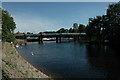
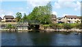
Road Bridge over the River Leven in Balloch, Scotland.
This is a road bridge over the River Leven that runs out of the south end of Loch Lomond in Balloch, Scotland.
Image: © andy
Taken: 4 Jul 2005
0.06 miles
2
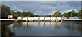
The northern side of the barrage at Balloch
For further details, and a wider view of this structure (from the south), see: Image
Image: © Lairich Rig
Taken: 21 Sep 2008
0.07 miles
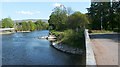
3
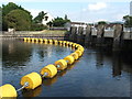
The barrage at Balloch
This is one of a total of eleven crossings of the River Leven, of which three cannot be used by pedestrians: (1) this barrage, which has a footpath on top behind locked gates; (2) the Black Bridge (Image), which had long been closed when this picture was taken, and which was later removed altogether; and (3) the railway bridge at Dumbarton.
The eleven crossings therefore consist of ten bridges, and this barrage, which is not a bridge.
Speaking of the Central Water Development Board, and their use of Loch Lomond in providing water for the central belt of Scotland, John Mitchell's book "Loch Lomondside" (in the New Naturalist series) mentions this barrage:
"The Loch Lomond Water Scheme, which involved controlling the natural discharge from the loch by means of a barrage across the River Leven, was officially opened on 29 June 1971. Through its pumping station at Ross Priory on the loch's southern shore, the Board was given the authority to abstract up to 455 megalitres (100 million gallons) of water per day, providing the level of the loch does not fall below 6.7 m (22 ft) OD".
The barrage has seven separate gates, hinged at the base; they can be raised by electrically-operated pulleys and steel ropes. Though designed to be controlled by a computer system, the barrage is instead operated manually [Reference: the paper "Water management of Loch Lomond – What does the future hold?" by Owen Bramwell (Scottish Water, Edinburgh)].
["OD" here refers to a standard, called Ordnance Datum Newlyn, which the Ordnance Survey use to express heights in Britain.]
See also: Image
Image: © Lairich Rig
Taken: 17 Oct 2007
0.07 miles
4
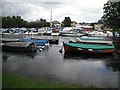
River Leven, Balloch
Full of moored boats that are used on Loch Lomond.
Image: © Richard Webb
Taken: 4 Mar 2009
0.08 miles
5
Burn flowing into the River Leven
The waters formed by the confluence of the Carrochan Burn and Ballagan Burn empty into the river here. The houses to either side are alongside Levenhowe Road (left) and Honeysuckle Lane (right); for the latter, see Image
Image: © Lairich Rig
Taken: 2 May 2011
0.08 miles
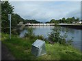
6
Lade intake near Rosshead
The intake is near the centre of the image, where a stone structure (a "skimmer" – compare Image), projecting into the River Leven, serves to direct some of the river's flow into the lade. The lade was built to serve the nearby dye works; for the latter, see Image and Image
For a view along the lade from its intake, see Image and Image
Image: © Lairich Rig
Taken: 2 May 2011
0.10 miles
7
The mounting for a new information panel
Some panels on the Leven Valley Heritage Trail, installed about 30 years earlier, had recently been replaced after having long been in poor condition. One of those replacements is shown at Image
As also mentioned there, some entirely new panels were added to the trail, these being mounted on stainless steel structures of the same size and shape as the original stone ones; as the present picture shows, the mountings appeared before the panels did. The River Leven and Image appear in the background.
Image: © Lairich Rig
Taken: 22 Aug 2019
0.10 miles
8
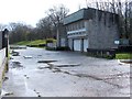
Fisherwood Pumping Station
The pumping station, shown from a different angle in Image, is located at the western side of a barrage across the River Leven: http://www.geograph.org.uk/photo/972918
Just to the north are the buildings of Image and of the Image The wooded slopes behind and to the right of the pumping station are Boathouse Wood (on the far side of the pumping station), and Fishers Wood (on the near side).
The short stretch of road shown in the image is shared with NCN Cycle Route 7, and provides access to the buildings mentioned above and to the many boats that are moored in the river near this point. At roughly the point where the green slope in the background comes to an end, the road turns aside from the River Leven and leads into Rosshead.
Image: © Lairich Rig
Taken: 27 Mar 2009
0.10 miles
9
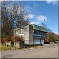
Fisherwood Pumping Station
The same building is shown from a different angle in Image, and from a distance in Image
Fishers Wood is the area of woodland in the right background of the present photograph; the buildings of the Image are located between those woods and the River Leven.
Image: © Lairich Rig
Taken: 19 Apr 2013
0.10 miles
10
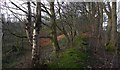
Approaching a disused gravel pit in Boathouse Wood
The view is from near the eastern edge of the woods. To the right, beside the River Leven, is a path that is also part of a cycle route. A low but clearly visible earthen ridge is shown receding from view; to its left is a large expanse of lower ground. That lower ground forms a wide, deep, straight hollow that leads NNW and which opens out at its far end to form a still wider pit: Image See that link for the representation of this feature on some large-scale mapping.
The low ground to the left of the ridge was therefore the way of getting to the gravel pit, and of getting material out.
The boathouse that gave these woods their name is long gone, but it was not far away, at about Image
Image: © Lairich Rig
Taken: 19 Jan 2020
0.12 miles