IMAGES TAKEN NEAR TO
McFarlane Drive, ARROCHAR, G83 7BD
Introduction
This page details the photographs taken nearby to McFarlane Drive, G83 7BD by members of the Geograph project.
The Geograph project started in 2005 with the aim of publishing, organising and preserving representative images for every square kilometre of Great Britain, Ireland and the Isle of Man.

There are currently over 7.5m images from over14,400 individuals and you can help contribute to the project by visiting https://www.geograph.org.uk
Image Map
Images are licensed for reuse under creativecommons.org/licenses/by-sa/2.0
Notes
- Clicking on the map will re-center to the selected point.
- The higher the marker number, the further away the image location is from the centre of the postcode.
Image Listing (83 Images Found)
Images are licensed for reuse under creativecommons.org/licenses/by-sa/2.0
Image
Details
Distance
1
Bus stop on Church Road
Only about four buses a day on a service from Carrick Castle to Helensburgh actually use this stop.
Image: © Gerald England
Taken: 21 Mar 2017
0.04 miles
2
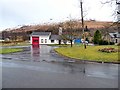
Arrochar Fire Station
The station opened in January 1982 http://www.graemekirkwood.co.uk/SFB/F14.htm
Image: © Gerald England
Taken: 21 Mar 2017
0.04 miles
4
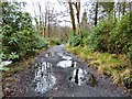
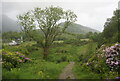
Three Lochs Way near Tighness
The path is as in Image, but the present view is from further along it. See Image for a view downhill from roughly the same place.
This part of the path is not shown on the 1:25000 map, but the fence it follows is. Not much further ahead (uphill), the path changes direction to head SSW; that part of the route is depicted on the map: Image
Image: © Lairich Rig
Taken: 29 Jun 2014
0.06 miles
5
A pot-holed footpath
A path leading from Church Road Image into the back of the Claymore Hotel.
Image: © Gerald England
Taken: 21 Mar 2017
0.08 miles
6
Path to Tighness
The path is the one shown in Image, but the present view is in the opposite direction, and taken from a little further up the slope. The top of Image can be seen on the right. Part of Loch Long is visible at the far right.
Image: © Lairich Rig
Taken: 29 Jun 2014
0.08 miles
7
Three Lochs Way at Tighness
A branch of the Way ascends from the side of the loch, first by means of Image, and then by this path, to meet the main route of the Three Lochs Way higher up the slope, on the other side of the railway line (see the map).
See Image for a view in the opposite direction from a little further along the path.
Image: © Lairich Rig
Taken: 29 Jun 2014
0.08 miles
8
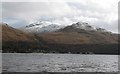
Across Loch Long to Tighness
The view across to Tighness with Tullich Hill beyond.
Image: © Gordon Hatton
Taken: 28 Mar 2008
0.10 miles
9
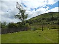
Arrochar Link Path
Joins the Three lochs way with the village of Arrochar.
Image: © Ian S
Taken: 11 Jun 2022
0.10 miles
10
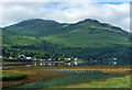
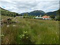
Arrochar
Seen from across the head of Loch Long. The peak on the right is Monadh Tighe na Laraich (447m) and that on the left is Ben Reoch (660m).
Image: © Bill Kasman
Taken: 26 Jun 2016
0.10 miles