IMAGES TAKEN NEAR TO
St. Rhonans Lane, ALEXANDRIA, G83 0SU
Introduction
This page details the photographs taken nearby to St. Rhonans Lane, G83 0SU by members of the Geograph project.
The Geograph project started in 2005 with the aim of publishing, organising and preserving representative images for every square kilometre of Great Britain, Ireland and the Isle of Man.

There are currently over 7.5m images from over14,400 individuals and you can help contribute to the project by visiting https://www.geograph.org.uk
Image Map
Images are licensed for reuse under creativecommons.org/licenses/by-sa/2.0
Notes
- Clicking on the map will re-center to the selected point.
- The higher the marker number, the further away the image location is from the centre of the postcode.
Image Listing (152 Images Found)
Images are licensed for reuse under creativecommons.org/licenses/by-sa/2.0
Image
Details
Distance
1
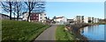
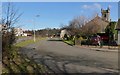
Construction at Riverside
The area is called Riverside. The large building left of centre is being built on what was previously a grassy area in front of Image (visible at the far left in the present photograph). The Image are on the right.
As for the buildings that were under construction when this picture was taken, they are in Leven Street. According to a plaque on a stone at the north-western end of the development, this area of new housing was officially opened by Keith Brown MSP, Minister for Housing and Transport, on the 6th of June, 2012.
See also Image, taken when construction was complete.
Image: © Lairich Rig
Taken: 30 Mar 2012
0.03 miles
2
Leven Street housing
The large building shown left of centre is one of several that had recently been built on Leven Street (the others are behind it). They were completed just a few months before this picture was taken, and they were officially opened in June of 2012. Compare Image, which was taken while construction was in progress.
The section of track in the right foreground is a footpath and cycle route that follows the western bank of the River Leven; it continues along the road on the right.
Image: © Lairich Rig
Taken: 5 Oct 2012
0.03 miles
3
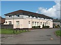
Millburn Mews
The name "Mews" often suggests the former presence of stables in an area. However, this building, Millburn Mews (122 Leven Street), was previously the local Buroo (cf. Image); it has since been converted into housing.
In this photograph, two white doors are visible on the front of the building; above the door on the right, the date 1936 appears, along with the royal cipher of Edward VIII: Image
See Image for another view of the building, and Image for a later development nearby.
Image: © Lairich Rig
Taken: 4 Aug 2008
0.05 miles
4
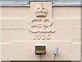
Millburn Mews - Royal cipher of Edward VIII
These details appear above one of the front doors of Millburn Mews.
For more information, and for a view of the building itself, see Image
Image: © Lairich Rig
Taken: 13 Mar 2009
0.05 miles
5

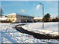
Thomas Street flats
Riverside flats, Alexandria.
Image: © Richard Webb
Taken: 1 Sep 2009
0.05 miles
6
Glebe Gardens
At this point, the path shown in Image meets Glebe Gardens (the road of that name); the area as a whole is called the Glebe.
Image – http://www.geograph.org.uk/snippet/7986 – is on the right, and the eastern end of the Image, which is the endpoint of this route, can be seen on the left, behind the Image
Image: © Lairich Rig
Taken: 25 Feb 2013
0.05 miles
7
Millburn Mews
See Image for another view of the building (formerly the local buroo, now converted into housing), and for further details.
The present photograph additionally shows an open area opposite the building. Housing was later built on that space: compare Image and Image
Image: © Lairich Rig
Taken: 29 Nov 2010
0.05 miles
8
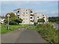
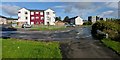
High flats at Riverside
These flats are located in the appropriately-named Riverside area; the nearer two stand on Thomas Street, and the other on Angus Street. The lower buildings at the left-hand edge of the picture are part of St Ronan's Lane.
National Cycle Network route 7 is visible in the foreground.
For a similar view about a year later, see Image
Image: © Lairich Rig
Taken: 21 Sep 2008
0.06 miles
9
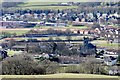
Bonhill Bridge
Bonhill Church Vale of Leven FC ground and Vale of Leven Academy
Image: © Eddie Mackinnon
Taken: 6 Mar 2005
0.06 miles
10
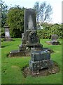
Bonhill Parish Kirkyard
See Image for the church itself.
The tall memorial is for John McGlashan, who died at Millburn; Mary Ferrie his wife, who died at Renton; and their family, one of whom (Alexander McGlashan) was minister of the parish of Lanark for 25 years.
The smaller memorial in the foreground bears the following text (from Longfellow):
"There is no death. What seems so is transition.
This life of mortal breath
is but a suburb of the life Elysian,
whose portal we call death."
Image: © Lairich Rig
Taken: 5 Oct 2012
0.07 miles