IMAGES TAKEN NEAR TO
Alexander Street, ALEXANDRIA, G83 0PQ
Introduction
This page details the photographs taken nearby to Alexander Street, G83 0PQ by members of the Geograph project.
The Geograph project started in 2005 with the aim of publishing, organising and preserving representative images for every square kilometre of Great Britain, Ireland and the Isle of Man.

There are currently over 7.5m images from over14,400 individuals and you can help contribute to the project by visiting https://www.geograph.org.uk
Image Map
Images are licensed for reuse under creativecommons.org/licenses/by-sa/2.0
Notes
- Clicking on the map will re-center to the selected point.
- The higher the marker number, the further away the image location is from the centre of the postcode.
Image Listing (140 Images Found)
Images are licensed for reuse under creativecommons.org/licenses/by-sa/2.0
Image
Details
Distance
1
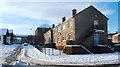
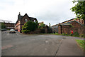
Susannah Street, Alexandria
Susannah Street is on the left. The picture was taken from the corner where it meets James Street.
Image: © Lairich Rig
Taken: 29 Nov 2010
0.04 miles
2
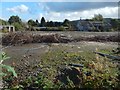
Waste ground by Lennox Street, Alexandria
According to nearby signage, it is to let, for storage. It is bounded by Lennox Street to the west, Alexander Street to the south, North Street to the north (the entrance is on that side), and by the railway line to the east.
(I have specified "Lennox Street, Alexandria" in the title because there is, 2.5 km to the south, another Lennox Street, in Renton.)
Image: © Lairich Rig
Taken: 29 Sep 2017
0.04 miles
3
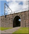
Railway underpass
Image: © Lairich Rig
Taken: 19 Apr 2013
0.06 miles
4
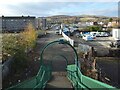
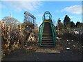
North Street from the railway footbridge
From the foot of the steps (Image), North Street continues ahead for about 320 metres before meeting Main Street. On the other side of Main Street, Hill Street continues on more or less the same line.
Overton Muir (Image) occupies the central part of the background, with Bromley Muir (Image) to its right (NNW).
Like Main Street, North Street was in existence when the first-edition OS map was surveyed in 1860. Hill Street, on the other side of Main Street, had not yet been built.
North Street was at that time appropriately named, being the northern limit of development in this part of Alexandria.
The railway footbridge from which this picture was taken was also present in 1860. The view from there would then have shown gasworks to the right (north) of the road, where there is now a garage. There is still a gas governor there.
The eastern side of the footbridge, the side behind the photographer, is shown in Image
Image: © Lairich Rig
Taken: 19 Nov 2020
0.06 miles
5
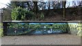
New mural beside the River Leven
This is just part of a much longer mural. For context, see Image, an earlier picture. This detail from the mural is on the section of white wall that is at the back in the earlier picture.
See Image for another detail.
Image: © Lairich Rig
Taken: 13 Mar 2019
0.07 miles
6
New mural beside the River Leven
This is just one part of a longer mural; this section shows Image and Image The section out of shot to the right shows Robert the Bruce and a birlinn. The section out of shot to the left shows a fisherman, a heron, Image, and some of the wildlife sustained by the river itself.
For another section, to the photographer's left, see Image For context, see Image, an earlier picture; the section of mural shown in the present picture is on the section of white wall that is, in the earlier picture, just to the left of the red and blue information panels.
See Image for a more distant view of the same area from the other side, likewise taken before the mural was painted.
Image: © Lairich Rig
Taken: 13 Mar 2019
0.07 miles
7
Footbridge over the railway line
On this side, North Street leads to the foot of the steps; see Image, a view back from the top of these steps.
The other side is shown in Image On that side, a road (Image) leads, depending on the direction chosen, either to India Street or to Antartex and Loch Lomond Distillery: Image / Image / Image
Image: © Lairich Rig
Taken: 19 Nov 2020
0.07 miles
8
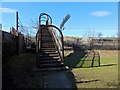
Footbridge over the railway line
On the far side of the bridge (Image), and continuing in the same direction, is North Street, Alexandria: Image
On this side, behind the photographer, is the northern end of India Street (the end that is nearest the photographer's position in Image).
Also behind the photographer, and separated from India Street by some bollards, is the start of a road that leads past the bonded warehouses of Image and the entrance of Image (Image / Image) before meeting Bowie Road.
For that road, see Image (a view to the right from the point from which the present picture was taken), and Image
Image: © Lairich Rig
Taken: 7 Mar 2016
0.08 miles
9
Turkey Red Dye Works Gates Alexandria
India street and Turkey Red Dye Works Gates Alexandria
Image: © Eddie Mackinnon
Taken: 11 Jul 2006
0.08 miles
10
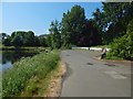
Beside the River Leven
For a view in the opposite direction from about the same place, see Image
In the foreground there is a small car park and the part of the River Leven near Image In front of the houses in the left background is the raised line of the railway. There are some pedestrian tunnels below that line.
Image: © Lairich Rig
Taken: 6 Jun 2018
0.08 miles