IMAGES TAKEN NEAR TO
Main Street, ALEXANDRIA, G83 0NU
Introduction
This page details the photographs taken nearby to Main Street, G83 0NU by members of the Geograph project.
The Geograph project started in 2005 with the aim of publishing, organising and preserving representative images for every square kilometre of Great Britain, Ireland and the Isle of Man.

There are currently over 7.5m images from over14,400 individuals and you can help contribute to the project by visiting https://www.geograph.org.uk
Image Map
Images are licensed for reuse under creativecommons.org/licenses/by-sa/2.0
Notes
- Clicking on the map will re-center to the selected point.
- The higher the marker number, the further away the image location is from the centre of the postcode.
Image Listing (135 Images Found)
Images are licensed for reuse under creativecommons.org/licenses/by-sa/2.0
Image
Details
Distance
1

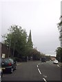
Upper Bridge Street Alexandria
Upper Bridge Street Alexandria from the Junction of Middleton Street and Queen Street
Image: © Eddie Mackinnon
Taken: 23 Mar 2007
0.04 miles
2
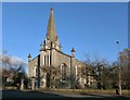
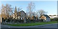
Former Alexandria Parish Church
This is a view from the other side of Main Street.
The main gate is between two pillars. A war memorial used to stand in the kirkyard, just beyond and to the left of that gate, but it now stands beside the present-day Image: see Image
Image: © Lairich Rig
Taken: 27 Nov 2012
0.05 miles
4
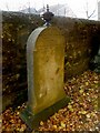
Memorial to Archibald Ferguson
The stone is set beside the southern boundary wall of Image The inscription names Archibald Ferguson himself (he was a painter in Dumbarton), his son David Napier Ferguson, and his wife Grace Napier. The stone is not particularly remarkable in itself, but the story of its being located here does say something about nineteenth-century Dumbarton.
Donald MacLeod, in his book "Historic Families ... of the Lennox" (1891), mentions "Three Dumbartonians" buried in this churchyard, one of whom is Archibald Ferguson, "painter, town councillor, and elder of the Parish Kirk; a decent worthy, prosperous man". The other two are William McFarlane, "grocer and proprietor in the royal burgh, an honest, plain, blunt man of the old school, and also an elder of the Kirk" (his memorial is located nearby), and Robert Lang, who worked in a coalmaster's office, and later ran a steam tug (MacLeod says that "he was a smart man, but possessed of a fiery, ungovernable temper").
MacLeod explains the reason for their being buried here; they had been parties to the expensive litigation connected to the shutting down of the old kirkyard of Dumbarton Parish Church (see http://www.geograph.org.uk/article/Dumbarton-Cemetery#closing-the-parish-churchyard where this is discussed at length; the three Dumbarton men were opposed to the closure of the old Dumbarton kirkyard), and, as MacLeod puts it, "rather than lie within the borders of its new and beautiful cemetery, they preferred that their mortal remains should decay and be resolved into dust among 'unco folk'". He follows it up with a remark that "the ruling spirit, in each of the above cases, was strong in death".
[That last remark sounds, to me, like a snide comment (those who wished to be buried elsewhere are, in effect, being described as very stubborn). If it is, the reason lies in the politics of Dumbarton life at that time. There was an underlying division into two factions, one of them consisting of the Denny family and their supporters, and another that was opposed to their activities. In the resulting disputes, MacLeod was very much on the Denny side; in fact, he was personally involved in some of the resulting litigation. As a result, a bias is sometimes apparent in his works, and it is as well to be aware of this (though it does not detract from the historical value of his books). For example, the Dennys had been behind the creation of the new Dumbarton Cemetery, which MacLeod described in glowing terms (as quoted above), and they were also behind the moves to have Dumbarton's old parish churchyard closed to new burials. See http://www.geograph.org.uk/article/Dumbarton-Cemetery#closing-the-parish-churchyard where these factional divisions are discussed under the subheading "The Chronicles of Gotham".]
Image: © Lairich Rig
Taken: 5 Nov 2012
0.05 miles
5
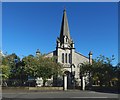
Former Alexandria Parish Church from Main Street
Image: © John Firth
Taken: 14 May 2014
0.05 miles
6
Former Alexandria Parish Church
This picture was taken from Church Street. For a view of the church from the other side, see Image
The present photograph also shows the kirkyard (Image) and its boundary wall. The structure that is built into the eastern wall is Image
The houses at the extreme right are on Image
Image: © Lairich Rig
Taken: 27 Nov 2012
0.06 miles
7
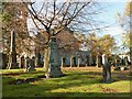
Alexandria Parish Churchyard
The picture was taken from the south-eastern corner of the churchyard. The disused church itself is in the background.
Image: © Lairich Rig
Taken: 5 Nov 2012
0.06 miles
8
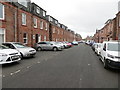
Middleton Street in Alexandria
Looking southward.
Image: © Peter Wood
Taken: 25 Jul 2020
0.06 miles
9
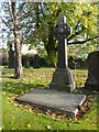
The Ferguson Memorials
The memorials in the foreground are in the north-eastern part of Image The cross commemorates John Hamilton Ferguson, who died at Crosshill, Glasgow, on the 28th of September 1888. The plaque in front of it commemorates the Fergusons of Napierston, and is shown separately: Image
Image: © Lairich Rig
Taken: 5 Nov 2012
0.07 miles
10
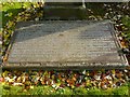
Ferguson of Napierston Memorial
Image: © Lairich Rig
Taken: 5 Nov 2012
0.07 miles