IMAGES TAKEN NEAR TO
Mitchell Way, ALEXANDRIA, G83 0LW
Introduction
This page details the photographs taken nearby to Mitchell Way, G83 0LW by members of the Geograph project.
The Geograph project started in 2005 with the aim of publishing, organising and preserving representative images for every square kilometre of Great Britain, Ireland and the Isle of Man.

There are currently over 7.5m images from over14,400 individuals and you can help contribute to the project by visiting https://www.geograph.org.uk
Image Map
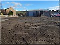
Images are licensed for reuse under creativecommons.org/licenses/by-sa/2.0
Notes
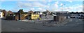
- Clicking on the map will re-center to the selected point.
- The higher the marker number, the further away the image location is from the centre of the postcode.
Image Listing (145 Images Found)
Images are licensed for reuse under creativecommons.org/licenses/by-sa/2.0
Image
Details
Distance
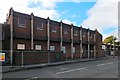
1
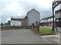
Mitchell Way, Alexandria
Compare an earlier picture: Image The building on the left in that view has been demolished; see also Image
Image: © Lairich Rig
Taken: 21 Aug 2016
0.02 miles
2
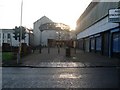
Mitchell Way, Alexandria
Main shopping street in the town centre.
Image: © Stephen Sweeney
Taken: 6 Dec 2008
0.04 miles
3
Medical Centre, Bank Street, Alexandria
Image: © Elliott Simpson
Taken: 1 Jun 2013
0.04 miles
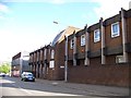
4
Mitchell Way, Alexandria
Image: © Lairich Rig
Taken: 21 Aug 2016
0.04 miles
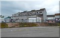
5
Medical Centre in Bank Street being demolished
Demolition of the former Image was underway when this picture was taken. For views from the back, see Image and Image
For a later view, see Image
Image: © Lairich Rig
Taken: 23 Oct 2016
0.04 miles
6
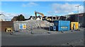
Medical Centre in Bank Street being demolished
The view is from the part of the road that appears at the far right in Image Much of the facade on Bank Street was still intact: Image
For a later view, see Image
Image: © Lairich Rig
Taken: 23 Oct 2016
0.04 miles
7
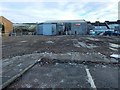
Cleared site of Medical Centre
The Medical Centre in Bank Street, Alexandria, is shown being demolished in Image / Image / Image
The view direction of the last of those pictures corresponds to that of the present picture, which is a view through the boundary fence of the site; the remains of the building itself have been cleared away.
Ahead, at the centre and on the right, are the backs of buildings on Mitchell Way.
Image: © Lairich Rig
Taken: 13 Jan 2017
0.04 miles
8
Cleared site of Medical Centre
This was the location of Bank Street Medical Centre; Bank Street is in the foreground.
An earlier and roughly equivalent view (the tree and lamp post on the right are the same ones) shows the buildings mostly intact: Image
Image: © Lairich Rig
Taken: 18 Jan 2017
0.04 miles
9
Cleared site of Medical Centre
Part of Bank Street is on the left. The buildings from centre to right are on Mitchell Way.
Image: © Lairich Rig
Taken: 27 Feb 2017
0.04 miles
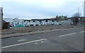
10
Medical Centre in Bank Street being demolished
As shown in Image, some of the facade on Bank Street remained intact, but work was well underway here at the back; see Image for a view from the part of the road at the far right.
For a later view, see Image
Image: © Lairich Rig
Taken: 23 Oct 2016
0.04 miles