IMAGES TAKEN NEAR TO
Overton Road, ALEXANDRIA, G83 0LJ
Introduction
This page details the photographs taken nearby to Overton Road, G83 0LJ by members of the Geograph project.
The Geograph project started in 2005 with the aim of publishing, organising and preserving representative images for every square kilometre of Great Britain, Ireland and the Isle of Man.

There are currently over 7.5m images from over14,400 individuals and you can help contribute to the project by visiting https://www.geograph.org.uk
Image Map
Images are licensed for reuse under creativecommons.org/licenses/by-sa/2.0
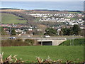
Notes
- Clicking on the map will re-center to the selected point.
- The higher the marker number, the further away the image location is from the centre of the postcode.
Image Listing (107 Images Found)
Images are licensed for reuse under creativecommons.org/licenses/by-sa/2.0
Image
Details
Distance
1

Overton Road, Alexandria
This part of the road is just downhill from the point where it goes under the bypass, as shown in Image, a view in the opposite direction from about the same point.
In the present picture, the small building on the right is Overton Pumping Station.
Image: © Lairich Rig
Taken: 23 Nov 2012
0.02 miles
2
A82 at Overton Road Alexandria
A82 at Bridge on overton Road Alexandria
Image: © Eddie Mackinnon
Taken: 23 Mar 2007
0.05 miles
3

Path to Overton Road
The path leads down, by means of steps, from the northern end of Image to Image, which crosses from left to right at the foot of the steps. The road in the background is Image; in the background of that photograph (and of the present picture) the Image can be seen.
Image: © Lairich Rig
Taken: 23 Nov 2012
0.05 miles
4
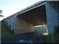
Underpass on Overton Road
The road here passes under the dual carriageway (the A82). For views of the underpass from the other side (uphill of it), see Image and Image
For a view from about the same place as the present picture, but looking downhill, away from the underpass, see Image
Image: © Lairich Rig
Taken: 29 Oct 2015
0.06 miles
5

Upper Smollett Street, Alexandria
A flight of steps (Image) leads up from Image to this point at the northern end of Upper Smollett Street.
Image: © Lairich Rig
Taken: 23 Nov 2012
0.06 miles
6
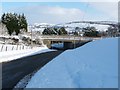
Overton Road, Alexandria
The picture was taken from near the Image Ahead, the road passes below the A82 (dual carriageway). About 180 metres beyond that underpass, Overton Road meets Image (this section of road is the last stage of a path from Millburn to Smollett Street).
For another contributor's earlier photographs showing the road and the underpass, see Image and Image
The distant background is the wooded Pappert Hill (Image), from centre to right, with Auchincarroch Hill (Image) on the left.
Previous: Image
Image: © Lairich Rig
Taken: 30 Nov 2010
0.06 miles
7
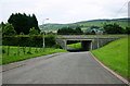
View from Overtoun Road
View from Overtoun Road looking east towards the overpass on the A82
Image: © George Rankin
Taken: 20 Jun 2007
0.08 miles
8
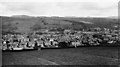
Alexandria
Old early Photograph of Alexandria taken from waterworks
Image: © Eddie Mackinnon
Taken: 28 Mar 2006
0.09 miles
9

Smollett Street, Alexandria
A prominent building, visible just right of centre, and located at the junction with Gilmour Street (Image), is the Image
Image: © Lairich Rig
Taken: 30 Nov 2010
0.10 miles
10
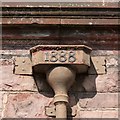
Masonic Temple: detail
Great attention to detail is evident throughout the building, even down to the individual drain-heads; this is one of several on the southern side, and, like the others, it records the year when construction began.
See Image for more information, and for a view of the building as a whole. Click on the end-note title for other images.
Image: © Lairich Rig
Taken: 5 Apr 2013
0.11 miles