IMAGES TAKEN NEAR TO
Queens Drive, ALEXANDRIA, G83 0AY
Introduction
This page details the photographs taken nearby to Queens Drive, G83 0AY by members of the Geograph project.
The Geograph project started in 2005 with the aim of publishing, organising and preserving representative images for every square kilometre of Great Britain, Ireland and the Isle of Man.

There are currently over 7.5m images from over14,400 individuals and you can help contribute to the project by visiting https://www.geograph.org.uk
Image Map
Images are licensed for reuse under creativecommons.org/licenses/by-sa/2.0
Notes
- Clicking on the map will re-center to the selected point.
- The higher the marker number, the further away the image location is from the centre of the postcode.
Image Listing (66 Images Found)
Images are licensed for reuse under creativecommons.org/licenses/by-sa/2.0
Image
Details
Distance
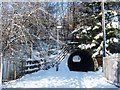
1

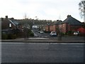
Queen's Drive, Burnbrae
The photograph was taken at the junction that is shown in the centre of Image For example, a building shown on the left in that photograph is visible on the right in this one.
As explained at the link just given, Queen's Drive begins here, although it is continuous with Hillside Avenue (Image, behind the photographer); the name of the road simply changes at this point.
The green sign on the left indicates the course of a Image
Image: © Lairich Rig
Taken: 30 Nov 2010
0.02 miles
2
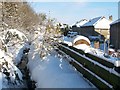
The Mill Burn
The burn, which gives the Millburn area its name, is visible on the left, its surface frozen.
The picture was taken from beside an Image; specifically, it was taken from the railings that are on the right, on the near side of the underpass, in that photograph. For a wider view, see Image; the long fence that is visible on the right in that image is the one that is shown in the present photograph.
The back gardens on the right are those of the houses on Image
Image: © Lairich Rig
Taken: 30 Nov 2010
0.03 miles
3

Millburn Road, Burnbrae
Millburn Road is in the middle distance, receding from the photographer's viewpoint. At its near end, another road, crossing from left to right, is also visible; that road changes its name at this junction with Millburn Road: it is called Queen's Drive on the left (Image), but Hillside Avenue (Image) on the right.
The path in the foreground of the photograph is part of a route between Millburn and Image For a view in the opposite direction over that part of the path, see Image
Visible beyond the far end of Millburn Road is part of the new Image The broad, wooded hill behind it on the skyline is Pappert Hill (Image).
Image: © Lairich Rig
Taken: 30 Nov 2010
0.05 miles
4
Tunnel under A82
East end of Tunnel under A82 at Millburn Road
Image: © Eddie Mackinnon
Taken: 23 Mar 2007
0.05 miles
5
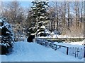
Path to Vale of Leven Cemetery
Compare Image, where the same section of path, viewed in the opposite direction, is shown in the foreground. See also Image, where a signpost, pointing to the left, indicates this path.
An Image is visible not far ahead. Beyond the underpass, the route to the cemetery turns off to the right, while a different route, leading uphill towards Image, continues straight ahead.
Previous: Image
Next: Image
Image: © Lairich Rig
Taken: 30 Nov 2010
0.06 miles
6
Wylie Avenue, Alexandria
Looking west from Main Street.
Image: © Stephen Sweeney
Taken: 6 Dec 2008
0.07 miles
7
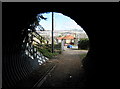
Underpass leading below the A82
This is a closer view of the underpass that is shown in Image Image flows below the footpath, from right to left, on the near side of the underpass.
For earlier photographs, taken by another contributor in a different season, see Image, Image, and Image
Previous: Image
Next: Image
Image: © Lairich Rig
Taken: 30 Nov 2010
0.08 miles
8
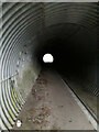
Tunnel under A82
This tunnel leads from the Milburn housing estate west up to Milburn or Carman Muir or north along a footpath parallel to the A82 to the Vale of Leven Cemetery.
Images at Image and Image show the west and east ends. This photo illustrates the length of this unlit pedestrian tunnel.
For those brave enough to wander through at night-time, it is apparently a hang-out for bats.
Image: © Pete Marrison
Taken: 27 Jan 2023
0.08 miles
9
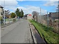
Turnbull Avenue, Burnbrae
The view is from further along the road that is shown in Image At the far right is a railway bridge: Image
Image: © Lairich Rig
Taken: 2 Apr 2017
0.08 miles
10
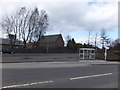
View across the B857 to St Mungo's Scottish Episcopal Church
On the southern outskirts of Alexandria, north of Renton.
Image: © Barbara Carr
Taken: 21 Apr 2013
0.08 miles