IMAGES TAKEN NEAR TO
Peel Street, DUMBARTON, G82 5LD
Introduction
This page details the photographs taken nearby to Peel Street, G82 5LD by members of the Geograph project.
The Geograph project started in 2005 with the aim of publishing, organising and preserving representative images for every square kilometre of Great Britain, Ireland and the Isle of Man.

There are currently over 7.5m images from over14,400 individuals and you can help contribute to the project by visiting https://www.geograph.org.uk
Image Map
Images are licensed for reuse under creativecommons.org/licenses/by-sa/2.0
Notes
- Clicking on the map will re-center to the selected point.
- The higher the marker number, the further away the image location is from the centre of the postcode.
Image Listing (167 Images Found)
Images are licensed for reuse under creativecommons.org/licenses/by-sa/2.0
Image
Details
Distance
1
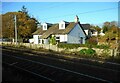
Cottage beside the railway
Tigh-na-Mara, at the end of Peel Street.
Image: © Richard Sutcliffe
Taken: 4 Nov 2022
0.05 miles
2
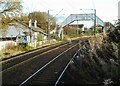
Footbridge over the railway
Seen from Cardross Station.
Image: © Richard Sutcliffe
Taken: 4 Nov 2022
0.06 miles
3
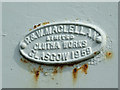
Bridge maker's plate
On the railway footbridge at Peel Street.
P & W Maclellan
limited
Clutha Works
Glasgow 1959
Image: © Thomas Nugent
Taken: 12 Jul 2013
0.06 miles
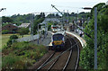
4
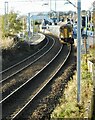
Train running through Cardross station
British Rail Class 156 No. 156 457 passes through Cardross station without stopping, en route for Glasgow Queen Street.
Image: © Richard Sutcliffe
Taken: 4 Nov 2022
0.07 miles
5
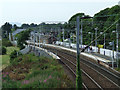
Cardross railway station
Viewed from the footbridge at Peel Street.
Image: © Thomas Nugent
Taken: 12 Jul 2013
0.08 miles
6
Cardross railway station
Viewed from the footbridge at Peel Street.
Image: © Thomas Nugent
Taken: 12 Jul 2013
0.08 miles
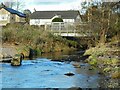
7
Two bridges
The bridge in the background carries the Glasgow to Helensburgh railway line over the Kilmahew Burn. The nearer bridge used to carry a footpath over the burn, but has been replaced by a more recent, wider structure Image
Image: © Richard Sutcliffe
Taken: 4 Nov 2022
0.09 miles
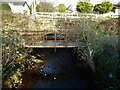
8
Footbridge over the burn
The bridge carries a footpath that runs alongside the railway line over the Kilmahew Burn (or is it the Cardross Burn? See Image for more information).
Image: © Richard Sutcliffe
Taken: 4 Nov 2022
0.09 miles
9
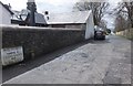
Peel Street, Cardross
Just west of the Coach House Inn, opposite the clubhouse of Cardross Golf Club.
Image: © Barbara Carr
Taken: 18 Apr 2013
0.09 miles
10
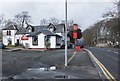
The Coach House Inn, Cardross
Opposite the golf club, on the A814 travelling northwestward to the village centre.
Image: © Barbara Carr
Taken: 18 Apr 2013
0.10 miles