IMAGES TAKEN NEAR TO
Main Road, DUMBARTON, G82 5JX
Introduction
This page details the photographs taken nearby to Main Road, G82 5JX by members of the Geograph project.
The Geograph project started in 2005 with the aim of publishing, organising and preserving representative images for every square kilometre of Great Britain, Ireland and the Isle of Man.

There are currently over 7.5m images from over14,400 individuals and you can help contribute to the project by visiting https://www.geograph.org.uk
Image Map
Images are licensed for reuse under creativecommons.org/licenses/by-sa/2.0
Notes
- Clicking on the map will re-center to the selected point.
- The higher the marker number, the further away the image location is from the centre of the postcode.
Image Listing (121 Images Found)
Images are licensed for reuse under creativecommons.org/licenses/by-sa/2.0
Image
Details
Distance
2
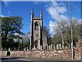
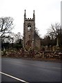
Former Parish Church, Cardross
Only the gothic tower and flanking bays survive of the 1826-7 church. It was bombed in 1941 and the ruin was later preserved as a monument. The graveyard contains some interesting 17th, 18th and 19th century grave monuments. It is Category B listed http://portal.historicenvironment.scot/designation/LB1152.
Image: © Richard Sutcliffe
Taken: 4 Nov 2022
0.02 miles
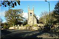
3
Former Parish Church, Cardross
Only the gothic tower and flanking bays survive of the 1826-7 church. It was bombed in 1941 and the ruin was later preserved as a monument. The graveyard contains some interesting 17th, 18th and 19th century grave monuments. It is Category B listed http://portal.historicenvironment.scot/designation/LB1152.
Image: © Richard Sutcliffe
Taken: 4 Nov 2022
0.02 miles
4
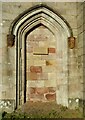
Blocked-up door to tower
The old entrance to the tower of the former parish church, which was bombed in 1941. The moulded doorway features two red sandstone carved mask labelstops. The modern inscribed plaque in the centre reads:
To the glory of God
the tower of this Church was restored
as witness to past faith
and future hope
Summer 1999
"Look forward in Faith"
The building is category B listed http://portal.historicenvironment.scot/designation/LB1152.
Image: © Richard Sutcliffe
Taken: 4 Nov 2022
0.02 miles
5
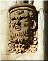
Carved mask labelstop
One of two faces on either side of the doorway to the tower of the former parish church in Cardross Image
Image: © Richard Sutcliffe
Taken: 4 Nov 2022
0.02 miles
6
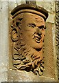
Carved mask labelstop
One of two faces on either side of the doorway to the tower of the former parish church in Cardross Image
Image: © Richard Sutcliffe
Taken: 4 Nov 2022
0.02 miles
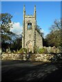
7
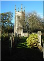
Former Parish Church, Cardross
Only the gothic tower and flanking bays survive of the 1826-7 church. It was bombed in 1941 and the ruin was later preserved as a monument. The graveyard contains some interesting 17th, 18th and 19th century grave monuments. It is Category B listed http://portal.historicenvironment.scot/designation/LB1152.
Image: © Richard Sutcliffe
Taken: 4 Nov 2022
0.02 miles
8
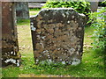
The gravestone of Robert Hunter
The stone is in the churchyard of Image, not far from the entrance beside the main road. As noted in the description of Image, which is located nearby, the burial ground is predominantly rural in character, and the names of local farms appear on many of the stones.
"In memory of Robert Hunter, late farmer in Claddoch, who died 4 July MDCCCXXII aged LXVIII years, and Agnes Menzies his wife, who died 14 May 1828, aged 64 years, also five of their children."
The Farm Horse Tax Rolls of 1797-98 list Robert Hunter as resident at Claddoch; he would then have been in his mid-forties (according to the inscription).
Claddoch (also Cladoch, and Cladoch of Colgrain) long ago ceased to be a farm. However, the ruined farmhouse stood on the shore until recent times, and it has now been converted to a modern dwelling: Image
Image: © Lairich Rig
Taken: 22 Jul 2011
0.02 miles
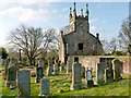
9
The remains of Cardross Old Parish Church
A magnificent ruin but for more details see Lairich Rig's Image]
Image: © James Denham
Taken: 24 Nov 2013
0.02 miles
10
Cardross Old Parish Church
The Canmore page linked from the end-note mentions that the church has been "razed ... to an elevated lawn at sill height". The results can be seen in the present photograph. Compare Image
This is a view from behind the church. The unseen main road through Cardross lies just beyond the far side of the churchyard.
Image: © Lairich Rig
Taken: 18 Jan 2013
0.02 miles