IMAGES TAKEN NEAR TO
Bainfield Road, DUMBARTON, G82 5JQ
Introduction
This page details the photographs taken nearby to Bainfield Road, G82 5JQ by members of the Geograph project.
The Geograph project started in 2005 with the aim of publishing, organising and preserving representative images for every square kilometre of Great Britain, Ireland and the Isle of Man.

There are currently over 7.5m images from over14,400 individuals and you can help contribute to the project by visiting https://www.geograph.org.uk
Image Map (Loading...)


Getting Data...Please wait
Leaflet Map data © OpenStreetMap
Images are licensed for reuse under creativecommons.org/licenses/by-sa/2.0
Notes
- Clicking on the map will re-center to the selected point.
- The higher the marker number, the further away the image location is from the centre of the postcode.
Image Listing (138 Images Found)
Images are licensed for reuse under creativecommons.org/licenses/by-sa/2.0
Image
Details
Distance
1
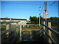
Stop, Look & Listen
A pedestrian level crossing, connecting the Ferry Road to Cardross station footpath to Bainfield Road on the other side.
Image: © Richard Sutcliffe
Taken: 4 Nov 2022
0.07 miles
3
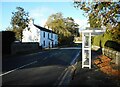
A814, Cardross
Looking north. Bainfield House is on the left.
Image: © Richard Sutcliffe
Taken: 4 Nov 2022
0.08 miles
5
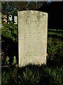
Commonwealth War Grave, Cardross
1472229 GUNNER
W. McMANUS
97TH HEAVY A.A. REGT. R.A.
LONDON SCOTTISH
27TH SEPTEMBER 1941 AGE 19
NEARER MY GOD TO THEE
William McManus, 97 (3rd Battalion, The London Scottish) Heavy Anti-Aircraft, Royal Artillery, was the son of Samuel and Janet McManus, of Cardross.
Image: © Richard Sutcliffe
Taken: 4 Nov 2022
0.09 miles
6
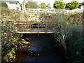
Two bridges
The bridge in the background carries the Glasgow to Helensburgh railway line over the Kilmahew Burn. The nearer bridge used to carry a footpath over the burn, but has been replaced by a more recent, wider structure Image
Image: © Richard Sutcliffe
Taken: 4 Nov 2022
0.09 miles
7
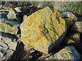
Lichen-covered boulders
Large boulders at the top of the shore, which have been positioned to prevent erosion beside the adjacent railway line. Most are covered by the yellow Xanthoria parietina, known as the maritime sunburst lichen or shore lichen. See Image for a close-up view.
Image: © Richard Sutcliffe
Taken: 4 Nov 2022
0.09 miles
8
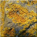
Maritime sunburst lichen
Most of the large boulders at the top of the shore, which have been positioned to prevent erosion beside the adjacent railway line are covered by the yellow Xanthoria parietina, known as the maritime sunburst lichen or shore lichen Image
Image: © Richard Sutcliffe
Taken: 4 Nov 2022
0.09 miles
9

Lichen on rock
On a large boulder at the top of the shore, one of those which have been positioned to prevent erosion beside the adjacent railway line. Probably Lecanora sp.
Image: © Richard Sutcliffe
Taken: 4 Nov 2022
0.09 miles
10
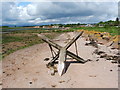
Broken boundary marker
The upper part has become detached from the base, which is shown separately in Image; see that item for further information.
See the end-note for further pictures, including some that show the structure when it was intact. It is clear from those pictures that what is shown in the present photograph is only a part of the top of the marker.
Image: © Lairich Rig
Taken: 13 May 2011
0.09 miles