IMAGES TAKEN NEAR TO
Cardross, DUMBARTON, G82 5HB
Introduction
This page details the photographs taken nearby to G82 5HB by members of the Geograph project.
The Geograph project started in 2005 with the aim of publishing, organising and preserving representative images for every square kilometre of Great Britain, Ireland and the Isle of Man.

There are currently over 7.5m images from over14,400 individuals and you can help contribute to the project by visiting https://www.geograph.org.uk
Image Map
Images are licensed for reuse under creativecommons.org/licenses/by-sa/2.0
Notes
- Clicking on the map will re-center to the selected point.
- The higher the marker number, the further away the image location is from the centre of the postcode.
Image Listing (26 Images Found)
Images are licensed for reuse under creativecommons.org/licenses/by-sa/2.0
Image
Details
Distance
2
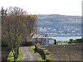
Murrays Road
The narrow road leads to Murrays, which is a long-derelict farm close to the shore of the Clyde. The house on the right is Longbarn.
Image: © Richard Sutcliffe
Taken: 19 Apr 2023
0.05 miles
3
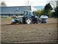
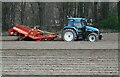
Potato planting
The New Holland 115 tractor has a Reekie Space Setter Potato Planter on the back and presumably is applying fertilizer at the front. Rosebank is behind.
Image: © Richard Sutcliffe
Taken: 19 Apr 2023
0.05 miles
4
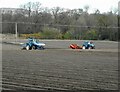
Tractors at work
Two New Holland 115 tractors working on a field at Geilston Farm. The tractor on the right has a Pearson Megastar destoner, used to remove stones from the surface of the field before planting. The other tractor has a Reekie Space Setter Potato Planter on the back and presumably is applying fertilizer at the front.
Image: © Richard Sutcliffe
Taken: 19 Apr 2023
0.05 miles
5
Destoning a field
The New Holland 115 tractor is pulling a Pearson Megastar destoner, used to remove stones from the surface of the field before planting.
Image: © Richard Sutcliffe
Taken: 19 Apr 2023
0.05 miles
6
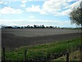
Ploughed field
Just south of the A814, Cardross Road.
Image: © Richard Sutcliffe
Taken: 19 Apr 2023
0.08 miles
7
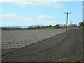
Ploughed field
Just south of the A814, Cardross Road.
Image: © Richard Sutcliffe
Taken: 19 Apr 2023
0.08 miles
8
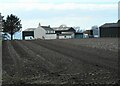
Geilston Farm
Beside a recently ploughed field.
Image: © Richard Sutcliffe
Taken: 19 Apr 2023
0.10 miles
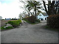
9
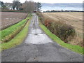
Farm road leading to Gelston Farm
West of Cardross.
Image: © James Denham
Taken: 24 Nov 2013
0.13 miles
10
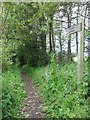
Path to River Clyde shore at Cardross
Image: © Stephen Sweeney
Taken: 12 Jun 2011
0.15 miles