IMAGES TAKEN NEAR TO
Cardross, DUMBARTON, G82 5EW
Introduction
This page details the photographs taken nearby to G82 5EW by members of the Geograph project.
The Geograph project started in 2005 with the aim of publishing, organising and preserving representative images for every square kilometre of Great Britain, Ireland and the Isle of Man.

There are currently over 7.5m images from over14,400 individuals and you can help contribute to the project by visiting https://www.geograph.org.uk
Image Map
Images are licensed for reuse under creativecommons.org/licenses/by-sa/2.0
Notes
- Clicking on the map will re-center to the selected point.
- The higher the marker number, the further away the image location is from the centre of the postcode.
Image Listing (34 Images Found)
Images are licensed for reuse under creativecommons.org/licenses/by-sa/2.0
Image
Details
Distance
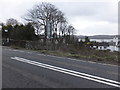
2
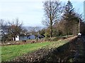
Ardoch from the east
Looking northwesterly along the A814 at the entrance to Ardoch village.
Image: © Barbara Carr
Taken: 18 Apr 2013
0.02 miles
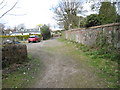
3
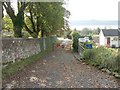
Start of the Ardoch to Levengrove right of way
This lane was photographed from the point where it branches off from Image; this is also the location of the signpost that marks the start of the right of way.
The lane leads a short distance downhill, and then through a railway underpass, emerging at the shore. For another view of the same area, but looking back uphill from the other side of the gate, see: Image
As for the right of way to Levengrove, much of the path, which is located in a grassy fringe above the shore, is often extremely overgrown with bramble stems and similar vegetation; depending on the tide, it may be easier either to walk along the shore itself, or to follow the edges of the fields that lie on the other side of the path.
Image: © Lairich Rig
Taken: 20 Oct 2006
0.07 miles

5
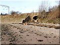
Footpath from Ardoch emerges onto the beach
As described at Image, the footpath passes under a railway underpass (shown here), to emerge onto the beach. From here, the route can, if the tide is out, be followed along the shore; further on, it again becomes a made path: Image
Image: © Lairich Rig
Taken: 21 Nov 2008
0.09 miles
6
Foreshore at Ardoch
Foreshore at Ardoch which is a right of way
Image: © Eddie Mackinnon
Taken: 11 Apr 2007
0.09 miles
7
Right of Way at Ardoch
Right of Way at Ardoch looking from Railway Bridge towards A814 there is no parking allowed in this lane and there is a locked gate if you try and enter from main road
Image: © Eddie Mackinnon
Taken: 11 Apr 2007
0.09 miles
8
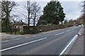
The A814 at the entrance to Ardoch House
The white line on the pavement (extreme right) marks the start of the mile marked in furlongs towards Cardross, see Image
Image: © Barbara Carr
Taken: 18 Apr 2013
0.10 miles
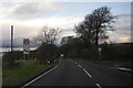
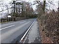
10
The A814 in Ardoch
A public footpath to Levengrove Park (3.6km) leads off to the south of the road.
Image: © Barbara Carr
Taken: 18 Apr 2013
0.11 miles