IMAGES TAKEN NEAR TO
Rowan Drive, DUMBARTON, G82 5EH
Introduction
This page details the photographs taken nearby to Rowan Drive, G82 5EH by members of the Geograph project.
The Geograph project started in 2005 with the aim of publishing, organising and preserving representative images for every square kilometre of Great Britain, Ireland and the Isle of Man.

There are currently over 7.5m images from over14,400 individuals and you can help contribute to the project by visiting https://www.geograph.org.uk
Image Map
Images are licensed for reuse under creativecommons.org/licenses/by-sa/2.0
Notes
- Clicking on the map will re-center to the selected point.
- The higher the marker number, the further away the image location is from the centre of the postcode.
Image Listing (61 Images Found)
Images are licensed for reuse under creativecommons.org/licenses/by-sa/2.0
Image
Details
Distance
1
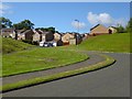
Perrays Drive
On entering Dumbarton from the direction of Cardross, by means of the main road, this is the first area of housing seen to the north of the road.
See http://www.geograph.org.uk/snippet/17333 on the "Perrays" Name, which was associated with Image long before this housing was built.
Image: © Lairich Rig
Taken: 9 Aug 2013
0.05 miles
2
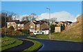
Perrays Drive
The foreground part of the road is in the same grid square as the photographer, but it crosses the grid line about 20 metres before reaching the houses.
The area of housing as a whole is called Lennox Gardens, but the street names are all of a kind — Perrays Drive/Way/Crescent/Court/Grove — referring probably to nearby Image or, with a lesser likelihood, to other Perrays place-names formerly in use; see https://www.geograph.org.uk/snippet/17333 for a detailed discussion of these names.
The small structure to the right of the road, just before the houses, is an electricity sub-station.
Image: © Lairich Rig
Taken: 12 Jan 2020
0.07 miles
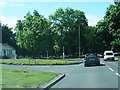
4
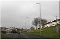
Approaching Dumbarton from the west
Image: © Elliott Simpson
Taken: 30 Apr 2016
0.08 miles
6

Welcome to Dumbarton
Approaching the ancient capital of Strathclyde on the A814.
Image: © Barbara Carr
Taken: 18 Apr 2013
0.08 miles
7
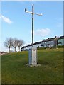
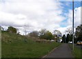
Automated weather station
The location is near a junction of Image (a road) and Cardross Road.
Image: © Lairich Rig
Taken: 18 Jan 2013
0.08 miles
8
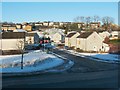
Hawthorn Avenue
Cardross Road runs across the image from left to right in the foreground. The road branching off from it is Hawthorn Avenue.
The elevated viewpoint for this photograph was the top of a slope in front of neighbouring Westcliff.
Image: © Lairich Rig
Taken: 24 Dec 2010
0.09 miles
9
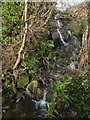
Burn flowing down slope
The view is what would be seen when looking to the left from the point shown in Image As the map shows, at the top of this slope are the backs of houses alongside Cardross Road.
Image: © Lairich Rig
Taken: 10 Feb 2016
0.11 miles
10
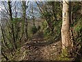
The Shore Circular Path
The picture has been framed similarly to the earlier Image, but with better lighting; as before, the Clyde can be seen indistinctly in the left background. A few of the trees along this part of the path have fairy doors on them.
Image: © Lairich Rig
Taken: 10 Feb 2016
0.11 miles