IMAGES TAKEN NEAR TO
Westcliff, DUMBARTON, G82 5DL
Introduction
This page details the photographs taken nearby to Westcliff, G82 5DL by members of the Geograph project.
The Geograph project started in 2005 with the aim of publishing, organising and preserving representative images for every square kilometre of Great Britain, Ireland and the Isle of Man.

There are currently over 7.5m images from over14,400 individuals and you can help contribute to the project by visiting https://www.geograph.org.uk
Image Map
Images are licensed for reuse under creativecommons.org/licenses/by-sa/2.0
Notes
- Clicking on the map will re-center to the selected point.
- The higher the marker number, the further away the image location is from the centre of the postcode.
Image Listing (79 Images Found)
Images are licensed for reuse under creativecommons.org/licenses/by-sa/2.0
Image
Details
Distance
1
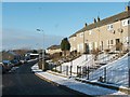
Westcliff
The street is called Westcliff, and the surrounding area is generally known by the same name. For some of the other streets in this area, see Image and Image
Image: © Lairich Rig
Taken: 24 Dec 2010
0.02 miles
2
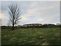
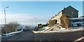
Housing on the edge of Dumbarton
Rather exposed on a hilltop but with good views across the Clyde.
Image: © Jonathan Thacker
Taken: 2 Nov 2017
0.03 miles
3
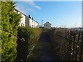
A path at Westcliff
A road called Westcliff (also the name of the area) runs parallel to this path on higher ground behind the houses on the left; at intervals, flights of steps lead down from there to this path. Behind the fence on the right is a steep slope; at the bottom are a railway line, Image, a Image, and the Image, amongst other things.
See Image for the opposite view. The Clyde can be seen in the right background of the present picture.
Image: © Lairich Rig
Taken: 12 Jan 2020
0.04 miles
4
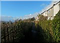
A path at Westcliff
This is the opposite view to Image, which see for further comments. The high ground in the left background is on the other side of the Clyde.
Image: © Lairich Rig
Taken: 12 Jan 2020
0.05 miles
5
Westcliff and Waverley Terrace
Image is the street on the left (and the name of the area). In the foreground, Waverley Terrace leads off to the right.
On the name Waverley Terrace, see the comments for nearby Image
Image: © Lairich Rig
Taken: 24 Dec 2010
0.09 miles
6
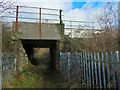
Path leading under railway line
As shown on the map, a path leads along the eastern side of the sewage works, passing the entrance (Image) and then, as shown here, heading underneath a railway line.
The path is a local core path, the Shore Circular Path.
Image: © Lairich Rig
Taken: 10 Feb 2016
0.11 miles
8
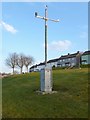
Automated weather station
The location is near a junction of Image (a road) and Cardross Road.
Image: © Lairich Rig
Taken: 18 Jan 2013
0.12 miles
9
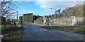
Entrance to sewage works
The works are also shown in Image The present view is from a local core path called the Shore Circular Path. That route crosses the road here.
Image: © Lairich Rig
Taken: 10 Feb 2016
0.12 miles
10
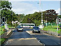
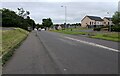
A814 Cardross Road
The A814 passing through the western suburbs of Dumbarton.
Image: © David Dixon
Taken: 26 Sep 2019
0.12 miles