IMAGES TAKEN NEAR TO
Castlehill Quadrant, DUMBARTON, G82 5AH
Introduction
This page details the photographs taken nearby to Castlehill Quadrant, G82 5AH by members of the Geograph project.
The Geograph project started in 2005 with the aim of publishing, organising and preserving representative images for every square kilometre of Great Britain, Ireland and the Isle of Man.

There are currently over 7.5m images from over14,400 individuals and you can help contribute to the project by visiting https://www.geograph.org.uk
Image Map
Images are licensed for reuse under creativecommons.org/licenses/by-sa/2.0
Notes
- Clicking on the map will re-center to the selected point.
- The higher the marker number, the further away the image location is from the centre of the postcode.
Image Listing (67 Images Found)
Images are licensed for reuse under creativecommons.org/licenses/by-sa/2.0
Image
Details
Distance
1
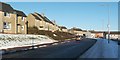
Hawthornhill Road, Castlehill
This is the eastern end of Hawthornhill Road; the junction with Castlehill Road is not far ahead (just beyond the two cars). The houses in the right-hand half of the image are on the latter road.
For a view in the opposite direction along the same part of the road, see Image
For other sections, see Image and Image
Image: © Lairich Rig
Taken: 24 Dec 2010
0.05 miles
2
Hawthornhill Road and Our Lady and St. Patrick's High School
From the east, at the junction with Castlehill Road.
Image: © Stephen Sweeney
Taken: 23 Mar 2011
0.07 miles
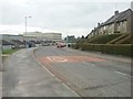
3
Castlehill Road
This part of Dumbarton is called Castlehill. The photograph was taken at the junction with Image
For details of the Castle Hill after which the area is named, see Image
Image: © Lairich Rig
Taken: 24 Dec 2010
0.07 miles
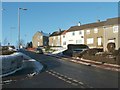
4

Barbers' shop and takeaway
They are shown from the other side of Castlehill Road. Right of centre, against the wall, is a piece of metalwork, shown in detail in Image; it features carved dragons. Although the name of the takeaway also contains the word "Dragon", I am told that the metalwork itself is earlier, and was present when the premises were called "The Keep" (which is the name that is obscured by the bus stop sign).
[Update: By mid-2022, the outside of the building looked very different, and, amongst other changes, the metalwork had been removed.]
Image: © Lairich Rig
Taken: 25 Apr 2020
0.08 miles
5
The Keep
Bar on Castlehill Road. A sign outside the entrance to the Saloon bar reads:
NO HORSES
TO BE LEFT
UNTIED
Next door is the New Dragon Inn - a Chinese and Thai takeaway.
Image: © Richard Sutcliffe
Taken: 1 Sep 2023
0.08 miles
6
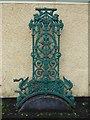
Metalwork, Castlehill Road
[Update: by mid-2022, the outside of the building had been redecorated, and this metalwork had been removed. Among the new decor was a "No Horses to be Left Untied" sign beside the saloon door.]
See Image for context. The setting is the west side of Castlehill Road, in front of a building that had been occupied for several decades by a Chinese takeaway with "Dragon" in its name; note the dragons in the lower half of the picture.
The Latin motto at the top of the ironwork is "Virtute Tutus" ("by virtue secure" or equivalent).
Image: © Lairich Rig
Taken: 5 Jan 2018
0.08 miles
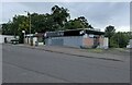
7
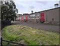
Leven Valley Enterprise Centre
The enterprise centre has various units available for rental. It is a former school annex which was converted to commercial use about 1994.
Image: © Richard Sutcliffe
Taken: 1 Sep 2023
0.09 miles
8
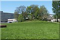
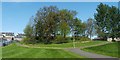
Arthur's Seat
The wooded knoll shown here is located within the Image, and is named Arthur's Seat on large-scale OS maps. For further information, see Image
In the background of the present photograph, on the left, is Image
(also shown in another contributor's earlier picture: Image).
Image: © Lairich Rig
Taken: 30 Apr 2011
0.10 miles
9
Arthur's Seat
The wooded knoll shown here is located within the Image (and appears in that photograph); see that item for further information.
On OS maps from the first edition (c.1860) onwards, the knoll is called Arthur's Seat. Arthur's Seat is similar to the nearby Image, but is smaller. For a view from a different angle, see Image
As noted in the article linked from the end-note, a monument to Robert Bontine Cunninghame Graham (often referred to as "Don Roberto") used to stand on the near side of this knoll; that monument was later moved to Gartmore. See Image for more on that topic.
The monument was unveiled here in a ceremony that took place on the 28th of August, 1937 (it is described in the Lennox Herald, in the issues of the 28th of August and the 4th of September, 1937, from which the following description is drawn). It is about 12 feet high, was designed by Alexander Wright, F.R.I.A.S., is made of local whinstone, and was built by Messrs Jameson and McCallion of Dumbarton.
Its central feature is a bronze portrait bust of Mr Cunninghame Graham, by Alexander Proudfoot, R.S.A.
Above this is a bronze tablet, by the Argentine sculptor Emilio J. Sarniguet, depicting the head of Robert's criollo horse Pampa; Robert kept Pampa for over twenty years, and did not suffer a single fall.
The portrait bust of Robert himself is flanked by two stones, the one on the left sent by Argentine admirers of Robert, and bearing the word "Argentina". On the right is a similar stone from Uruguay.
Below the portrait bust is an inscribed tablet, noting, amongst other things, that Robert died in Argentina, and that he was interred on Inchmahome (Image). The tablet is of Leoch stone, and was carved by Messrs Gray and Co., monumental sculptors, Glasgow.
On one of the top corners of the memorial is the coat of arms of the Cunninghame Graham family, and, on the other, a Scots thistle. An anchor-shaped design on the memorial is the symbol that Robert used as a horse-brand.
Image: © Lairich Rig
Taken: 30 Apr 2011
0.10 miles
10
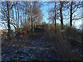
Castle Hill: view up the western side
See Image for the opposite view, down the slope.
Someone pointed out to me in a conversation about half an hour later that there is a causeway-like path down this side (which is what my picture was intended to capture). See the comments at https://www.geograph.org.uk/article/Mains-of-Cardross-and-Castle-Hill#castle-hill for further discussion; in brief, there is no physical evidence that there was ever a building on this knoll, but the presence of what looks like a path on this side had been noted about a century ago.
Image: © Lairich Rig
Taken: 8 Jan 2018
0.10 miles