IMAGES TAKEN NEAR TO
Cordale Avenue, DUMBARTON, G82 4QF
Introduction
This page details the photographs taken nearby to Cordale Avenue, G82 4QF by members of the Geograph project.
The Geograph project started in 2005 with the aim of publishing, organising and preserving representative images for every square kilometre of Great Britain, Ireland and the Isle of Man.

There are currently over 7.5m images from over14,400 individuals and you can help contribute to the project by visiting https://www.geograph.org.uk
Image Map
Images are licensed for reuse under creativecommons.org/licenses/by-sa/2.0
Notes
- Clicking on the map will re-center to the selected point.
- The higher the marker number, the further away the image location is from the centre of the postcode.
Image Listing (123 Images Found)
Images are licensed for reuse under creativecommons.org/licenses/by-sa/2.0
Image
Details
Distance
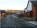
1
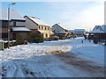
New Cordale Road, Renton
This photograph was taken in the middle of the Cordale area of Renton; for more information, see Image
About halfway up the right-hand side of the photograph, Jackson Place leads off to the right; the last-cited link explains who is commemorated by that street name.
Image: © Lairich Rig
Taken: 29 Nov 2010
0.04 miles
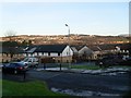
2
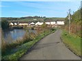
Cycle route at Renton
This is a view over the same part of the route as shown at Image, but looking in the opposite direction. The present photograph was taken from near the Image at Cordale Point.
The houses of the New Cordale estate can be seen ahead, with Image (Image) visible on the hillside in the background.
Image: © Lairich Rig
Taken: 25 Oct 2010
0.06 miles
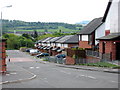
3
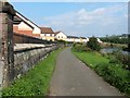
Cycle route at Stirling Street
This is National Cycle Network route 7, as seen from the foot of Stirling Street. The houses visible to the left are part of the New Cordale estate.
For a detail hidden among the vegetation at the foot of the pillar on the left, see Image
The cycle route closely follows the river here, but, not far ahead, it cuts across the neck of Cordale Point (Image) in order to avoid a lengthy diversion (the route does likewise at nearby Dalquhurn Point: Image).
For a view along the same section of the route, but in the opposite direction, see Image
Image: © Lairich Rig
Taken: 21 Sep 2008
0.06 miles
4
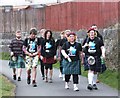
KiltWalkers east of Renton
Walking 'the wrong way' (from Balloch southward to Dumbarton) I did a lot of clapping and cheering as the brave souls nearing the end of their marathon from Hampden passed me on their way to Balloch. See Image for details (and how to get involved next time!).
Image: © Barbara Carr
Taken: 21 Apr 2013
0.06 miles
5
Glen View, Renton
Relatively new build houses in the Vale.
Image: © Stephen Sweeney
Taken: 6 Dec 2008
0.07 miles
6
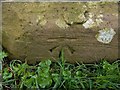
Cut bench mark on wall
The mark is at the base of the pillar that appears on the left in Image, where there is even, conveniently, an arrow pointing down to its location, though the mark itself would have been hidden by vegetation when that picture was taken.
According to OS records, this third-order cut bench mark is 0.3 metres above ground level, and 6.693 metres above Newlyn datum.
For more on bench marks, and for explanations of terminology used above, see the following shared description, written by another contributor.
Image: © Lairich Rig
Taken: 17 Mar 2014
0.08 miles
7
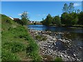
The River Leven
The picture was taken from the foot of some steps: Image The water level was low after a long spell of dry weather. For the view from the top of the grassy bank, see Image
Image: © Lairich Rig
Taken: 24 May 2019
0.08 miles
8
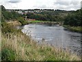
River Leven
Just upstream of Renton. The river forms a big loop here with a narrow neck. Using the cycle path you leave the river and within a few metres rejoin it again after cutting the neck of the loop.
Image: © Richard Webb
Taken: 1 Sep 2009
0.10 miles
10
Stirling Street Renton
Stirling Street Renton looking west towards the River Leven from the main street
Image: © Eddie Mackinnon
Taken: 13 May 2007
0.10 miles