IMAGES TAKEN NEAR TO
Main Street, DUMBARTON, G82 4LX
Introduction
This page details the photographs taken nearby to Main Street, G82 4LX by members of the Geograph project.
The Geograph project started in 2005 with the aim of publishing, organising and preserving representative images for every square kilometre of Great Britain, Ireland and the Isle of Man.

There are currently over 7.5m images from over14,400 individuals and you can help contribute to the project by visiting https://www.geograph.org.uk
Image Map
Images are licensed for reuse under creativecommons.org/licenses/by-sa/2.0
Notes
- Clicking on the map will re-center to the selected point.
- The higher the marker number, the further away the image location is from the centre of the postcode.
Image Listing (215 Images Found)
Images are licensed for reuse under creativecommons.org/licenses/by-sa/2.0
Image
Details
Distance
1
Memorial to the International Brigades
The statue is located outside Image, and was unveiled on the 27th of August, 2011. It commemorates volunteers from Renton who joined the International Brigades to defend the Spanish Republican government against Franco's forces.
Image: © Lairich Rig
Taken: 6 Nov 2011
0.04 miles
2
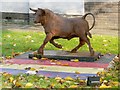
Ma Centre, Renton
The building, which was later(*) renamed the John Connolly Centre, is on Main Street. The statue of a bull, visible at the right, was unveiled in August of 2011: Image
[(*) See the back page of the "Lennox Herald" of 15 Nov 2013.]
When the first-edition OS map was surveyed in 1860, Renton had a Gaelic Free Church. The centre of that church was at about the south-eastern corner of the modern building shown here. For the rear, see Image
Image: © Lairich Rig
Taken: 6 Nov 2011
0.04 miles
3
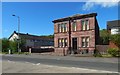
The Victoria Institute
It was built in 1887, and it served as Renton Public Library before becoming Renton Mosque (or West Dunbartonshire Muslim Education Society). See Image for another contributor's earlier picture.
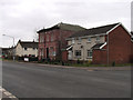
Part of a house can be seen to its right (north); that was the site of Renton Public Hall, later known as the Roxy Cinema; it eventually burned down (in the 1970s, I think).
Image: © Lairich Rig
Taken: 27 Apr 2020
0.05 miles
4
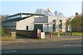
The rear of the leisure centre
The view is through a locked gate at the top of a flight of steps (I was simply curious about where they led): Image The building is one that I always knew as Renton Leisure Centre, a name I continue to use even though the building has had several changes of name since then: see Image, showing the front.
Image: © Lairich Rig
Taken: 13 May 2018
0.05 miles
5
View from Footpath at Renton and A82 SE
Image: © Eddie Mackinnon
Taken: 15 Apr 2006
0.05 miles
6
Victoria Institute Renton
Victoria Institute Renton was a local Library now closed without public consultation by W Dunbartonshire Council
Image: © Eddie Mackinnon
Taken: 10 Apr 2006
0.05 miles
7
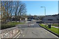
View to McNaught Place
The view is from where Image crosses above the railway line. McNaught Place is ahead; the clubhouse of Renton Bowling Club is on the right. Back Street heads off to the left; the road was then being resurfaced: Image Image is in the left background.
Image: © Lairich Rig
Taken: 10 Apr 2019
0.06 miles
8
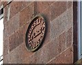
Rossbank Place: date stone
The view is from the footpath / cycle path along the west side of the River Leven. The building itself is set back about 80 metres from Main Street, and access to it is by means of a pend through a building set closer to the street.
When this building was erected there were two churches nearby; another one would be built just a few years later: Image
The existing ones nearby were the Gaelic Free Church at Image, about 40 metres to the northwest of Rossbank Place (see comments at Image), and one that is variously labelled "Mission Church" (1860), "U.P.Church" (1897) and "U.F.Church" (1914), at Image, corresponding to present-day Trinity Place, 60 metres WSW of Rossbank Place.
See the last paragraph at Image for the dates of the two churches that are no longer present; the "Parish Church in Alexander St" mentioned there is Renton Trinity Parish Church itself.
Image: © Lairich Rig
Taken: 20 Dec 2017
0.06 miles
9
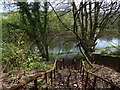
Steps to the River Leven footpath
The footpath at the bottom is also part of cycle route NCN 7. The River Leven itself can be seen directly ahead. Behind the photographer is a locked gate, beyond which is Image
Image: © Lairich Rig
Taken: 13 May 2018
0.07 miles
10
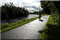
National Cycleway No. 7 and the River Leven
Image: © Mick Garratt
Taken: 26 Aug 2017
0.07 miles