IMAGES TAKEN NEAR TO
Dalquhurn Lane, DUMBARTON, G82 4LR
Introduction
This page details the photographs taken nearby to Dalquhurn Lane, G82 4LR by members of the Geograph project.
The Geograph project started in 2005 with the aim of publishing, organising and preserving representative images for every square kilometre of Great Britain, Ireland and the Isle of Man.

There are currently over 7.5m images from over14,400 individuals and you can help contribute to the project by visiting https://www.geograph.org.uk
Image Map
Images are licensed for reuse under creativecommons.org/licenses/by-sa/2.0
Notes
- Clicking on the map will re-center to the selected point.
- The higher the marker number, the further away the image location is from the centre of the postcode.
Image Listing (193 Images Found)
Images are licensed for reuse under creativecommons.org/licenses/by-sa/2.0
Image
Details
Distance
1
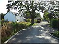
Dalquhurn Lane, Renton
By the River Leven.
Image: © Stephen Sweeney
Taken: 4 Sep 2012
0.02 miles
2
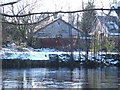
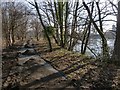
Steps to the river
This photograph shows a set of steps leading down to the River Leven; the picture was taken from a footpath on the opposite bank. A covering of snow has made the steps more clearly visible than usual.
The book "Renton Between the Wars" (2007), by the late Jim Murphy, explains: "Before the village got its own water supply, water was obtained from the river or using the rainwater barrels. Steps were provided at four points on the river embankment to give pedestrian access to either collect water or wash clothes. These are still in existence but are hidden by overgrowth on the river banking."
Image: © Lairich Rig
Taken: 11 Feb 2009
0.02 miles
3
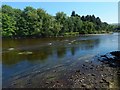
The River Leven above Dalquhurn Point
The green and white patches are a species of Water-crowfoot, an aquatic plant that was conspicuous here because prolonged dry weather had lowered the water level. For the flowers, see Image, taken further upriver in similar conditions, but on a different occasion.
Image: © Lairich Rig
Taken: 27 Jun 2018
0.03 miles
4
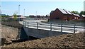
Dalquhurn Estate
This is the northern end of the housing development. When this picture was taken, some homes were occupied, and other areas of the site were still being developed. See also Image
Image can be seen in the distant background, at the extreme left.
For the area on other side of the lade, on the left, see Image
Image: © Lairich Rig
Taken: 30 Apr 2011
0.04 miles
5
Leaf galls on Sycamore
The galls are caused by mites, which I believe(*) to be of the species Aceria cephalonea (syn. Artacris cephaloneus).
The tree itself is between the cycle path and the River Leven, not far from a Image
- - • - -
(*) The identification is according to the keys (specifically, the text) in "British Plant Galls" (2ed; Redfern & Shirley, 2011), and is based in large part on the host, the size of the galls, and the fact that the apex, where there is one, is very blunt and rounded.
The accompanying illustrations to that key give a quite different impression, suggesting that these are the galls of Aceria macrorhyncha (synonyms Aceria macrorhynchus and Artacris macrorhynchus).
Nevertheless, I have found the galls of that species to be typically much more pointed (Image). It may be that the illustrations are, in this case, a little misleading, or perhaps the appearance of the galls changes as they become more mature.
Image: © Lairich Rig
Taken: 24 May 2018
0.04 miles
6
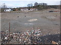
Dalquhurn Point
View across wasteland on the extremity of a new housing estate towards established housing on the banks of the River Leven.
Image: © Barbara Carr
Taken: 21 Apr 2013
0.05 miles
7
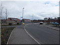
Junction with Dalquhurn Lane
In a new currently off-map housing estate, the road called 'Dalquhurn Lane' leads to the houses at Dalquhurn Point.
Image: © Barbara Carr
Taken: 21 Apr 2013
0.05 miles
8
Path improvements in progress
This part starts beside the foot of Image; the foot of the bridge is shown in Image For the far end of the same route, see Image
Workmen from the local council had been putting in considerable effort to improve the paths that follow the bank of the River Leven around the outer edge of the Vale of Leven Industrial Estate. This picture shows a section that had been prepared for the next step of the process.
See Image for a nearby part of the route, shown before improvement.
Click on the end-note title for other views on this woodland walk.
Image: © Lairich Rig
Taken: 18 Feb 2013
0.05 miles
9
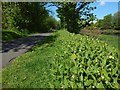
Tuberous Comfrey by the cycle path
See Image for a close-up of part of this patch.
The path is part of cycle route NCN 7. The River Leven can be seen on the right. Not far ahead, but just out of sight from here, is a Image
Image: © Lairich Rig
Taken: 17 May 2018
0.05 miles
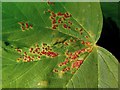
10
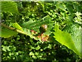
Fig gall on wych elm
The tree on which this gall was growing stands between the River Leven and the adjacent section of cycle route (that section is shown in Image). Many of these galls were present on the tree, and some leaves bore more than one of them, as shown in Image By late July, they had become brown and dried-up in appearance.
These fairly large, stalked galls go by the common name of "fig galls". They are produced by a species of aphid, Tetraneura ulmi.
Image: © Lairich Rig
Taken: 4 Jun 2010
0.05 miles