IMAGES TAKEN NEAR TO
Havoc Road, DUMBARTON, G82 4JW
Introduction
This page details the photographs taken nearby to Havoc Road, G82 4JW by members of the Geograph project.
The Geograph project started in 2005 with the aim of publishing, organising and preserving representative images for every square kilometre of Great Britain, Ireland and the Isle of Man.

There are currently over 7.5m images from over14,400 individuals and you can help contribute to the project by visiting https://www.geograph.org.uk
Image Map
Images are licensed for reuse under creativecommons.org/licenses/by-sa/2.0
Notes
- Clicking on the map will re-center to the selected point.
- The higher the marker number, the further away the image location is from the centre of the postcode.
Image Listing (75 Images Found)
Images are licensed for reuse under creativecommons.org/licenses/by-sa/2.0
Image
Details
Distance
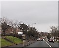
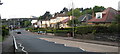
1
Havoc Road
See Image for more information. The present photograph was taken from a point about 100 metres further along the road, at the point where it passes above the Dumbarton-to-Helensburgh railway line.
The turning for Image (a street) is not far ahead, on the right. Further ahead, where a couple of white buildings can be seen on the left, Havoc Road meets the main road (Cardross Road).
Image: © Lairich Rig
Taken: 24 Mar 2011
0.01 miles
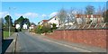
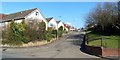
2
Cardross Road
Ahead, on the left, where a car is emerging, is the junction with Havoc Road.
Image: © Lairich Rig
Taken: 24 Dec 2010
0.04 miles
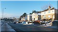
3
Dumbarton, Cardross Road
Approaching the Church of Jesus Christ of Latter-day Saints which is ahead on the left.
Image: © David Dixon
Taken: 26 Sep 2019
0.04 miles
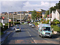
4
Cardross Road Dumbarton
View of Cardross Road Dumbarton from the high school crossing looking towards Wescliff
Image: © Eddie Mackinnon
Taken: 13 May 2007
0.04 miles
5
Westfield
This street is simply called Westfield. The photograph was taken from the junction with Image (the nearest of the houses also appears in that picture).
Image: © Lairich Rig
Taken: 24 Mar 2011
0.05 miles
6
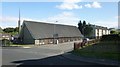
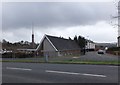
Church of Jesus Christ of Latter-Day Saints
The building is near the junction of Cardross Road (foreground) and Talisman Avenue.
Image: © Lairich Rig
Taken: 9 Aug 2013
0.05 miles
7
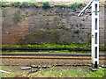
Railway cutting at Dumbarton tunnels
The line is cut through red sandstone on the approach to the tunnels from the west. Viewed from and east bound train.
Image: © Thomas Nugent
Taken: 13 Apr 2016
0.06 miles
8
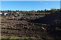
Rubble at Talisman Avenue
A block had been reduced to rubble here, as had another one behind the photographer's position: Image
Image: © Lairich Rig
Taken: 27 Oct 2018
0.06 miles
9
Talisman Avenue
View southward from the A814, on the western outskirts of Dumbarton.
Image: © Barbara Carr
Taken: 18 Apr 2013
0.07 miles