IMAGES TAKEN NEAR TO
Cardross Road, DUMBARTON, G82 4JQ
Introduction
This page details the photographs taken nearby to Cardross Road, G82 4JQ by members of the Geograph project.
The Geograph project started in 2005 with the aim of publishing, organising and preserving representative images for every square kilometre of Great Britain, Ireland and the Isle of Man.

There are currently over 7.5m images from over14,400 individuals and you can help contribute to the project by visiting https://www.geograph.org.uk
Image Map
Images are licensed for reuse under creativecommons.org/licenses/by-sa/2.0
Notes
- Clicking on the map will re-center to the selected point.
- The higher the marker number, the further away the image location is from the centre of the postcode.
Image Listing (79 Images Found)
Images are licensed for reuse under creativecommons.org/licenses/by-sa/2.0
Image
Details
Distance
1
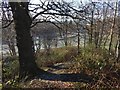
Castle Hill: view down the western side
This is a view from the top of the knoll that gives the Castlehill area of Dumbarton its name. The flat, pale-green area below is the Image, covered in frost.
The rectangular feature that can be seen directly ahead, 100 metres away, in the present picture is a football pitch in an enclosure; in the picture just linked, it can also be seen in front of the left-hand side of the large building in the background (which is Image).
There is a path of sorts down this side of the knoll; see Image
Image: © Lairich Rig
Taken: 8 Jan 2018
0.05 miles
2
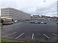
Our Lady and St Patrick's High School
Dumbarton high school, just north of the A814.
Image: © Barbara Carr
Taken: 18 Apr 2013
0.06 miles
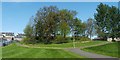
3
Cunninghame Graham Memorial Park
The name of the park commemorates Robert Bontine Cunninghame Graham (1852-1936), an adventurer and politician who was a steadfast advocate of Scottish Home Rule.
At the eastern entrance of the park (shown in Image) is a stone which bears the text "Cunninghame Graham Memorial Park 'the Mony'" (see Image for a view of that stone).
"Mony" here refers to a monument. It does not refer to the small stone just mentioned, but, rather, to a large monument to Cunninghame Graham which used to stand within the park. It was located beside the wooded knoll (Arthur's Seat) that can be seen ahead, to the left of the path, in the present photograph; the monument was unveiled there in 1937, and remained at that spot until 1981, when it was moved to Gartmore (Image).
See Image for a description of the monument.
The large building in the background is Image (earlier picture Image), which is all quiet on this occasion (during the school holidays). OLSP arose from the merger of Notre Dame (a girls' school – see Image) and St Patrick's (a boys' school). By the start of 2018, OLSP had moved to a new site at the top of Bellsmyre: Image
Similar to Arthur's Seat, but larger, is an eminence called Image, which is located in the wooded north-eastern corner of the park; part of that area is visible at the right-hand edge of the photo; see Image for another view. Castle Hill gave the Castlehill area of Dumbarton its name; see also Image
Image: © Lairich Rig
Taken: 24 Dec 2010
0.08 miles
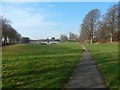
4
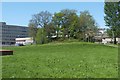
Arthur's Seat
The wooded knoll shown here is located within the Image, and is named Arthur's Seat on large-scale OS maps. For further information, see Image
In the background of the present photograph, on the left, is Image
(also shown in another contributor's earlier picture: Image).
Image: © Lairich Rig
Taken: 30 Apr 2011
0.08 miles
5
Arthur's Seat
The wooded knoll shown here is located within the Image (and appears in that photograph); see that item for further information.
On OS maps from the first edition (c.1860) onwards, the knoll is called Arthur's Seat. Arthur's Seat is similar to the nearby Image, but is smaller. For a view from a different angle, see Image
As noted in the article linked from the end-note, a monument to Robert Bontine Cunninghame Graham (often referred to as "Don Roberto") used to stand on the near side of this knoll; that monument was later moved to Gartmore. See Image for more on that topic.
The monument was unveiled here in a ceremony that took place on the 28th of August, 1937 (it is described in the Lennox Herald, in the issues of the 28th of August and the 4th of September, 1937, from which the following description is drawn). It is about 12 feet high, was designed by Alexander Wright, F.R.I.A.S., is made of local whinstone, and was built by Messrs Jameson and McCallion of Dumbarton.
Its central feature is a bronze portrait bust of Mr Cunninghame Graham, by Alexander Proudfoot, R.S.A.
Above this is a bronze tablet, by the Argentine sculptor Emilio J. Sarniguet, depicting the head of Robert's criollo horse Pampa; Robert kept Pampa for over twenty years, and did not suffer a single fall.
The portrait bust of Robert himself is flanked by two stones, the one on the left sent by Argentine admirers of Robert, and bearing the word "Argentina". On the right is a similar stone from Uruguay.
Below the portrait bust is an inscribed tablet, noting, amongst other things, that Robert died in Argentina, and that he was interred on Inchmahome (Image). The tablet is of Leoch stone, and was carved by Messrs Gray and Co., monumental sculptors, Glasgow.
On one of the top corners of the memorial is the coat of arms of the Cunninghame Graham family, and, on the other, a Scots thistle. An anchor-shaped design on the memorial is the symbol that Robert used as a horse-brand.
Image: © Lairich Rig
Taken: 30 Apr 2011
0.08 miles
6
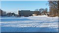
Cunninghame Graham Memorial Park
The view is as in the earlier Image, but without the snow or the recently-demolished Image; see Image
The wooded knoll called Image is at the far right; the smaller knoll that is to its left, a little further away, is Image See the end-note for more on these.
Image: © Lairich Rig
Taken: 27 Feb 2019
0.08 miles
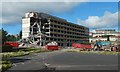
7
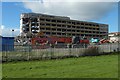
Demolition of the former OLSP
See Image for a view from a different angle. For views of the building before demolition began, see Image, and other pictures linked from there.
Image: © Lairich Rig
Taken: 6 Oct 2018
0.09 miles
8

Our Lady and St Patrick's High School
This OLSP building is shown from a distance in Image and in other contributors' earlier pictures: Image / Image
The present picture was taken after the school had relocated (in October 2017) to Bellsmyre: see Image / Image for the new campus.
The building shown in the present picture was therefore out of use; it seemed a good idea to photograph it again, in case it was cleared away.
Part of a knoll called Image is at the far right.
Image: © Lairich Rig
Taken: 8 Jan 2018
0.09 miles
9
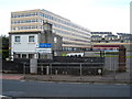
Our Lady and St Patricks High School
Our Lady and St Patricks High School Dumbarton
Image: © Eddie Mackinnon
Taken: 13 May 2007
0.09 miles
10
Demolition of the former OLSP
See Image for a view from a different angle. For views of the building before demolition began, see Image, and other pictures linked from there.
Image: © Lairich Rig
Taken: 6 Oct 2018
0.09 miles