IMAGES TAKEN NEAR TO
Helenslee Court, DUMBARTON, G82 4HT
Introduction
This page details the photographs taken nearby to Helenslee Court, G82 4HT by members of the Geograph project.
The Geograph project started in 2005 with the aim of publishing, organising and preserving representative images for every square kilometre of Great Britain, Ireland and the Isle of Man.

There are currently over 7.5m images from over14,400 individuals and you can help contribute to the project by visiting https://www.geograph.org.uk
Image Map
Images are licensed for reuse under creativecommons.org/licenses/by-sa/2.0
Notes
- Clicking on the map will re-center to the selected point.
- The higher the marker number, the further away the image location is from the centre of the postcode.
Image Listing (120 Images Found)
Images are licensed for reuse under creativecommons.org/licenses/by-sa/2.0
Image
Details
Distance
1
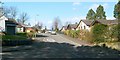
Helenslee Crescent
The photograph was taken from the junction with Image About 40 metres ahead, another junction can be seen, where a fairly short street, Helenslee Court, branches off to the left from Helenslee Crescent.
Image: © Lairich Rig
Taken: 24 Mar 2011
0.02 miles
2
Kirkton Road
This is part of the Kirktonhill area of Dumbarton. The photograph is a view towards the junction with Image
Ahead, on the left, near the junction, a tree can be seen projecting out over the pavement. On closer inspection, it appeared to be a eucalyptus.
Compare Image, a view in the opposite direction from the same point.
Image: © Lairich Rig
Taken: 24 Mar 2011
0.07 miles
3
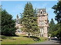
Former stables and technical block
The photograph was taken from Helenslee Road. Some modern buildings provide context for the main subject of interest, which is the older building that lies beyond them.
This was originally a stable block associated with Helenslee House; its listed building report provides further details: http://portal.historic-scotland.gov.uk/designation/LB24897 (at Historic Environment Scotland).
Later, when Helenslee House and its grounds became part of Keil School (see Image), the former stable block was adapted to become the school's technical block (woodwork, metalwork, and technical drawing were taught on the ground floor; there were also, at one time, art and chemistry classrooms on the upper floor). In this period, it was referred to as New House.
The building had become rather run down, and, after some modifications to the building, Mr James G. Gulliver of Campbeltown, the founder of Argyll Foods plc (later to become Safeway plc) conducted its official opening as a new house (Mackinnon House, named after the school's founder) for some of the boarding pupils. This ceremony took place on Thursday the 27th of February, 1986.
Image: © Lairich Rig
Taken: 24 Mar 2011
0.08 miles
4
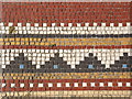
Levenford House (detail): floor tiles
These tiles are located within the porch on the western side of Image
Image: © Lairich Rig
Taken: 9 Sep 2006
0.09 miles
5
Levenford House
For the James Denny who used to live here, see Image
This was not a library (although it is annotated as such on some maps), but it was the headquarters of Dumbarton District Libraries. The council later put the building on the open market, and it was sold off, around 2008, and converted to residential use.
[There were some objections to the sale, one of these being that "West Dunbartonshire Council has a moral obligation to retain Levenford House in public ownership as the property was gifted to the people of Dumbarton in 1939 for use as a library or museum" – quoted from "West Dunbartonshire Council / Report by the Acting Executive Director of Housing, Environment and Economic Development (Housing and Regeneration Services) / Planning Committee: 4 September 2007", Section 3.1.(f).]
The present photograph was taken on one of West Dunbartonshire's Doors Open Days.
The Image is located not far to the SSE.
Image: © Lairich Rig
Taken: 9 Sep 2006
0.09 miles
6
Former lodge of Helenslee House
The building shown here was originally the lodge associated with the mansion house of Helenslee; see its listed building report for further details: http://portal.historic-scotland.gov.uk/designation/LB24898 (at Historic Environment Scotland).
Later, the mansion house and its grounds become part of Keil School: Image The location shown in the present photograph then became the main entrance of the school.
Image: © Lairich Rig
Taken: 24 Mar 2011
0.09 miles
7
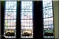
Levenford House (detail): windows
The NNW-facing windows on the ground floor of Image incorporate some stained glass; as mentioned in the Canmore report on this building (see the end-note), these images are based on pictures by John Slezer, as collected in his "Theatrum Scotiae" (of 1693 and 1729).
Even in the present photograph, the familiar double-humped shape of Dumbarton Rock can be recognized in the middle panel; specifically, it is a copy of Slezer's "Their Majesties' Castle of Dumbarton from the West".
The left panel shows Stirling Castle ("The Prospect of her Majesty's Castle of Sterling"), while the one on the right is a view of Edinburgh Castle ("The Southside of the Castle of Edinburgh").
The houses that are indistinctly visible through these windows are at the north-eastern end of Image
Image: © Lairich Rig
Taken: 9 Sep 2006
0.10 miles
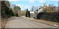
8
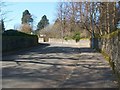
Helenslee Road
This road, in the Kirktonhill area of Dumbarton, leads uphill towards the location of Image
Image: © Lairich Rig
Taken: 24 Mar 2011
0.10 miles
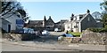
9
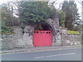
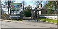
Old gate on West Bridgend
In Dumbarton, west of the River Leven.
Image: © Stephen Sweeney
Taken: 25 Nov 2007
0.10 miles
10
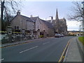
Old house and church in Dumbarton
On West Bridgend.
Image: © Stephen Sweeney
Taken: 25 Nov 2007
0.10 miles