IMAGES TAKEN NEAR TO
Napier Crescent, DUMBARTON, G82 4EE
Introduction
This page details the photographs taken nearby to Napier Crescent, G82 4EE by members of the Geograph project.
The Geograph project started in 2005 with the aim of publishing, organising and preserving representative images for every square kilometre of Great Britain, Ireland and the Isle of Man.

There are currently over 7.5m images from over14,400 individuals and you can help contribute to the project by visiting https://www.geograph.org.uk
Image Map
Images are licensed for reuse under creativecommons.org/licenses/by-sa/2.0
Notes
- Clicking on the map will re-center to the selected point.
- The higher the marker number, the further away the image location is from the centre of the postcode.
Image Listing (50 Images Found)
Images are licensed for reuse under creativecommons.org/licenses/by-sa/2.0
Image
Details
Distance
1
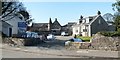
Former stables and technical block
The photograph was taken from Helenslee Road. Some modern buildings provide context for the main subject of interest, which is the older building that lies beyond them.
This was originally a stable block associated with Helenslee House; its listed building report provides further details: http://portal.historic-scotland.gov.uk/designation/LB24897 (at Historic Environment Scotland).
Later, when Helenslee House and its grounds became part of Keil School (see Image), the former stable block was adapted to become the school's technical block (woodwork, metalwork, and technical drawing were taught on the ground floor; there were also, at one time, art and chemistry classrooms on the upper floor). In this period, it was referred to as New House.
The building had become rather run down, and, after some modifications to the building, Mr James G. Gulliver of Campbeltown, the founder of Argyll Foods plc (later to become Safeway plc) conducted its official opening as a new house (Mackinnon House, named after the school's founder) for some of the boarding pupils. This ceremony took place on Thursday the 27th of February, 1986.
Image: © Lairich Rig
Taken: 24 Mar 2011
0.10 miles
2
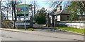
Former lodge of Helenslee House
The building shown here was originally the lodge associated with the mansion house of Helenslee; see its listed building report for further details: http://portal.historic-scotland.gov.uk/designation/LB24898 (at Historic Environment Scotland).
Later, the mansion house and its grounds become part of Keil School: Image The location shown in the present photograph then became the main entrance of the school.
Image: © Lairich Rig
Taken: 24 Mar 2011
0.13 miles
3
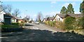
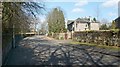
Helenslee Crescent
The photograph was taken from the junction with Image About 40 metres ahead, another junction can be seen, where a fairly short street, Helenslee Court, branches off to the left from Helenslee Crescent.
Image: © Lairich Rig
Taken: 24 Mar 2011
0.13 miles
4
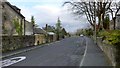
Oxhill Road
The same road is shown, viewed in the opposite direction, in Image; see that link for the origins of the name Oxhill, which applies to this area as well as to the road.
The foreground area of both pictures is the same, though viewed in opposite directions (for example, the same lamp post appears in the foreground of both pictures, and the same figure "20" painted on the road). The present picture was taken from a point opposite the junction with Image
Image: © Lairich Rig
Taken: 1 Feb 2013
0.15 miles
5
Helenslee Road
Behind the wall, to the left of the road, are the former grounds of Keil School; see Image for the main description.
However, a few of the school's properties were located on the other (eastern) side of Helenslee Road; on that side (to the right in this photograph) was Islay Kerr House, which accommodated some of the school's boarding pupils. Islay Kerr was a business associate and long-time friend of the founder of Keil School, William Mackinnon. The building was acquired for the school in 1963, and had formerly been called "Dunstane"; the architect was A.C.Denny (see the tags associated with this photograph).
[According to his obituary, which was published in the Glasgow Herald issue of 10th December 1951, Islay Kerr had been largely responsible for Keil School's move from the original site at Southend (in Kintyre) to Helenslee in Dumbarton, and "it was at his suggestion that the governors bought part of an adjoining field to prevent the encroachment of a projected housing scheme on the policies of the school".]
The boarding houses for pupils at Keil School were: Islay Kerr House, just mentioned; School House (these pupils stayed in the main school building, the mansion house of Helenslee itself, where a mezzanine floor included many dormitories); Mason House (see Image); and New House, latterly called Mackinnon House (see Image). Non-boarding pupils, a minority, made up an additional "day house".
The origins of the names Islay Kerr House and Mackinnon House are clear from the above account. Mason House was named after Mr James Mason, an early headmaster of the school.
Also formerly located on the eastern side of Helenslee Road, but now gone, was another building, which incorporated chemistry and biology classrooms.
Image: © Lairich Rig
Taken: 24 Mar 2011
0.15 miles
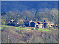
6
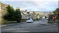
Oxhill Road
This area of Dumbarton is called Oxhill, after the Oxen Hill that is depicted here on the first-edition OS map, which was surveyed in 1860. Oxen Hill was described in the OS Object Name Books (compiled in the 1890s) as "a small arable hill on the farm of Braehead". On the second-edition OS map (c.1898), it was called Ox Hill.
Oxen Hill or Ox Hill was at Image, and Braehead (formerly Easter Hole*) is shown on the maps at Image, just to the south of the main road; those buildings are now known as Braehead Cottages, or as Image
For a view in the opposite direction, see Image In the present view, the junction with Image can be seen on the right, almost opposite the blue car.
[(*) W.C.Maugham, in his "Annals of Garelochside" (1897), on page 263, while aware that Easter Hole was simply another name for Foul Hole, seems to treat that farm as separate from Braehead: "Easter Hole or Foul Hole and Braehead succeed, with Sandybraes, Castlehill, and Muirhouses fronting them" (note "them"). However, other printed reference works treat Braehead as a later name for Easter/Foul Hole; compare, for example, "North Clyde Estuary: An Illustrated Architectural Guide" (F.A.Walker & F.Sinclair, 1992), on the so-called Bruce's Stables, "built for Easter Hole, later Braehead Farm".]
Image: © Lairich Rig
Taken: 1 Feb 2013
0.16 miles
7
Charlotte Street
This street is in the Oxhill area of Dumbarton. The point from which this picture was taken is shown in Image; that item also explains why the area is called Oxhill.
In the present photograph, the distant background is taken up by Image, with the housing estate of Bellsmyre laid out in front of them.
Image: © Lairich Rig
Taken: 1 Feb 2013
0.18 miles
8
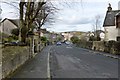
Kirkton Road
This is part of the Kirktonhill area of Dumbarton. The photograph is a view towards the junction with Image
Ahead, on the left, near the junction, a tree can be seen projecting out over the pavement. On closer inspection, it appeared to be a eucalyptus.
Compare Image, a view in the opposite direction from the same point.
Image: © Lairich Rig
Taken: 24 Mar 2011
0.18 miles
9
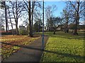
Path near Helenslee House
The view is from beside Helenslee Road. Image can be seen indistinctly on the left, through the trees.
Image: © Lairich Rig
Taken: 4 Dec 2016
0.19 miles
10
Oxhill Place, Dumbarton
Viewed from Newark Castle Park, Port Glasgow.
Image: © Thomas Nugent
Taken: 8 Feb 2016
0.19 miles