IMAGES TAKEN NEAR TO
Levengrove Court, Woodyard Road, DUMBARTON, G82 4DA
Introduction
This page details the photographs taken nearby to Levengrove Court, Woodyard Road, G82 4DA by members of the Geograph project.
The Geograph project started in 2005 with the aim of publishing, organising and preserving representative images for every square kilometre of Great Britain, Ireland and the Isle of Man.

There are currently over 7.5m images from over14,400 individuals and you can help contribute to the project by visiting https://www.geograph.org.uk
Image Map
Images are licensed for reuse under creativecommons.org/licenses/by-sa/2.0
Notes
- Clicking on the map will re-center to the selected point.
- The higher the marker number, the further away the image location is from the centre of the postcode.
Image Listing (325 Images Found)
Images are licensed for reuse under creativecommons.org/licenses/by-sa/2.0
Image
Details
Distance
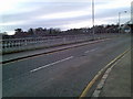
1
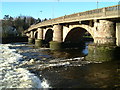
Old Dumbarton Bridge
Old Dumbarton Bridge before it was restored
In the mid 18th century, the Duke of Argyll was anxious to obtain access to Glasgow from his properties in Argyll and at Rosneath. In 1765 John Brown of Dumbarton built the fine Dumbarton Bridge, (Listed 'B') at the site of a ferry crossing. The bridge, with five segmental arches with rounded cutwaters, resulted in the extension of Dumbarton to West Bridgend.
Image: © Eddie Mackinnon
Taken: 28 Dec 1999
0.03 miles
2
River Leven at Old Bridge Dumbarton
View of the River Leven from the Old Bridge Dumbarton the new road bridge can be seen through the arch of the Old Bridge
Image: © Eddie Mackinnon
Taken: 24 May 2007
0.03 miles
3
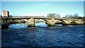
Dumbarton Bridge
The lowest crossing point on the River Leven, built in 1765 by John Brown of Dumbarton. It was widened in 1884 and was reconstructed in 1934. It is Category B listed http://portal.historicenvironment.scot/designation/LB24879.
Image: © Richard Sutcliffe
Taken: 19 Nov 2022
0.03 miles
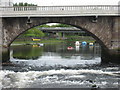
4
Bridges over the River Leven
Looking through the central arch of Dumbarton Bridge Image, which carries Bridge Street over the River Leven. Beyond is the modern road bridge (the Artizan Bridge, built 1973-4), which carries the A814 over the river. Beyond that some of the piers of the Dalreoch Railway Viaduct, dating from 1870 are visible, carrying the Glasgow to Helensburgh and West Highland line.
Image: © Richard Sutcliffe
Taken: 19 Nov 2022
0.03 miles
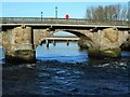
5
Dumbarton Bridge
Seen from Levengrove Park. The lowest crossing point on the River Leven, the bridge was built in 1765 by John Brown of Dumbarton. It was widened in 1884 and was reconstructed in 1934. It is Category B listed http://portal.historicenvironment.scot/designation/LB24879.
Image: © Richard Sutcliffe
Taken: 19 Nov 2022
0.03 miles
6
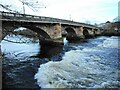
Dumbarton Bridge
The lowest crossing point on the River Leven, built in 1765 by John Brown of Dumbarton. It was widened in 1884 and was reconstructed in 1934. It is Category B listed http://portal.historicenvironment.scot/designation/LB24879.
As the river is tidal, there can be impressive rapids at this point at certain states of the tide.
Image: © Richard Sutcliffe
Taken: 19 Nov 2022
0.03 miles
7
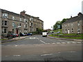
Clydeshore Road Dumbarton
Clydeshore Road Dumbarton from Westbridge end
Image: © Eddie Mackinnon
Taken: 24 May 2007
0.04 miles
8
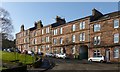
Veir Terrace, Dumbarton
The date stone is hard to make out from here, but it reads "1881". On the name of the street, see the comments at Image
Other pictures: Image / Image / Image
One of the entrances of Levengrove Park can be seen in the left foreground.
Image: © Lairich Rig
Taken: 18 Feb 2013
0.04 miles
9
Bridge Street bridge, Dumbarton
Over the River Leven.
Image: © Stephen Sweeney
Taken: 25 Nov 2007
0.05 miles
10
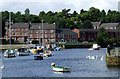
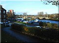
River Leven at Dumbarton
Looking across the river from Riverside lane to Woodyard Place.
Image: © Thomas Nugent
Taken: 21 Aug 2010
0.05 miles