IMAGES TAKEN NEAR TO
School Lane, DUMBARTON, G82 4BP
Introduction
This page details the photographs taken nearby to School Lane, G82 4BP by members of the Geograph project.
The Geograph project started in 2005 with the aim of publishing, organising and preserving representative images for every square kilometre of Great Britain, Ireland and the Isle of Man.

There are currently over 7.5m images from over14,400 individuals and you can help contribute to the project by visiting https://www.geograph.org.uk
Image Map
Images are licensed for reuse under creativecommons.org/licenses/by-sa/2.0
Notes
- Clicking on the map will re-center to the selected point.
- The higher the marker number, the further away the image location is from the centre of the postcode.
Image Listing (154 Images Found)
Images are licensed for reuse under creativecommons.org/licenses/by-sa/2.0
Image
Details
Distance
1
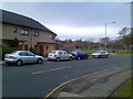
Housing near Dalreoch Station
In west Dumbarton.
Image: © Stephen Sweeney
Taken: 25 Nov 2007
0.03 miles
2
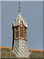
Dumbarton West Kirk: detail
See Image for a view of the whole building, and for more information. The detail shown here is not visible in that view from the front; the present picture was taken from the south, from beside the few remaining memorials from the original burial ground.
Image: © Lairich Rig
Taken: 14 Jan 2013
0.04 miles
3
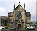
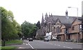
Dumbarton West Kirk
For another contributor's earlier picture, see Image
The first church on this site was built in 1794, when land was feued for the building of a Relief Church and a manse, and for a place of burial. The document granting the feu is dated 6th February 1794, and the construction of the church was completed in that year. The congregation was made up of those who had seceded from the established church in Cardross Parish. They were soon joined by like-minded people from the Burgh of Dumbarton (this area, West Bridgend, was not part of the Burgh of Dumbarton until 1857).
The original 1794 church building no longer exists; it was replaced, twice. The first of those replacement buildings came about after it was decided, in 1859, that a new church should be built; the old building was by then showing signs of deterioration. That second church opened at the end of 1860; the building survives to this day, but it is now used as church halls. In the present photograph, it is the building that is just out of shot to the left, shown separately in Image and Image
The second replacement building is the one shown in the present photograph; the architect was John McLeod (presumably Dumbarton's town architect of that name – Image). The foundation stone was laid in 1886; construction began in that year, and the church opened in 1888. The building is dated 1887 above its entrance: Image The stone used to build it was taken from nearby Image
In the meantime, a separate Dalreoch parish church (1873) had been built not far from here (Image); like the third church (just described) at West Bridgend, Dalreoch Church was designed by John McLeod. In recent times, some Church of Scotland congregations were merged; the West Bridgend and Dalreoch congregations were combined, and they would meet at the church here at West Bridgend, which came to be called the West Kirk. The Dalreoch church building was later demolished.
Of the original graveyard, which was still present in 1969, very few memorials now remain; the original burial site has been cleared away – a pity: Image A mere two memorials remain, located just south of the church hall: the MacAuslan memorial (Image) and the Buchanan memorial (Image).
Aside from those two, there is a war memorial (Image) in the form of a Celtic cross; it was brought here from Dalreoch Church before the latter was demolished. The war memorial for the (pre-merger) West Bridgend congregation itself is made of bronze, and is located within the West Kirk.
Image: © Lairich Rig
Taken: 14 Jan 2013
0.05 miles
4
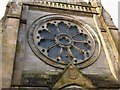
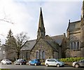
Dumbarton West Kirk: detail
See Image for a view of the whole building, and for more information. The present photograph shows the date 1887 above the main entrance.
Image: © Lairich Rig
Taken: 14 Jan 2013
0.05 miles

7
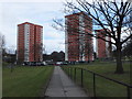
High rise housing, Dennystown
With a view to Dumbarton Rock.
Image: © Barbara Carr
Taken: 18 Apr 2013
0.05 miles
8

Dalreoch station, 1994
View NW, towards Balloch ahead, Craigendoran, Helensburgh and Fort William to left, Dumbarton, Glasgow Queen Street etc. to right: ex-NBR Glasgow - Helensburgh - Fort William (West Highland) line and ex-Dumbarton & Balloch Joint line; North Clyde Electric lines (to Balloch and Helensburgh) since 1960. Ahead is the Vale of Leven. (My Honda Accord is prominent).
Image: © Ben Brooksbank
Taken: 22 Jun 1994
0.05 miles
9
Dumbarton West Kirk: former burial ground
This area behind the church halls of the West Kirk (Image) was, until recent times, a burial ground. In the 1790s, land was feued here for the building of a church (that building is no longer present, but has been replaced twice since then), and for a burial ground.
The building that now serves as church halls (see the link just given) dates from 1860, and was the first of the replacements for the original church. It, in turn, was replaced by the present-day West Kirk, whose rear is visible in the right background of the present photograph. See Image for a view of that building, and for much more information.
When the burial ground was surveyed in 1969, there were still numerous memorials here, but it is obvious from this picture that they have been cleared away since then. Only the MacAuslan Memorial and the Buchanan Memorial remain: Image / Image There is also a War Memorial nearby: Image
Image: © Lairich Rig
Taken: 11 Jan 2013
0.06 miles
10
Dumbarton West Kirk: church halls
This building dates from 1860; the architect was William Spence. As a church, it was superseded by the present-day Image, the building on the right (see that link for much more information). However, the 1860 building is still in use, serving as church halls for the West Kirk. See Image for another view.
Both buildings were successors to the original West Bridgend church, which was built in the 1790s.
Image: © Lairich Rig
Taken: 14 Jan 2013
0.06 miles