IMAGES TAKEN NEAR TO
Clydeshore Road, DUMBARTON, G82 4AF
Introduction
This page details the photographs taken nearby to Clydeshore Road, G82 4AF by members of the Geograph project.
The Geograph project started in 2005 with the aim of publishing, organising and preserving representative images for every square kilometre of Great Britain, Ireland and the Isle of Man.

There are currently over 7.5m images from over14,400 individuals and you can help contribute to the project by visiting https://www.geograph.org.uk
Image Map
Images are licensed for reuse under creativecommons.org/licenses/by-sa/2.0
Notes
- Clicking on the map will re-center to the selected point.
- The higher the marker number, the further away the image location is from the centre of the postcode.
Image Listing (303 Images Found)
Images are licensed for reuse under creativecommons.org/licenses/by-sa/2.0
Image
Details
Distance
1
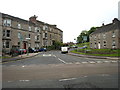
Clydeshore Road Dumbarton
Clydeshore Road Dumbarton from Westbridge end
Image: © Eddie Mackinnon
Taken: 24 May 2007
0.02 miles
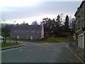
2

Signposts in Dumbarton
Showing the way to Levengrove Park and the proximity of the town to Loch Lomond.
Image: © Stephen Sweeney
Taken: 25 Nov 2007
0.02 miles
3
Old house on Clydeshore Road, Dumbarton
From Bridge Street.
Image: © Stephen Sweeney
Taken: 25 Nov 2007
0.02 miles
4
A development opportunity on Clydeshore Road
Image: © Elliott Simpson
Taken: 30 Apr 2016
0.03 miles
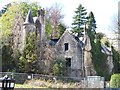
5
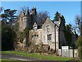
Former gate lodge of Levenford House
Note the fire damage (to the turret in particular), when compared with an earlier view: Image Much of the rest of the damage to the roof is concealed from this angle.
In the shadow to the right of the steps is a (blocked) tunnel to Image, occupying what was once Kirkton Quarry.
Image: © Lairich Rig
Taken: 27 Oct 2017
0.03 miles
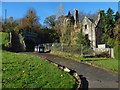
6
Former gate lodge of Levenford House
For context, see Image, where the same building is visible. The lodge is by J.T.Rochead, c.1853. For more details, see its listed building report: http://portal.historic-scotland.gov.uk/designation/LB24918 (at Historic Environment Scotland).
Image itself is located about 130 metres to the NNW of the lodge.
Image: © Lairich Rig
Taken: 24 Mar 2011
0.03 miles
7
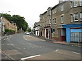
West Bridgend Dumbarton
View of shops at West Bridgend Dumbarton looking north towards Dalreoch
Image: © Eddie Mackinnon
Taken: 24 May 2007
0.04 miles
8
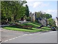
Clydeshore Road and Helenslee Road
With a rather grand house in between the two roads.
Image: © Stephen Sweeney
Taken: 5 May 2008
0.04 miles
9
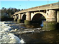
Old Dumbarton Bridge
Old Dumbarton Bridge before it was restored
In the mid 18th century, the Duke of Argyll was anxious to obtain access to Glasgow from his properties in Argyll and at Rosneath. In 1765 John Brown of Dumbarton built the fine Dumbarton Bridge, (Listed 'B') at the site of a ferry crossing. The bridge, with five segmental arches with rounded cutwaters, resulted in the extension of Dumbarton to West Bridgend.
Image: © Eddie Mackinnon
Taken: 28 Dec 1999
0.04 miles
10
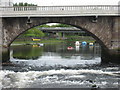
River Leven at Old Bridge Dumbarton
View of the River Leven from the Old Bridge Dumbarton the new road bridge can be seen through the arch of the Old Bridge
Image: © Eddie Mackinnon
Taken: 24 May 2007
0.04 miles