IMAGES TAKEN NEAR TO
Stirling Road, DUMBARTON, G82 3PS
Introduction
This page details the photographs taken nearby to Stirling Road, G82 3PS by members of the Geograph project.
The Geograph project started in 2005 with the aim of publishing, organising and preserving representative images for every square kilometre of Great Britain, Ireland and the Isle of Man.

There are currently over 7.5m images from over14,400 individuals and you can help contribute to the project by visiting https://www.geograph.org.uk
Image Map
Images are licensed for reuse under creativecommons.org/licenses/by-sa/2.0
Notes
- Clicking on the map will re-center to the selected point.
- The higher the marker number, the further away the image location is from the centre of the postcode.
Image Listing (91 Images Found)
Images are licensed for reuse under creativecommons.org/licenses/by-sa/2.0
Image
Details
Distance
1
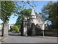
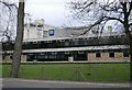
Gateway, West Dunbartonshire Council Offices
Formerly entrance to the Overtoun Estate.
Image: © Roger Cornfoot
Taken: 5 Jun 2015
0.01 miles
2
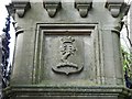
Gatepost detail
For more information about these gateposts, and for a view of the other side, see Image For context, see Image and Image
The present view is of the side that faces away from the main road. It shows the crest of Lord Overtoun: "a dexter arm embowed, the hand grasping a wreath of laurel proper". The gateposts are beside a building that was originally a lodge for Image The avenue described in the end-note began here.
Image: © Lairich Rig
Taken: 3 Feb 2016
0.01 miles
3
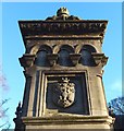
Gatepost detail
The gateposts are shown in context in Image and Image Of the two larger posts, the one on the right bears a plaque on the side facing the main road: Image
The gateposts are category-B listed; according to their listing text, they were built in 1895, and they are the work of the Glasgow architect James Thomson. My further comments below are observations of my own, not taken from the listing text.
The gateposts are at the foot of an avenue leading to Overtoun House; its lower portions (more precisely, the parts below Image) now pass through housing. For the upper half of the avenue, see, for example, Image and Image
Image is part of the same avenue. The bridge was completed, and the entire avenue opened, in 1895, the year in which these gateposts were built: see Image and Image
The present picture shows a detail from one of the larger gateposts (both of them are carved alike). The carving on this side (the south-west side, which faces the main road) is part of the armorial achievement of Lord Overtoun; compare Image, where the same elements – the coronet (small crown), and the details below it – can be seen, executed slightly differently, on the side of the bridge.
The opposite side of both gateposts bears a different carving, a raised arm with the hand holding a laurel wreath: Image This carving is also a detail (specifically, it is the crest) from the arms of Lord Overtoun: in Image, the same crest can be seen appear above the coronet. The coronet itself has six pearls (four visible, two more implied behind), indicating the rank of Baron: in this case, Baron Overtoun of Overtoun.
The building beside these gateposts, shown on the right in Image, was originally a lodge for Overtoun House. I noticed that the Overtoun crest (arm with hand holding a laurel wreath) also appears on Image, which leads me to believe that that building, which is a little over 2 kms from these gateposts, was originally another lodge for Overtoun House; it is not far from the foot of Milton Road, which is today the way by which most vehicles reach Image
Image: © Lairich Rig
Taken: 15 Jan 2016
0.01 miles
4

Dumbarton, Old Overtoun Estate Gateway
Now leading to Strathclyde Police H. Q. and Council Buildings.
Image: © william craig
Taken: 23 Mar 2006
0.01 miles


7
A82 at entrance to Police HQ in Silverton
Image: © John Firth
Taken: 11 May 2012
0.06 miles
8
Dumbarton Police Station
Just off the A82 Loch Lomond road.
Image: © Thomas Nugent
Taken: 18 Mar 2011
0.06 miles
9
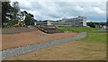
Work on flood defences
The picture shows the construction of flood defences on the Knowle Burn at Garshake. Image are in the background.
See Image and Image for later views.
Image: © Lairich Rig
Taken: 27 Jun 2014
0.06 miles
10
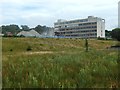
Demolition of the County Buildings
Comparison with a picture taken a month earlier shows that about half of the central building is now gone: Image
Image: © Lairich Rig
Taken: 2 Aug 2019
0.07 miles