IMAGES TAKEN NEAR TO
Garshake Road, DUMBARTON, G82 3LE
Introduction
This page details the photographs taken nearby to Garshake Road, G82 3LE by members of the Geograph project.
The Geograph project started in 2005 with the aim of publishing, organising and preserving representative images for every square kilometre of Great Britain, Ireland and the Isle of Man.

There are currently over 7.5m images from over14,400 individuals and you can help contribute to the project by visiting https://www.geograph.org.uk
Image Map
Images are licensed for reuse under creativecommons.org/licenses/by-sa/2.0
Notes
- Clicking on the map will re-center to the selected point.
- The higher the marker number, the further away the image location is from the centre of the postcode.
Image Listing (151 Images Found)
Images are licensed for reuse under creativecommons.org/licenses/by-sa/2.0
Image
Details
Distance
1
Garshake Road
To the left of the furthest visible part of the road, work was taking place on New Dumbarton Cemetery: Image
Image: © Lairich Rig
Taken: 30 Nov 2014
0.02 miles
2
Garshake Avenue, Bellsmyre
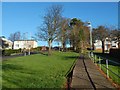
The photograph was taken from Garshake Road, which is visible in the foreground, and which forms the boundary of Bellsmyre on this side.
The street comes to a dead end about 150 metres from this junction, but a Image begins there.
The name Garshake, associated with this area, is fairly old. For example, the Pont/Blaeu map of the Lennox (surveyed 1580s-90s) shows "Garshoak" here, next to "Ouertoun". The area of housing on the other side of Garshake Road, behind the photographer's viewpoint, is called High Overtoun. Image is nearby.
The name Garshake was recorded in the form "Gartschavok" in 1466. It is thought to mean "gart (field or enclosure) of the hawk (Gael. 'seabhog')" [Simon Taylor in "Changing Identities, Ancient Roots"].
- - • - -
On a very different note, I will relate here an incident from around the 1990s: the occupant of one of the houses in this area had workmen in to replace his living-room window (a large, front-facing, downstairs window) and his bathroom window (upstairs). I saw for myself the new living-room window that they had installed: it was a huge pane of frosted glass. I did not get to see the new bathroom window, but (as the owner explained) it was of clear glass.
It would take an astonishing level of stupidity to carry out this work without suspecting that something was amiss; to me, it seems more likely that this was an example of "malicious compliance", the workmen following accidentally-garbled instructions, perhaps in the hope that they could get away with charging extra to set things right.
Image: © Lairich Rig
Taken: 2 Dec 2010
0.03 miles
3
Garshake Terrace, Bellsmyre
Garshake Terrace is the street receding in the left-hand side of the image. In the foreground, Garshake Road leads uphill from the lower-left corner of the photo. (For more on the name Garshake, see Image; that street is the next one up, after Garshake Terrace.)
Visible near the lower-right corner is part of the road of McGregor Drive, in High Overtoun.
Image: © Lairich Rig
Taken: 2 Dec 2010
0.04 miles
4
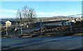
New Dumbarton Cemetery: south-western part
A road (see Image) leading from the main entrance divides the cemetery into a lower or south-western half, shown here, and a higher, north-eastern part. Sections A-G of the cemetery are in this half, and sections H-P in the other.
Image: © Lairich Rig
Taken: 13 Nov 2015
0.07 miles
5
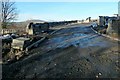
New Dumbarton Cemetery under construction
Click on the end-note title for related pictures.
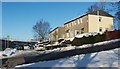
The nearest houses on the left are on Image Carman Hill and adjacent muirs are on the skyline, right of centre. At the far right is what was by then the only remaining one of four high flats at Bellsmyre: Image
In the left foreground of the construction site is what will be the lower of the new cemetery's two entrances: Image
Image: © Lairich Rig
Taken: 30 Nov 2014
0.08 miles
6
New Dumbarton Cemetery under construction
One entrance of the new cemetery is shown here at an early stage of construction; see Image for context. The present picture was likewise taken from outside the site (it is a view through the fence).
Image: © Lairich Rig
Taken: 30 Nov 2014
0.08 miles
7
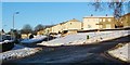
New Dumbarton Cemetery
The picture was taken from outside the site. Construction was still taking place, but the lower entrance and its shelter, shown here, appeared to be almost complete.
Image: © Lairich Rig
Taken: 5 Apr 2015
0.08 miles
8
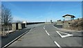
New Dumbarton Cemetery: the lower entrance
The cemetery had been open for almost a year when this wintry picture from Garshake Road was taken, shortly before sunset. It shows the lower of the two entrances to the cemetery.
Image: © Lairich Rig
Taken: 25 Nov 2016
0.08 miles
9
New Dumbarton Cemetery: south-western part
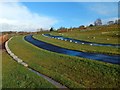
Click on the end-note title for other views.
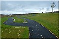
The present picture, taken on Armistice Day (and before this new cemetery had officially opened), shows its lower part. The lairs are divided into sections A-P; the posts that can be seen in this and other views indicate where these sections are located. The lower half of the cemetery, below the memorial wall, contains sections A-G.
Followed in this direction, the paths lead towards the start of a footpath that winds down the hillside from the north-western extremity of the cemetery, and which leads to Garshake Avenue: Image
Image: © Lairich Rig
Taken: 11 Nov 2015
0.08 miles
10
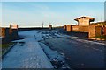
New Dumbarton Cemetery: memorial wall
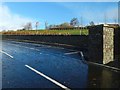
The wall is on the northern side of the road that leads from the cemetery's lower entrance.
Image: © Lairich Rig
Taken: 13 Nov 2015
0.08 miles