IMAGES TAKEN NEAR TO
Stoneyflatt Road, DUMBARTON, G82 3HL
Introduction
This page details the photographs taken nearby to Stoneyflatt Road, G82 3HL by members of the Geograph project.
The Geograph project started in 2005 with the aim of publishing, organising and preserving representative images for every square kilometre of Great Britain, Ireland and the Isle of Man.

There are currently over 7.5m images from over14,400 individuals and you can help contribute to the project by visiting https://www.geograph.org.uk
Image Map
Images are licensed for reuse under creativecommons.org/licenses/by-sa/2.0
Notes
- Clicking on the map will re-center to the selected point.
- The higher the marker number, the further away the image location is from the centre of the postcode.
Image Listing (107 Images Found)
Images are licensed for reuse under creativecommons.org/licenses/by-sa/2.0
Image
Details
Distance
1
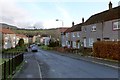
Whiteford Avenue, Bellsmyre
Just ahead, a cul-de-sac branches off to the left; it is also reckoned as part of Whiteford Avenue. It is shown in Image
To the left of the top of the nearest lamp post on the left of the road, it is just possible to pick out a dome as a grey bump on the skyline; it is a Image At the far left in the background is part of Image
Image: © Lairich Rig
Taken: 11 Jan 2013
0.08 miles
2

Dumbarton Cemetery
This is a general view of the newer northern half of the cemetery. For another such view, and for further comments, see Image
This northern half of the cemetery contains a Image
Image: © Lairich Rig
Taken: 14 Jan 2013
0.08 miles
3
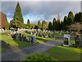
Dumbarton Cemetery
This is a general view of the northern half of the cemetery; for another such view, see Image
This area was not part of the cemetery as it was originally laid out; it was a later extension. This newer northern section has a very different feel about it; the large and varied monuments that are so prevalent in the older part of the cemetery are fascinating and often attractive, but they were of their time. Style and taste have changed, and such structures would be very much out of place here.
Image: © Lairich Rig
Taken: 14 Jan 2013
0.10 miles
4
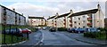
Whiteford Avenue, Bellsmyre
This cul-de-sac branches off from the main body of Image It is not given a separate name.
Image: © Lairich Rig
Taken: 11 Jan 2013
0.10 miles
5
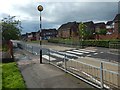
Zebra crossing on Whiteford Avenue
Before the adjacent Aitkenbar Primary School (to the photographer's left) was demolished, this crossing had a dancing lollipop man: Image Most people found that entertaining, but a few complained.
Image: © Lairich Rig
Taken: 14 Sep 2018
0.11 miles
6
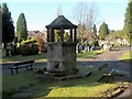
Memorial Fountain
The fountain stands in the northern half of Image The inscription on the near side is extremely worn in places, but the sense of the text makes it possible to fill in the gaps (compare the inscription at Image).
"Erected by the London-Dumbartonshire Association
President – Sir Iain Colquhoun, Bart, KT, DSO, LLD,
Lord Lieutenant of Dumbartonshire
to the honoured memory
of those of the county
who lost their lives
by enemy action
1939-1945"
The far side of the fountain (shown in Image) bears the very worn remnants of a crest and a Latin motto: Image
[Although it is not recorded on the inscription, the memorial was unveiled in September of 1949. Sir Iain Colquhoun had been Lord-Lieutenant of the county from 1919 until his death in November 1948, but was succeeded in that role by Major General Alexander Telfer-Smollett, who performed the unveiling of the memorial.]
Image: © Lairich Rig
Taken: 15 Feb 2011
0.11 miles
7
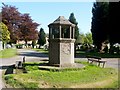
Memorial fountain
This is the same fountain as shown in Image, but viewed from the other side; see that item for further details.
For a closer look at the detail on this side, see Image
Image: © Lairich Rig
Taken: 1 May 2011
0.11 miles
8
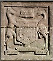
Memorial fountain (detail)
This photograph is a close-up view of the fountain that is shown in Image; these details are indistinct unless, as in this case, the angle of the sun's illumination is favourable.
The motto appears to read "Fide Fortuna Fortes". The elephant with the "castle" (or tower) on its back features in the Dumbarton arms, which "were registered in the Lyon Office in or about AD 1672. This was the year in which was passed the important Act which confers on the Lyon King of Arms the right to grant arms to 'virtuous and well-deserving persons'"; specifically, the Dumbarton arms are described as follows: "Azure, an elephant passant argent, tusked or, bearing on his back a tower proper".
(See Image for another representation.)
Their origin is obscure. They are said to "appear upon the burgh seal appended to the document relating to the ransom of David II, son of Robert the Bruce, at the end of his eleven years of captivity dating from the battle of Neville's Cross", that document being dated 1357.
[The above details about the Dumbarton arms are from "The Dumbarton coat-of-arms" (1909), by Archibald Macdonald.]
Image: © Lairich Rig
Taken: 1 May 2011
0.11 miles
9
Former site of Aitkenbar Primary School
The view is from the junction of Whiteford Avenue (foreground) and Whiteford Crescent (receding on the right).
Compare Image (with the same zebra crossing visible), and Image (from just beyond that crossing), which were taken, respectively, a year earlier and eight months earlier.
Image: © Lairich Rig
Taken: 25 Nov 2020
0.12 miles
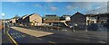
10
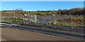
Former site of Aitkenbar Primary School
The crossing at the left is shown from the other side of the road in Image
Housing will be built here. See Image for an earlier picture showing rubble on site, Image for the building that formerly stood here, and Image for its replacement.
Image: © Lairich Rig
Taken: 14 Nov 2019
0.13 miles