IMAGES TAKEN NEAR TO
St. Andrews Crescent, DUMBARTON, G82 3ER
Introduction
This page details the photographs taken nearby to St. Andrews Crescent, G82 3ER by members of the Geograph project.
The Geograph project started in 2005 with the aim of publishing, organising and preserving representative images for every square kilometre of Great Britain, Ireland and the Isle of Man.

There are currently over 7.5m images from over14,400 individuals and you can help contribute to the project by visiting https://www.geograph.org.uk
Image Map
Images are licensed for reuse under creativecommons.org/licenses/by-sa/2.0
Notes
- Clicking on the map will re-center to the selected point.
- The higher the marker number, the further away the image location is from the centre of the postcode.
Image Listing (103 Images Found)
Images are licensed for reuse under creativecommons.org/licenses/by-sa/2.0
Image
Details
Distance
1
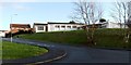
St Andrew's Church, Bellsmyre
The church is located on Image, near the junction with St Andrew's Crescent.
Image: © Lairich Rig
Taken: 9 Jan 2012
0.06 miles
2

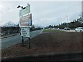
Barloan Toll Roundabout
The picture was taken from a path that leads up into Bellsmyre. As the name suggests, Barloan Toll was located on the boundary of the burgh.
When trams were running in Dumbarton (from 1907 to 1928), there was a branch line to Barloan Toll (now the site of the roundabout). The branch line left the main line at Church Place (beside Image) and followed Image, Strathleven Place, and Image [see "Dumbarton's Trams and Buses", A.W.Brotchie and R.L.Grieves, 1985].
Compare Image
Image: © Lairich Rig
Taken: 9 Jan 2012
0.10 miles
3
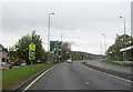
Approaching Barloan Toll roundabout
A82 heading west
Image: © John Firth
Taken: 11 May 2012
0.10 miles
4
Aitkenbar Circle, Bellsmyre
In the distance, the upper part of a couple of the high flats in Bellsmyre can be seen, just left of centre; for those, see Image
The street name preserves the name of a farm that was located near this spot, and which was recorded on the first-edition OS map (c.1860) as Aitkenbarr, and on some later maps as "Aitken Barr". In Roy's Military Survey of Scotland (1740s-50s), the same location is simply called "Barr".
Further ahead, on the far side of Image, a continuation of this road is called Image
Image: © Lairich Rig
Taken: 9 Jan 2012
0.10 miles
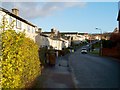
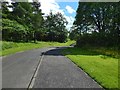
5
Mansewood Drive
A quiet residential area of Dumbarton.
Image: © Matt McFadzean
Taken: 27 Dec 2015
0.10 miles
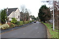
6
A82 to Crianlarich
Exit road to Crianlarich from the roundabout north of the centre of Dumbarton.
Image: © Barbara Carr
Taken: 21 Apr 2013
0.11 miles
7
Path between underpasses
The subject is as in Image, but the view is in the opposite direction. In the present picture, the path heads right, into an underpass below the A82. From there, it emerges at Barloan Place.
Image: © Lairich Rig
Taken: 4 Jun 2017
0.11 miles
8
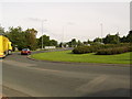
Barloan Roundabout
Gateway to Bellsmyre, Alexandria, Loch Lomond and Dumbarton town centre.
Image: © Stephen Sweeney
Taken: 23 Aug 2007
0.11 miles
9

Dumbarton Cemetery
This is a general view of the newer northern half of the cemetery. For another such view, and for further comments, see Image
This northern half of the cemetery contains a Image
Image: © Lairich Rig
Taken: 14 Jan 2013
0.13 miles
10
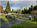
Dumbarton Cemetery
This is a general view of the northern half of the cemetery; for another such view, see Image
This area was not part of the cemetery as it was originally laid out; it was a later extension. This newer northern section has a very different feel about it; the large and varied monuments that are so prevalent in the older part of the cemetery are fascinating and often attractive, but they were of their time. Style and taste have changed, and such structures would be very much out of place here.
Image: © Lairich Rig
Taken: 14 Jan 2013
0.13 miles