IMAGES TAKEN NEAR TO
Bellsmyre Avenue, DUMBARTON, G82 3AY
Introduction
This page details the photographs taken nearby to Bellsmyre Avenue, G82 3AY by members of the Geograph project.
The Geograph project started in 2005 with the aim of publishing, organising and preserving representative images for every square kilometre of Great Britain, Ireland and the Isle of Man.

There are currently over 7.5m images from over14,400 individuals and you can help contribute to the project by visiting https://www.geograph.org.uk
Image Map
Images are licensed for reuse under creativecommons.org/licenses/by-sa/2.0
Notes
- Clicking on the map will re-center to the selected point.
- The higher the marker number, the further away the image location is from the centre of the postcode.
Image Listing (41 Images Found)
Images are licensed for reuse under creativecommons.org/licenses/by-sa/2.0
Image
Details
Distance
1
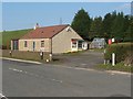
Bellsmyre Cottage
A detached cottage beside Stirling Road; see Image for context. See also Image
There was a cottage called Bellsmyre here at the time of the first-edition OS map (c.1860). The OS Object Name Book describes it as "a cottage on the east side of the Trust Road that leads from Dumbarton to Bonhill". The name Bellsmyre was later given to the large area of housing that appeared to the east and south-east of the cottage after the Second World War.
In Dumbarton Cemetery, near the Image, there is a gravestone, dating from the 1870s or 1880s, for the resident of "Bellismyre Cottage, Dumbarton".
That form of the name is intermediate between the present-day Bellsmyre, and the much older Belliesmyre, which can be seen on certain old estate plans and in some Valuation Rolls. This older spelling does not appear on any OS maps.
The name goes back several centuries. For example, a Teinds Valuation compiled by the parish minister in 1656 includes it among several other local place-names: the relevant entry is for "Guisholme with Belliesmyre" (for "Guisholme", see Image).
[The Teinds Valuation referred to above is "The rentall of the stocked teinds of the Parishine of Dumbartane givin up be Mr David Elphingstoune, minister thereof", as given on page 281, in Appendix F, of "Dumbarton Common Good Accounts 1614-60". David Elphinstone, who compiled the Teinds Valuation given in that appendix, was parish minister at Dumbarton for about 30 years, from 1633 onwards.]
Image: © Lairich Rig
Taken: 18 Mar 2009
0.12 miles
2

Stirling Road at Bellsmyre Cottage
Image is ahead. Bellsmyre is also the name of an area of housing nearby. See the link just given for earlier forms of the place-name.
The Image can be seen, left of centre, in front of Carman Hill.
Image: © Lairich Rig
Taken: 29 Jun 2018
0.13 miles
3
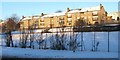
Valeview Terrace, Bellsmyre
The photograph was taken from Stirling Road, and shows the south-western edge of Bellsmyre.
Image: © Lairich Rig
Taken: 2 Dec 2010
0.14 miles
4

Merkins Avenue, Bellsmyre
The appearance of the buildings on this street has changed greatly in recent years. They looked very different about 30 years ago, when I passed through here more often.
Image: © Lairich Rig
Taken: 17 Jul 2017
0.15 miles
5
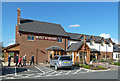
The Malt & Myre
This Brewers Fayre establishment lies at a convenient location for Loch Lomond road traffic.
Image: © Mary and Angus Hogg
Taken: 30 Apr 2013
0.16 miles
6
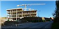
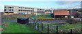
Construction on new OLSP site
The site is shown from another angle, a week earlier, in Image
Image: © Lairich Rig
Taken: 6 Nov 2016
0.18 miles
7
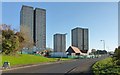
Bellsmyre High Flats
Click on the end-note title for other views.
In the present view, preparations for demolition are under way. The low building in front of the tower block on the right is the Cutty Sark Community Centre; it stands on the same site as the previous community centre, which had been called Howatshaws Hall, and which can be seen in an earlier view Image
See also Image, corresponding to the present picture, but taken almost a year later.
Image: © Lairich Rig
Taken: 23 Nov 2013
0.18 miles
8
Construction on new OLSP site
Comparison with a picture taken about two months earlier shows the progress on the outer shell: Image See also Image, taken about two months after the present picture.
Image: © Lairich Rig
Taken: 27 Dec 2016
0.19 miles
9
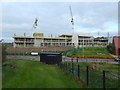
Construction on new OLSP site
At the far right, on the other side of the road, is part of the Cutty Sark Community Centre. In the right foreground is the boundary fence of a mountain bike skills trail (shown in an earlier picture, Image).
For a view from another angle, a week later, see Image
Image: © Lairich Rig
Taken: 30 Oct 2016
0.19 miles
10
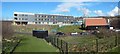
Construction of new OLSP
Compare Image, a similar view from a little over two months earlier.
Image: © Lairich Rig
Taken: 5 Mar 2017
0.19 miles