IMAGES TAKEN NEAR TO
Lomond Drive, DUMBARTON, G82 3AS
Introduction
This page details the photographs taken nearby to Lomond Drive, G82 3AS by members of the Geograph project.
The Geograph project started in 2005 with the aim of publishing, organising and preserving representative images for every square kilometre of Great Britain, Ireland and the Isle of Man.

There are currently over 7.5m images from over14,400 individuals and you can help contribute to the project by visiting https://www.geograph.org.uk
Image Map
Images are licensed for reuse under creativecommons.org/licenses/by-sa/2.0
Notes
- Clicking on the map will re-center to the selected point.
- The higher the marker number, the further away the image location is from the centre of the postcode.
Image Listing (28 Images Found)
Images are licensed for reuse under creativecommons.org/licenses/by-sa/2.0
Image
Details
Distance
1

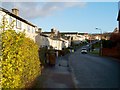
Entrance to Bellsmyre from Stirling Road
Stirling Road runs from left to right along the bottom of the image. The road leading uphill and then veering to the left is Bellsmyre Avenue. Just where it curves out of sight, Valeview Terrace branches off from it, to the left. The road leading off to the right (with a red car in it) is St Andrew's Brae.
Image: © Lairich Rig
Taken: 22 Oct 2008
0.05 miles
2
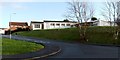
Aitkenbar Circle, Bellsmyre
In the distance, the upper part of a couple of the high flats in Bellsmyre can be seen, just left of centre; for those, see Image
The street name preserves the name of a farm that was located near this spot, and which was recorded on the first-edition OS map (c.1860) as Aitkenbarr, and on some later maps as "Aitken Barr". In Roy's Military Survey of Scotland (1740s-50s), the same location is simply called "Barr".
Further ahead, on the far side of Image, a continuation of this road is called Image
Image: © Lairich Rig
Taken: 9 Jan 2012
0.07 miles
3
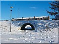
Underpass at the foot of Bellsmyre
The underpass leads below Stirling Road.
The buildings in the background are at St Andrew's Brae, and appear at the right-hand side of Image
Image: © Lairich Rig
Taken: 2 Dec 2010
0.08 miles
4

Dumbarton, River Leven and River Clyde from the air
Looking over the Bellsmyre tower blocks to Bonhill Road, Dumbarton Rock and the rivers Clyde and Leven. Langbank is visible on the south bank of the Clyde. Viewed from a Glasgow bound flight from Newark, USA.
Image: © Thomas Nugent
Taken: 15 Jul 2011
0.09 miles
5
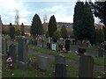
Dumbarton Cemetery
Dumbarton Cemetery with the Kilpatrick Hills beyond.
Image: © Andrew McEwan
Taken: 27 Nov 2005
0.09 miles
6
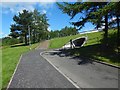
Path between underpasses
The steps directly ahead lead up to the pavement beside Stirling Road. The underpass beside those steps (shown in Image) leads under that road, emerging beside St Andrew's Brae, at the foot of Bellsmyre.
For a view from further back, for more context, see Image
Followed in the opposite direction (Image), the path leads to and through a similar underpass (below the A82) to emerge at Barloan Place.
Image: © Lairich Rig
Taken: 7 Jun 2017
0.10 miles
7
St Andrew's Church, Bellsmyre
The church is located on Image, near the junction with St Andrew's Crescent.
Image: © Lairich Rig
Taken: 9 Jan 2012
0.10 miles
8
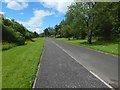
Path between underpasses
For a view from near the far end of the path, and for more information, see Image Particularly at that end, an area to the left (south-west) of the path has been left unmown; the unmown area also extends a little further to north-west, alongside Stirling Road.
That area provides a useful habitat for plants; I observed several Common Spotted-orchids growing there.
For a view in the opposite direction from about the same place, see Image
Image: © Lairich Rig
Taken: 4 Jun 2017
0.11 miles
9
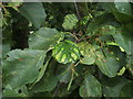
Leaf galls on common alder
The central leaf, with discoloured bulges, is affected by a mite, probably Acalitus brevitarsus. The lower surface (not shown here) is covered with what seems to be a creamy-coloured powdery mass, but is really a dense mass of hairs (called an erineum) whose growth is induced by the mites.
Image: © Lairich Rig
Taken: 12 Sep 2008
0.13 miles
10
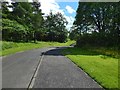
Path between underpasses
The subject is as in Image, but the view is in the opposite direction. In the present picture, the path heads right, into an underpass below the A82. From there, it emerges at Barloan Place.
Image: © Lairich Rig
Taken: 4 Jun 2017
0.14 miles