IMAGES TAKEN NEAR TO
Milton Court, DUMBARTON, G82 2UD
Introduction
This page details the photographs taken nearby to Milton Court, G82 2UD by members of the Geograph project.
The Geograph project started in 2005 with the aim of publishing, organising and preserving representative images for every square kilometre of Great Britain, Ireland and the Isle of Man.

There are currently over 7.5m images from over14,400 individuals and you can help contribute to the project by visiting https://www.geograph.org.uk
Image Map
Images are licensed for reuse under creativecommons.org/licenses/by-sa/2.0
Notes
- Clicking on the map will re-center to the selected point.
- The higher the marker number, the further away the image location is from the centre of the postcode.
Image Listing (59 Images Found)
Images are licensed for reuse under creativecommons.org/licenses/by-sa/2.0
Image
Details
Distance
1
Milton Crescent, Milton
From Milton Brae.
Image: © Stephen Sweeney
Taken: 23 Aug 2007
0.03 miles
2
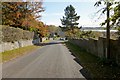
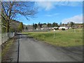
Milton Brae
Milton Brae is the name of the road. This is a view downhill; the River Clyde can be seen in the background.
For a view uphill from about 200 metres further down the road, see Image, which also mentions a few features that can be seen alongside the road.
Image: © Lairich Rig
Taken: 26 Oct 2012
0.04 miles
3
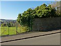
Former site of drinking fountain
The road is shown in Image In the background of that picture, there is a green fence to the left of the road. The area shown here is at the far end of that fence.
OS maps from c.1970 show a drinking fountain here (marked "D Fn"). It is now gone, but its former site is the semicircular area at the foot of the wall. The year of construction, 1937, can still be read on it; for a closer look, see Image
The carved stonework at the entrance of Image, only a short distance down the road, is probably from the same period: Image and Image
Image: © Lairich Rig
Taken: 26 Oct 2012
0.06 miles
4
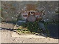
Remains of a drinking fountain
The ruined drinking fountain shown here is at the foot of a wall on the western side of Image
For a view in context, and for further details, see Image The drinking fountain was built in 1937; the year is inscribed on the uppermost stone of the arch.
Image: © Lairich Rig
Taken: 26 Oct 2012
0.06 miles
5
Beside the Milton Burn
Image is to the photographer's left, flowing just behind and parallel to the fence. Much of the area ahead is now laid out as playing fields: Image
Of the buildings visible ahead, the one furthest to the left occupies what was, in 1860, the site of a corn mill.
At the same time, the Milton Printworks were behind (to the north of) that house, the scatter of buildings extending about 220 metres N—S. Bleaching and calico printing was established in Milton at the end of the eighteenth century; the work was mechanised in the mid-nineteenth century. In the second half of that century, paper manufacturing was carried on here.
In 1860, the ruins of a cotton mill on the course of the Milton Burn were visible at about Image, beside the northern end of the printworks.
Image: © Lairich Rig
Taken: 23 Mar 2018
0.06 miles
6
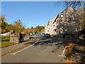
Milton Brae
This road is called Milton Brae; the one branching off to the right is Milton Hill. On the left, there are brick pillars at an entrance of Image There is some carved stonework on those pillars, dating from about 1937: Image / Image
A little further up the road, at the top of the green fence to the left of the road, the remains of a drinking fountain, dating from 1937, can be seen: Image and Image
See Image for a view downhill from about 200 metres further up the road.
Image: © Lairich Rig
Taken: 26 Oct 2012
0.07 miles
7
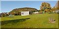
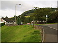
King George's Field, Milton
The picture was taken from Image See also Image and Image
For a view of another part of this area, see Image In the present view, Dumbuck Hill is in the background (Image).
Image: © Lairich Rig
Taken: 26 Oct 2012
0.08 miles
8
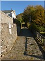
Road to the Old School House
This road leads off from Image; one of the notices here says "Private Road / No Thoroughfare".
Image: © Lairich Rig
Taken: 26 Oct 2012
0.08 miles
9
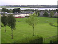
Milton Park and Playing Fields
Firth of Clyde in the background
Image: © Chris Upson
Taken: 28 Sep 2005
0.09 miles
10
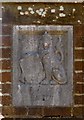
Carved stonework, King George's Field
As shown in Image, there are some brick pillars at an entrance to Image The present picture shows the stonework on the one on the right, which bears the text "KING GEORGE'S FIELD".
For the corresponding detail on the left pillar, see Image
For reasons explained in the end-note, the stones on both pillars have twins in many other King George's Fields. See, for example, Image in Port Glasgow, a perfect match for the stone shown in the present photograph.
Image: © Lairich Rig
Taken: 26 Oct 2012
0.10 miles