IMAGES TAKEN NEAR TO
Whyte Corner, Dumbarton Road, DUMBARTON, G82 2TR
Introduction
This page details the photographs taken nearby to Whyte Corner, Dumbarton Road, G82 2TR by members of the Geograph project.
The Geograph project started in 2005 with the aim of publishing, organising and preserving representative images for every square kilometre of Great Britain, Ireland and the Isle of Man.

There are currently over 7.5m images from over14,400 individuals and you can help contribute to the project by visiting https://www.geograph.org.uk
Image Map (Loading...)


Getting Data...Please wait
Leaflet Map data © OpenStreetMap
Images are licensed for reuse under creativecommons.org/licenses/by-sa/2.0
Notes
- Clicking on the map will re-center to the selected point.
- The higher the marker number, the further away the image location is from the centre of the postcode.
Image Listing (77 Images Found)
Images are licensed for reuse under creativecommons.org/licenses/by-sa/2.0
Image
Details
Distance
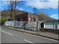
1
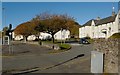
Whyte's Corner, Milton
The houses were built in the 1930s. See Image for a view from a different angle, and for further information.
Image: © Lairich Rig
Taken: 26 Oct 2012
0.01 miles
2
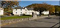
Whyte's Corner, Milton
This area of housing in Milton is called Whyte's Corner, and it was built in the 1930s (the name Whyte's Corner is given on street signs, but elsewhere it is often referred to as Whyte Corner).
The raised portion of the wall has a faded inscription, from 1937, that records a commendation by the Saltire Society, and gives the name of the architect, J Weekes: Image
See Image for a view of the same area from the other end.
I have not come across any explanation of the name Whyte's Corner, but it perhaps refers to the Whytes who lived at Image; nearby Milton Brae led towards that house. For a long time, Barnhill was a seat of the Colquhoun family. However, see Image for evidence that Barnhill was occupied by a Miss Whyte in the 1930s, when these houses were built. See also Image
Image: © Lairich Rig
Taken: 26 Oct 2012
0.01 miles
3
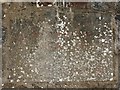
Inscription at Whyte's Corner
For context, see Image and Image The inscription is on the raised part of the wall that can be seen in front of the houses, and it reads as follows.
"The design of these houses
is commended by
the Saltire Society
May 1937
Architect J Weekes FRIBA"
Image: © Lairich Rig
Taken: 26 Oct 2012
0.02 miles
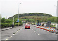
4
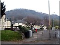
Looking east from Milton, Dumbarton
Towards the hills, part of the Kipatrick Range.
Image: © James Denham
Taken: 24 Nov 2013
0.03 miles
5
Miltonbrae Substation
Image looms in the background, and the road is called Milton Brae. The business based next to the substation sells BBQ huts, log cabins, and the like.
Image: © Lairich Rig
Taken: 23 Mar 2018
0.04 miles
6
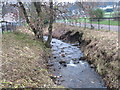
Burn at Milton, Dumbarton
Running down from the Bowie Loch.
Image: © James Denham
Taken: 24 Nov 2013
0.04 miles
7
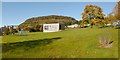
King George's Field, Milton
The picture was taken from Image See also Image and Image
For a view of another part of this area, see Image In the present view, Dumbuck Hill is in the background (Image).
Image: © Lairich Rig
Taken: 26 Oct 2012
0.04 miles
9
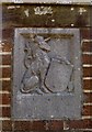
Carved stonework, King George's Field
As shown in Image, there are some brick pillars at an entrance to Image The present picture shows the stonework on the one on the left, which bears the following text: "GEORGE V / AD 1910-1936".
For the corresponding detail on the right pillar, see Image
For reasons explained in the end-note, the stones on both pillars have twins in many other King George's Fields. See, for example, Image in Port Glasgow, a perfect match for the stone shown in the present photograph.
Image: © Lairich Rig
Taken: 26 Oct 2012
0.05 miles
10
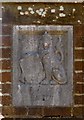
Carved stonework, King George's Field
As shown in Image, there are some brick pillars at an entrance to Image The present picture shows the stonework on the one on the right, which bears the text "KING GEORGE'S FIELD".
For the corresponding detail on the left pillar, see Image
For reasons explained in the end-note, the stones on both pillars have twins in many other King George's Fields. See, for example, Image in Port Glasgow, a perfect match for the stone shown in the present photograph.
Image: © Lairich Rig
Taken: 26 Oct 2012
0.05 miles