IMAGES TAKEN NEAR TO
Lime Road, DUMBARTON, G82 2RP
Introduction
This page details the photographs taken nearby to Lime Road, G82 2RP by members of the Geograph project.
The Geograph project started in 2005 with the aim of publishing, organising and preserving representative images for every square kilometre of Great Britain, Ireland and the Isle of Man.

There are currently over 7.5m images from over14,400 individuals and you can help contribute to the project by visiting https://www.geograph.org.uk
Image Map
Images are licensed for reuse under creativecommons.org/licenses/by-sa/2.0
Notes
- Clicking on the map will re-center to the selected point.
- The higher the marker number, the further away the image location is from the centre of the postcode.
Image Listing (188 Images Found)
Images are licensed for reuse under creativecommons.org/licenses/by-sa/2.0
Image
Details
Distance
1
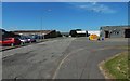
Lime Road
Image: © Lairich Rig
Taken: 1 Jul 2018
0.02 miles
2
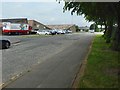
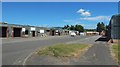
Lime Road
The roads in Broadmeadow Industrial Estate are named after trees. The trees on the right are lime trees: see Image, on one of them.
Image: © Lairich Rig
Taken: 1 Jun 2018
0.03 miles
3
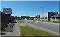
Poplar Road
The view is from the northern end of Image Ahead, on the left, is the beginning of a short Image, with Image just to its right.
There is a T-junction there: Image heads right, and the much shorter Alder Road heads left.
Image: © Lairich Rig
Taken: 1 Jul 2018
0.04 miles
4

Leaf galls on Lime
The galls are on one of the lime trees shown on the right in a view of the appropriately-named Image These distinctive galls are caused by the gall mite species Eriophyes exilis (syn. Aceria exilis).
Image: © Lairich Rig
Taken: 1 Jun 2018
0.05 miles
5
Poplar Road, Dumbarton
This part of the road lies within Broadmeadow Industrial Estate (on which, see Image). All of the roads within the industrial estate are named after trees.
The escarpment of Image is in the background, on the left.
Image: © Lairich Rig
Taken: 15 Dec 2011
0.05 miles
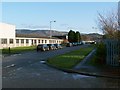
6
Ash Road
The view is from the junction with Image
Image: © Lairich Rig
Taken: 1 Jul 2018
0.06 miles
7
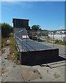
Poplar Road SPS
This sewage pumping station is in a fenced enclosure at the western end of Image; in that picture, it is left of centre, with a dark-red banner on the fence. Just to the left of it is a Image
In the present picture, the industrial yard behind and to the right of the pumping station is the one shown in Image
Image: © Lairich Rig
Taken: 1 Jul 2018
0.07 miles
8
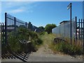
Path to the River Leven
The sign on the right reads "Path / River Leven / 100 yards". The structure behind the fence on the right is Image
The path is the "CP 157" mentioned in the first of the end-notes. It is at the western end of Image; in that picture, it is at the far end of the pavement on the left.
See Image for the other end of this short path, where it meets a longer path along the eastern bank of the River Leven.
Image: © Lairich Rig
Taken: 1 Jul 2018
0.09 miles
9
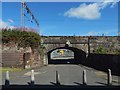
Heading under the railway line
Station Road is on this side, Bankend Road on the other.
Image: © Lairich Rig
Taken: 8 Aug 2020
0.09 miles
10
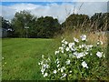
Musk Mallow
(Malva moschata)
The flowers are beside a short path that leads out of Broadmeadow Industrial Estate to meet a much longer footpath along the eastern bank of the River Leven. The short path is the "CP 157" referred to in the end-note, and the present picture shows its western end, at the River Leven. See Image for the other end of it.
As for the flowers of this species, it seems that they are more commonly pink than white: see, for example, Image at Dumbarton Rock. Some cultivated varieties (of which this may be one) have white flowers.
Image: © Lairich Rig
Taken: 6 Sep 2017
0.09 miles