IMAGES TAKEN NEAR TO
Poplar Road, DUMBARTON, G82 2RD
Introduction
This page details the photographs taken nearby to Poplar Road, G82 2RD by members of the Geograph project.
The Geograph project started in 2005 with the aim of publishing, organising and preserving representative images for every square kilometre of Great Britain, Ireland and the Isle of Man.

There are currently over 7.5m images from over14,400 individuals and you can help contribute to the project by visiting https://www.geograph.org.uk
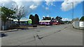
Image Map
Images are licensed for reuse under creativecommons.org/licenses/by-sa/2.0
Notes
- Clicking on the map will re-center to the selected point.
- The higher the marker number, the further away the image location is from the centre of the postcode.
Image Listing (195 Images Found)
Images are licensed for reuse under creativecommons.org/licenses/by-sa/2.0
Image
Details
Distance
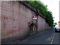
1

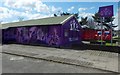
Mural detail
This is just part of the artwork on the building; the building itself is just to the east of one that is used by Tullochan, and which also bears artwork: Image / Image
I was able to confirm, by asking someone who was working outside at the time, that the same artist painted this mural.
The building is on Image; see that picture for context.
Image: © Lairich Rig
Taken: 27 Apr 2018
0.02 miles
2
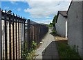
Path in the industrial estate
It ends not far ahead where it meets Image If the path is followed in the opposite direction, it soon makes a sharp right-turn; see Image for the view from just around that corner.
Image: © Lairich Rig
Taken: 3 Jun 2020
0.02 miles
3

Tullochan building detail
The building is beside Image See Image for the mural on the side. The artwork on this building and on an adjacent one (Image) is new.
Image: © Lairich Rig
Taken: 21 Apr 2018
0.04 miles
4
Artwork on the Tullochan building
The mural is new; see Image for a view from a different angle.
The building is on Image; see that picture for context. For the other mural visible there, see Image
Image: © Lairich Rig
Taken: 21 Apr 2018
0.04 miles
5
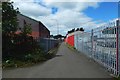
Path in the industrial estate
The path makes a sharp right-turn here to head west; heading back along the other leg of the path from that corner, the view is as in Image
Image: © Lairich Rig
Taken: 3 Jun 2020
0.04 miles
6
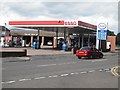
Garage, Townend Road
On the day of a 2p a litre tax rise.
Image: © Richard Webb
Taken: 1 Sep 2009
0.04 miles
7
Poplar Road, Dumbarton
The view is from the junction with Overburn Avenue, and it provides context for pictures of murals that can be seen across the road: Image / Image
Image: © Lairich Rig
Taken: 13 May 2018
0.05 miles
8

Brock Bowling Club
When this picture was taken, the new club house and green shown here appeared to be almost complete (construction began in the latter half of 2011), but the club had not yet relocated from its previous site (Image, beside Dumbarton Academy on Image).
Image: © Lairich Rig
Taken: 1 Jan 2012
0.05 miles
9
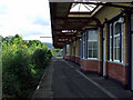
Dumbarton Central station
A disused platform and trackbed, sharing an island with the present Platform 1.
Image: © Thomas Nugent
Taken: 21 Aug 2010
0.06 miles
10
Dumbarton Central station
The north entrance to the station, on Bankend Road.
Image: © Thomas Nugent
Taken: 21 Aug 2010
0.06 miles