IMAGES TAKEN NEAR TO
Geils Avenue, DUMBARTON, G82 2QG
Introduction
This page details the photographs taken nearby to Geils Avenue, G82 2QG by members of the Geograph project.
The Geograph project started in 2005 with the aim of publishing, organising and preserving representative images for every square kilometre of Great Britain, Ireland and the Isle of Man.

There are currently over 7.5m images from over14,400 individuals and you can help contribute to the project by visiting https://www.geograph.org.uk
Image Map (Loading...)


Getting Data...Please wait
Leaflet Map data © OpenStreetMap
Images are licensed for reuse under creativecommons.org/licenses/by-sa/2.0
Notes
- Clicking on the map will re-center to the selected point.
- The higher the marker number, the further away the image location is from the centre of the postcode.
Image Listing (50 Images Found)
Images are licensed for reuse under creativecommons.org/licenses/by-sa/2.0
Image
Details
Distance
1
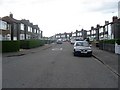
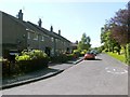
Geils Avenue
Residential street near the Dumbuck warehouses.
Image: © Richard Webb
Taken: 1 Sep 2009
0.04 miles
2
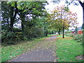
Leaves on the line
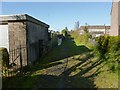
In the 1960s the former Caledonian Railway route between Glasgow and Dumbarton was closed to passengers and the roughly parallel former North British Railway route was electrified. At Dumbuck, east of Dumbarton, British Railways put in a new connection between the two routes and it was the North British line that was closed and the Caledonian route through Dumbarton East station that was electrified. Most of this section of the North British route was eventually converted into a footpath and cycleway and is seen here behind Geils Avenue, about a mile east of Dumbarton.
Image: © A-M-Jervis
Taken: 13 Oct 2007
0.04 miles
4
Path near Second Avenue
The picture was taken from Image; the path leads to Second Avenue, and lies between Image and High Mains Avenue.
Geils was the name of a prominent family in the area (more details can be found near the end of the item Image); the other street name is a reference to High Mains of Colquhoun, on which see Image
Image: © Lairich Rig
Taken: 26 Oct 2012
0.06 miles
5
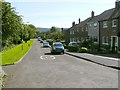
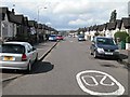
Third Avenue, Dumbarton
The picture was taken from the junction with Image
A cycle route (NCN7; see Image for a nearby part of that route) follows Third Avenue, but leaves the road at the lower-left corner of the image (compare Image, a view along the cycle path towards this corner of the road).
It continues from that point as a footpath and cycle route, in a wooded area between the busy A82 and some bonded warehouses: Image
Image: © Lairich Rig
Taken: 10 Jun 2011
0.10 miles
6
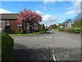
Fourth Avenue, Dumbarton
This is a view from a little further ahead than in Image It shows the junction with Second Avenue.
Image: © Lairich Rig
Taken: 21 Apr 2017
0.10 miles
7
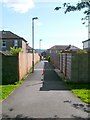
Lane leading to Dumbuck Crescent
The photograph was taken from the cycle route (NCN Route 7), specifically, the part shown in Image
The photograph really shows two short lanes, seen end-to-end; the nearer leads to Dumbuck Crescent. From the far side of that road, another such lane leads to Glasgow Road; the building that lies directly ahead, in the distance, is on the far side of Glasgow Road.
Image: © Lairich Rig
Taken: 10 Jun 2011
0.10 miles
8
Fourth Avenue, Dumbarton
The photograph was taken from the junction with Image For a view from a little further ahead, at the junction with Second Avenue, see Image
Image: © Lairich Rig
Taken: 10 Jun 2011
0.11 miles
9
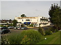
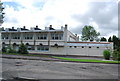
Abbotsford Hotel, Dumbarton
Just off the A82.
Image: © Stephen Sweeney
Taken: 23 Aug 2007
0.12 miles