IMAGES TAKEN NEAR TO
Glenpath, DUMBARTON, G82 2PQ
Introduction
This page details the photographs taken nearby to Glenpath, G82 2PQ by members of the Geograph project.
The Geograph project started in 2005 with the aim of publishing, organising and preserving representative images for every square kilometre of Great Britain, Ireland and the Isle of Man.

There are currently over 7.5m images from over14,400 individuals and you can help contribute to the project by visiting https://www.geograph.org.uk
Image Map
Images are licensed for reuse under creativecommons.org/licenses/by-sa/2.0
Notes
- Clicking on the map will re-center to the selected point.
- The higher the marker number, the further away the image location is from the centre of the postcode.
Image Listing (57 Images Found)
Images are licensed for reuse under creativecommons.org/licenses/by-sa/2.0
Image
Details
Distance
1
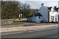
Strowan's Well Road
This photograph shows the junction of the main road (Image) and Strowan's Well Road, in the Barnhill area of Dumbarton. See the link just cited for further context; note that the same building and junction can be seen in that picture.
The well after which Strowan's Well Road is named lies about 200 metres to the ENE of the junction, beyond the far end of the road: Image
Facing Strowan's Well Road, on the other side of Stirling Road, is the junction with Image
Image: © Lairich Rig
Taken: 24 Feb 2011
0.05 miles
2
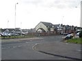
Looking across the A82 in Dumbarton
Image: © Stephen Sweeney
Taken: 31 May 2008
0.06 miles
4
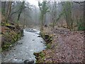
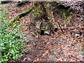
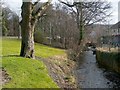
Gruggies Burn
For more information about the burn, see Image
The section shown in the present photograph flows through the Barnhill area; the picture was taken at a location just beyond the north-eastern end of Image
Just below the centre of the image, a dark rock juts out from the right-hand bank of the burn. From near that point, a dark line leads from the burn towards the right-hand edge of the photo. That feature is the channel of a small stream, which flows from Image into Gruggies Burn.
Image: © Lairich Rig
Taken: 11 Feb 2011
0.07 miles
5
Strowan's Well
The well itself appears at the centre of the photograph. The small stream that issues from it flows into Image; see that photograph for context.
The well is shown on the first-edition OS map, which was surveyed in 1860 (it is not named there, but the name Strowan's Well appears on later maps). On the first-edition OS map, there is a building almost facing it across the burn; on later maps, it is called Strowan's Well Cottage.
This well was once the subject of a legal dispute; the following is from records of the Court of Session: "This was an appeal in a petition presented in the sheriff-court of Dumbartonshire by Mr. Geils of Dumbuck against William Thompson and others, inhabitants of Dumbarton, to interdict them from trespassing on the lands of Dumbuck. From time immemorial the public had been in the habit of drawing water from a stream which ran through the lands of Dumbuck; and in 1866 certain of the inhabitants of Dumbarton erected a well, called Strowan's Well, a short distance up the stream from the highway. Mr. Geils did not interfere at the time, but some time after he resolved to carry the water to the highway. The pipes he laid down for the purpose were cut, and in the spring of 1869 he cut off the supply to the well at a point considerably above the well. On 2d July 1869 certain of the inhabitants of Dumbarton went to the point at which the supply was cut off, and removed the obstruction. Mr. Geils presented to the Sheriff a petition for interdict. The respondents averred that the footpath to the well and the well had been public from time immemorial."
For Mr Geils of Dumbuck, see Image The details of what was carried out at the well in 1866 are provided by a similar account of the same events: "some years ago a basin was formed for the well by public subscription, near to the public road, but upon Mr Geil's lands, and without opposition upon his part. But he afterwards resolved to remove this basin to the highway."
(The words quoted from the records of the Court of Session might be taken as meaning that the well was given its name in 1866; however, it is far more likely that Strowan's Well, which was furnished with its basin in that year, had already borne that name for many years.)
The well is also mentioned, in passing, in one of the occasional "Streetwise" features that appear in the Lennox Herald newspaper. In the edition of Friday the 30th of January, 2009, the subject of the feature is "St Rhonan's Lane"; after discussing which particular Rhonan/Ronan this street-name refers to, the article comments that "in addition to the Well of St Ronan at Kilmaronock, others are named after him, which brings us to Strowan's Well at the quarry near Crosslet in Dumbarton, from which Strowan's Road and Image take their names" (for Crosslet, see Image).
Image: © Lairich Rig
Taken: 11 Feb 2011
0.08 miles
6
Overtoun House Circular Path
Barnhill Road, visible on the left in this picture, used to follow a different course: Image That part of its former course is now no more than a rough track, but it forms part of a much longer route called Overtoun House Circular Path.
The rough track leads downhill before passing between the two halves of a disused quarry (as shown in Image); the present photograph shows where the circular path (which leads directly away from the photographer's position, in the right-hand side of the picture) joins present-day Barnhill Road. It follows the line of Barnhill Road down to the busy main road (the A82), crosses that road, and then continues along Greenhead Road.
The River Clyde and the area on its far side can be seen in the background.
Image: © Lairich Rig
Taken: 9 Jan 2012
0.09 miles
7
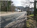
Stirling Road
Just a few metres ahead, the road crosses above Image, which, at the right-hand edge of the photo, runs between the nearest tree and the fence that is visible behind it.
On the left-hand side of the road, the junction with Image is on the near side of the closest building.
Much of the skyline is taken up by Dumbuck Hill, a large part of which has been quarried out: Image
Image: © Lairich Rig
Taken: 24 Feb 2011
0.09 miles
9
Gruggies Burn
For more information about the burn itself, see Image
The present photograph is a view towards the point where the burn passes under the main road (Stirling Road); the arch of the bridge there is visible ahead.
In the left-hand side of the photo, the course of the road is indicated by the stone wall, which is at the far side of the road. Visible on the right are the back gardens of houses in Strowan's Road; for the origin of the name of that road, see Image
For a view in the opposite direction from the same point, see Image
Image: © Lairich Rig
Taken: 24 Feb 2011
0.10 miles
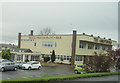
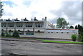
10
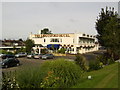
Abbotsford Hotel, Dumbarton
Just off the A82.
Image: © Stephen Sweeney
Taken: 23 Aug 2007
0.10 miles