IMAGES TAKEN NEAR TO
Crosslet Road, DUMBARTON, G82 2LT
Introduction
This page details the photographs taken nearby to Crosslet Road, G82 2LT by members of the Geograph project.
The Geograph project started in 2005 with the aim of publishing, organising and preserving representative images for every square kilometre of Great Britain, Ireland and the Isle of Man.

There are currently over 7.5m images from over14,400 individuals and you can help contribute to the project by visiting https://www.geograph.org.uk
Image Map
Images are licensed for reuse under creativecommons.org/licenses/by-sa/2.0
Notes
- Clicking on the map will re-center to the selected point.
- The higher the marker number, the further away the image location is from the centre of the postcode.
Image Listing (82 Images Found)
Images are licensed for reuse under creativecommons.org/licenses/by-sa/2.0
Image
Details
Distance
1
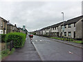
Millburn Road, Dumbarton
Looking east. Junction with Boghead Avenue on the left.
Image: © Richard Dorrell
Taken: 11 Aug 2021
0.07 miles
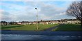
2
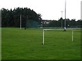
East End Park
Diminutive goalposts and an all weather pitch in a park near Dumbarton East railway station.
Image: © Richard Webb
Taken: 1 Sep 2009
0.07 miles
3
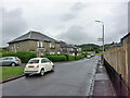
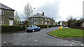
Crosslet Road, Dumbarton
Housing towards the eastern end of the road.
Image: © Richard Dorrell
Taken: 11 Aug 2021
0.08 miles
4
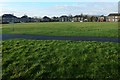
Former site of a mill dam in Silverton
This large grassy space is in Silverton, which is in turn part of Dumbarton East. The path shown in the foreground divides it unequally; the smaller section, behind the photographer, includes a play area. Much of what is now this expanse of grass was once a mill dam; see Image for further information, and for a view of this area in context.
Image: © Lairich Rig
Taken: 24 Dec 2019
0.10 miles
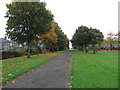
5
Former site of a mill dam in Silverton
The view is from the northeastern end of Lennox Road. The large grassy space ahead is divided unequally by the footpath shown here (see Image for a view from there, looking to the left or northwest). The smaller part, on the right, contains a play area.
Much of that whole grassy expanse was once the site of a mill dam. The body of water is shown but not named on the first-edition map (surveyed 1860—61), bisected by the Parliamentary Boundary: https://maps.nls.uk/view/74941048
The 1896—97 map revision — https://maps.nls.uk/view/82875684 — labels it a "dam", and shows a sluice at its northwestern end, as does the 1914 map revision — https://maps.nls.uk/view/82874268 — which labels it "Mill Dam". The 1937 map revision — https://maps.nls.uk/view/82874271 — shows the former site of the dam with the same outline, but containing marshy ground rather than water. By that time, the housing that is presently (2020) to the south and west of this area was in place.
Note, on the 1914 map revision, the "Crosslet Path" that approached the dam from the west. The 1937 revision shows part of that path running along what had been the southwestern perimeter of the dam, although the section of path approaching from the west had by then been realigned on account of the building of houses.
As should be clear from, in particular, the 1937 map, the mill dam did not occupy all of the area now covered in grass. It occupied about half of that space. Only one lobe of the dam extended out of what is now grass, reaching roughly to what is now a house about 60 metres NNE of the centre of the play area. In relation to the present photograph, that is the house just to the right of the far end of the footpath, seen with a black bin directly in front of it.
The mill served by the mill dam was, I can only guess, the one labelled "Dumbarton Mill (grain)" on the first-edition map. On the way, it passed a "rope and sailcloth factory", with a conspicuously long "rope walk". In terms of modern structures, the old mill was located at Strathleven Place, somewhere around Image At present, the most noticeable feature there is a short path between buildings, much used by people going between the main road (Strathleven Place / Bonhill Road) and St James Retail Park; it is shown in Image Part of the burn itself remains open, and can be seen running SSW from the location just mentioned: Image
Image: © Lairich Rig
Taken: 24 Dec 2019
0.10 miles
6
A Dumbarton cycletrack
In the 19th and early 20th century Britain's private railway companies competed vigorously but could also co-operate with one another. Hence the Caledonian and North British Railways both owned separate lines between Glasgow and Dumbarton, serving the same intermediate towns, but then jointly owned the line onward to Balloch for Loch Lomond. By the middle of the 20th century these alternative routes were described as duplication and the Caledonian route, generally keeping closer to the riverside and the Clyde shipyards, was closed. At about the same time the former North British route was electrified but west of Bowling, where the two lines came close together, a new connection was put in by British Railways and it was a section of the Caledonian line through Dumbarton East station that was electrified and the North British line that was closed. Since then the latter has become a footpath and cycleway and is seen here crossing playing fields behind Crosslet Road, a short distance east of where the joint Dumbarton and Balloch line had started.
Image: © A-M-Jervis
Taken: 13 Oct 2007
0.10 miles
7
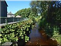
Gruggies Burn near Silverton Avenue
The view is from a little footbridge that crosses the burn just to the north of Silverton Avenue in Dumbarton East. East End Park is directly ahead; the burn turns left to head SSW along the eastern margin of the park (as shown in Image) before flowing under the main road (Image).
Image: © Lairich Rig
Taken: 24 Aug 2016
0.13 miles
8
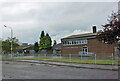
St Patrick's Primary School, Dumbarton
Located adjacent to Dumbarton Academy in Crosslet Road, St Patrick's is a West Dunbartonshire Council Roman Catholic primary school with a current roll of approximately 360 pupils.
Image: © Richard Dorrell
Taken: 11 Aug 2021
0.13 miles
10
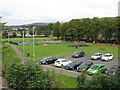
Car park & children's playground north of Dumbarton East station
Image: © Peter Whatley
Taken: 16 Sep 2014
0.13 miles